Table of Contents
Explore all 43 chapters of the Encyclopedia, organized across six thematic parts.

Geography & Physiography
The physical landscape of Emery County: plateaus, canyons, rivers, and the defining topography of the region. Covers physiographic provinces, drainage basins, elevation gradient, structural geology, soils, karst, and aeolian landforms.
Deep-Time Geology
A billion-year journey through stone: Precambrian foundations, Paleozoic seas, Mesozoic dinosaurs, and recent tectonics.
Hydrology & Springs
Water in the desert: springs, seeps, rivers, and the hydrologic systems that sustain life in Emery County.
Climate & Weather
Climate as invisible architecture: precipitation, temperature, and weather patterns shaping life across Emery County's elevation gradient.
Flora Zones
Plant communities from high-elevation forests to desert shrublands: ecology and species across elevational gradients.
Fauna
Wildlife across the elevation gradient: mammals, birds, reptiles, fish, and invertebrates of Emery County's diverse habitats.
Night Skies & Astronomy
Dark skies and celestial wonders: constellations, milky way viewing, and the astronomical heritage of the high desert.
Ancestral Puebloans & Fremont
The first peoples: Fremont culture, Ancestral Puebloans, and the archaeological record of ancient settlement.
Fremont Culture
The most visible ancient culture in Emery County: Fremont pit houses, pottery, irrigation, and the spectacular rock art panels of the San Rafael Swell.
Numic Expansion
The Numic peoples — ancestors of the Ute, Southern Paiute, and Shoshone — and their arrival on the Colorado Plateau after the Fremont decline.
Navajo & Puebloan Interactions
Athabaskan migration, Pueblo Revolt diaspora, trade networks, pastoral revolution, and the deep cultural exchanges between Navajo, Puebloan, and Ute peoples across the Colorado Plateau.
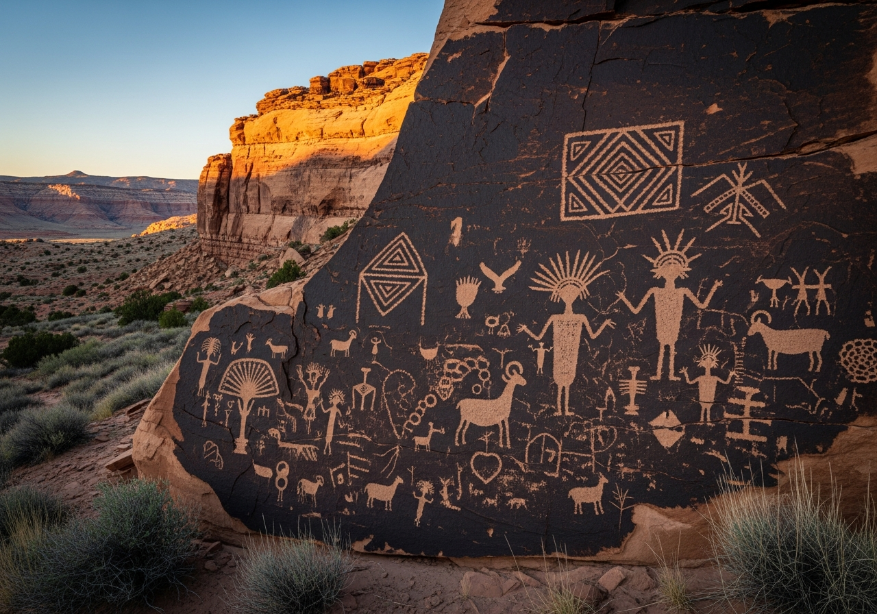
Rock Art & Sacred Landscapes
Barrier Canyon Style, Fremont, and Ute rock art traditions across 400+ documented sites in Emery County — styles, chronology, preservation, and Indigenous stewardship of sacred landscapes.
Archaeological Stewardship
Legal frameworks, monitoring programs, site stewardship, curation practices, and ethical principles for protecting Emery County’s archaeological resources on BLM, tribal, and private lands.
Spanish Trails & Fur Trappers
The era of exploration and trade preceding Euro-American settlement: ancient Ute commerce routes, the Old Spanish Trail, Mexican pack-train operators, and American mountain men in Emery County canyon country.
Powell Expeditions
John Wesley Powell’s 1869 and 1871–72 voyages through Desolation Canyon and the Green River corridor: scientific mapping, photography, and the founding of the U.S. Geological Survey.
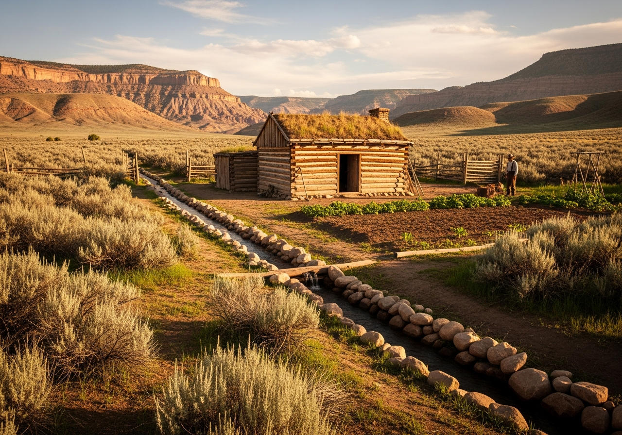
Mormon Colonization
LDS settlement of Emery County: the call to colonize Castle Valley, founding of pioneer towns, cooperative irrigation, and the transformation of a remote desert into an agricultural community.
Coal, Copper & Uranium
The extractive century: coal seams of the Wasatch Plateau, uranium-rich sandstones of the San Rafael Swell, copper byproducts, company towns, the Wilberg and Crandall Canyon disasters, and the ongoing energy transition reshaping Emery County’s economy.
Rails, Roads & Infrastructure
The transportation and utility networks that wove Emery County into the broader region: the Old Spanish Trail, the 1883 Denver & Rio Grande Western main line, federal highways, Interstate 70 through the San Rafael Swell, rural electric and telephone cooperatives, and the coal-to-electricity pipeline.
Water for the Desert
Water, the defining constraint of Emery County life: pioneer ditches and the 1890s salinization crisis, the federal Emery County Project (Joe’s Valley, Huntington North, Millsite), the Colorado River Compact, the Emery Water Conservancy District, and the twenty-first-century megadrought.
Agriculture & Ranching
Pioneer canal-building and cooperative irrigation, the salinization crisis, the federal Emery County Project's dams and reservoirs, alfalfa and hay farming, Green River's celebrated melons, cattle and sheep ranching on public lands, and the water future facing Emery County agriculture.
Energy Transition
From coal peak to post-carbon crossroads: mine closures, shifting retirement timelines for Hunter and Huntington power plants, the billion-dollar Green River Energy Center, workforce retraining gaps, property tax pressures, and Emery County's uncertain but emerging new economic identity.
Demography & Social Change
From pioneer founding cohort to post-coal crossroads: population boom and bust, LDS social architecture, an aging and shrinking workforce, school enrollment cliff, healthcare access gaps, and the resilience of a community navigating energy transition and demographic change.
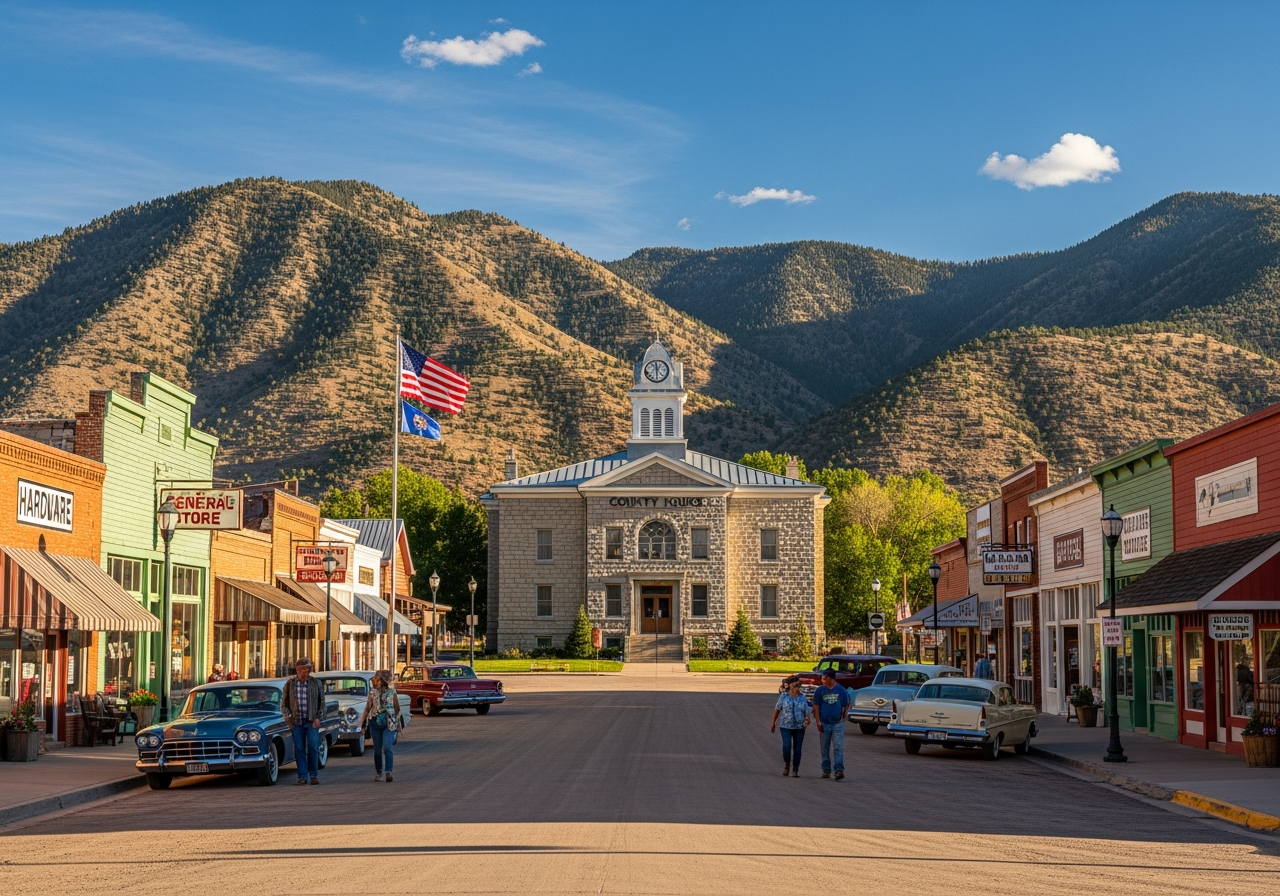
County Governance
From territorial formation in 1880 through the Dingell Act of 2019: the Board of County Commissioners, elected offices, federal land management conflicts, the fiscal impact of coal decline, and the political culture of one of Utah's most reliably conservative rural counties.
Education & Learning
From dugout-classroom pioneer schoolhouses through the Emery Stake Academy (1889-1922), the three-high-school era, and the 1962 consolidation into the Emery High Spartans, to today's Emery County School District (ten schools, ~2,248 students), USU Eastern's Castle Dale education center, and the post-coal CTE pipeline confronting workforce transition - a 145-year arc of education in Castle Valley.
Religious Life
A 145-year religious history of Emery County: Indigenous spiritual landscapes that predate settlement, the 1882 LDS Emery Stake and 1982 Castle Dale/Ferron division, the Presbyterian mission school in Ferron (1906-1950s), Greek Orthodox spillover from the Carbon County coalfields after the 1924 Castle Gate disaster, two enduring small Catholic congregations, released-time seminary and Relief Society networks, and a 21st-century pluralization in which roughly one in three residents now claims no religious affiliation.
Arts, Literature & Media
Emery County's cultural footprint runs unusually deep for a county of fewer than 10,000 residents: pioneer brass bands and Welsh choral traditions; coal-camp music carried in by Greek, Italian, and Slavic miners; a 118-year-old county newspaper; the Emery Telcom/ETV broadcasting cooperative; the Castle Valley Pageant performed every other summer for nearly half a century; a four-museum circuit; folk-craft guilds; and a San Rafael Swell that has doubled as a Hollywood backdrop.
Festivals, Folklore & Foodways
Emery County's participatory culture - the festivals, foodways, and folk arts that knit a population of fewer than 10,000 across 7,000 square miles. The county calendar from the Pioneer Day rodeo cluster (Castle Dale's RMPRA-sanctioned Cowboys Memorial Rodeo, Huntington Heritage Days, Emery, Orangeville) through Ferron Peach Days (1906) and Green River Melon Days (1906), the Emery County Fair, and the Castle Valley Pageant (since 1978); layered foodways of pioneer Mormon dryfarming, coal-camp Welsh-Cornish-Greek-Italian-Slavic kitchens, and modern ranching tables; cowboy-poetry, fiddling, choral, quilting, and storytelling traditions.
Notable People & Oral Histories
A representative gallery of Emery County's people from 1877 to the present: Indigenous voices, founding pioneers (Orange Seely + the 1880 Emery Stake, Hyrum Seely, Henry U. Burr, Rasmus Johnson), the four Swasey brothers (1875), Butch Cassidy at Castle Gate (1897-04-21), Sid's Mountain WSA, Ned Chaffin, the 1984 Wilberg / 2007 Crandall Canyon memorial archive (Karen Jobe Templeton bronzes; Markosek-Ardohain 2016 monument), county commissioners and sheriffs, educators and midwives, religious leaders (LDS, Presbyterian Ferron mission 1906-1950s, Catholic, Greek Orthodox), writers and artists (Stella McElprang 1949, Edward A. Geary 1985-1996, Edwin Montell Seely 1934-2008), Emery County Progress editors from H.T. Haines (1900) forward, and the five-door oral-history apparatus (Emery County Archives, BYU L. Tom Perry, USU Fife, UHS Oral History Program, FamilySearch). Tribal review flag carried from vault.
Health, Safety & Emergency
From frontier midwives and the 1918 influenza pandemic through Castleview Hospital (1980, Level IV Trauma 2023) and Emery Medical Center in Castle Dale, to Four Corners Community Behavioral Health (the first rural-Utah Opioid Treatment Program clinic), the Carbon-Emery overdose-mortality crisis (47.7/100k 2014-2016, 2.5x state rate) and the rebuilding treatment scaffold. Covers the Sheriff's Office and county jail, Emery County Search and Rescue (~50 missions/yr, San Rafael Swell coverage), the volunteer fire districts and ambulance services, and emergency management for floods, wildfires, hazmat, and earthquake. The institutions that close the distance in a 4,500-square-mile county where the nearest hospital has always been across the line in Carbon.
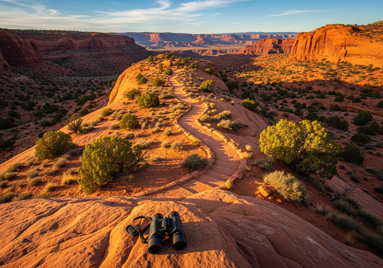
Landscapes of Adventure
A practical field guide to Emery County's adventure landscape: San Rafael Swell slot canyons and OHV routes, Goblin Valley State Park, Joe's Valley world-class bouldering, multi-day Green River trips through Labyrinth and Desolation Canyons, Wasatch Plateau fishing, and the safety essentials for one of the most remote corners of the American West.
Parks & Monuments
From Goblin Valley State Park to Jurassic National Monument: Emery County's four state parks, a BLM national monument, and the 217,000-acre San Rafael Swell Recreation Area — each site's origin story, managing agencies, and what it offers visitors in one of the most protected public-land landscapes in the American West.
Trails & Routes
The complete trail grammar of Emery County: Buckhorn Wash Scenic Backway, Little Wild Horse and Bell Canyon slot-canyon loop, Black Box technical canyoneering, Muddy Creek wilderness backpacking, Joe's Valley mountain biking, the 600-mile Arapeen OHV system, Labyrinth Canyon river float, and the Old Spanish Trail historical corridor.
Climbing, Canyoneering & Rivers
Emery County's technical outdoor recreation: Joe's Valley world-class bouldering (V0-V13+, mid-1990s development, Ben Moon's Black Lung), the San Rafael Swell's hidden canyons, Upper and Lower Black Box technical canyoneering, Muddy Creek and The Chute, Little Wild Horse and Bell Canyon family slots, the spring San Rafael River float through the Little Grand Canyon, and the Green River corridor staging Labyrinth Canyon (free permit) and Desolation Canyon (lottery permit) river trips - with flash flood safety, BLM permit guidance, seasonal calendar, and skill-level matrix.
Wildlife Watching
A field guide to wildlife observation across Emery County's three habitat zones - the Wasatch Plateau high country, the San Rafael Swell desert uplift, and the Green River riparian corridor - covering bighorn sheep, mule deer, elk, pronghorn, raptors, songbirds, reptiles, native and introduced fish, the seasonal viewing calendar, and ethical wildlife-watching practice in a county with Utah's largest desert bighorn herd.
Night Sky Tourism
Dark skies as Emery County's emerging tourism resource: Goblin Valley State Park's 2016 International Dark Sky designation, Bortle Class 1-2 skies across the San Rafael Swell, ranger-led star parties, Venus transit dates (1874/1882) visible from the county, light-pollution trends from Kyba et al. (2023), and the practical field-guide essentials - seasonal viewing windows, equipment, photography techniques, and the public-lands etiquette that keeps the county's night sky among the darkest in the lower 48.
Travel & Logistics
The practical infrastructure of visiting Emery County: I-70's longest service-station gap in the lower 48 (the 'fill up every time' rule), the gateway communities of Green River (pop. 902), Price, Castle Dale, Ferron, and Hanksville, lodging and camping by community and BLM dispersed area, fuel and food and water planning, the spotty cellular coverage that makes a satellite communicator close to mandatory, visitor centers and ranger stations, BLM and state-park permits and fees, the four-season climate split between the Wasatch Plateau and the Swell, EMSAR contact protocols, the Ten Essentials adapted for desert canyon country, and a sustainable-visitation framework.
Archives, Museums & Libraries
The working back-of-the-book for Emery County research: the County Archives in Castle Dale, the Museum of the San Rafael, the Pioneer Museum, the eight-branch library system, the Utah State Archives, the fully digitized Emery County Progress run, three university repositories at USU and BYU, and the practical research workflow that ties them all together.
Historic Registries
Emery County's 22 National Register of Historic Places listings, one National Historic Landmark (Cleveland-Lloyd Dinosaur Quarry), the parallel National Natural Landmark designation, the Old Spanish National Historic Trail, Jurassic National Monument (2019), and the procedural mechanics of how to nominate a property and what designation actually protects.
Mapping & GIS
Maps and digital tools for a county where four out of five acres are federal: USGS topographic quads (historic and current), statewide UGRC GIS portals, Emery County GIS parcel data, BLM Travel Management Plan maps, the 2024 statewide sub-meter lidar coverage, the Utah Geological Survey map series, and the field apps (CalTopo, Gaia GPS, onX) that put it all in a researcher's pocket.
Citizen Science
Community-driven science in Emery County: iNaturalist biodiversity documentation, eBird migration monitoring, CoCoRaHS precipitation filling a rural data gap, Globe at Night dark-sky measurement, Utah Water Watch stream quality, SKYWARN severe-weather spotting, paleontology and archaeological site stewardship, and the citizen-naturalist programs that extend professional research across one of the most data-sparse landscapes in the American West.
Further Reading
Curated bibliography and further reading for deeper exploration of Emery County topics.
Glossary
Definitions of geological, cultural, historical, and technical terms used throughout the encyclopedia.
Systematic Index
Comprehensive index enabling cross-reference navigation through topics, names, places, and concepts.