Part 2 · Peoples
Archaeological Stewardship
Legal frameworks, monitoring programs, site stewardship, curation practices, and ethical principles for protecting Emery County's archaeological resources on BLM, tribal, and private lands.
Ch13 — Archaeological Stewardship
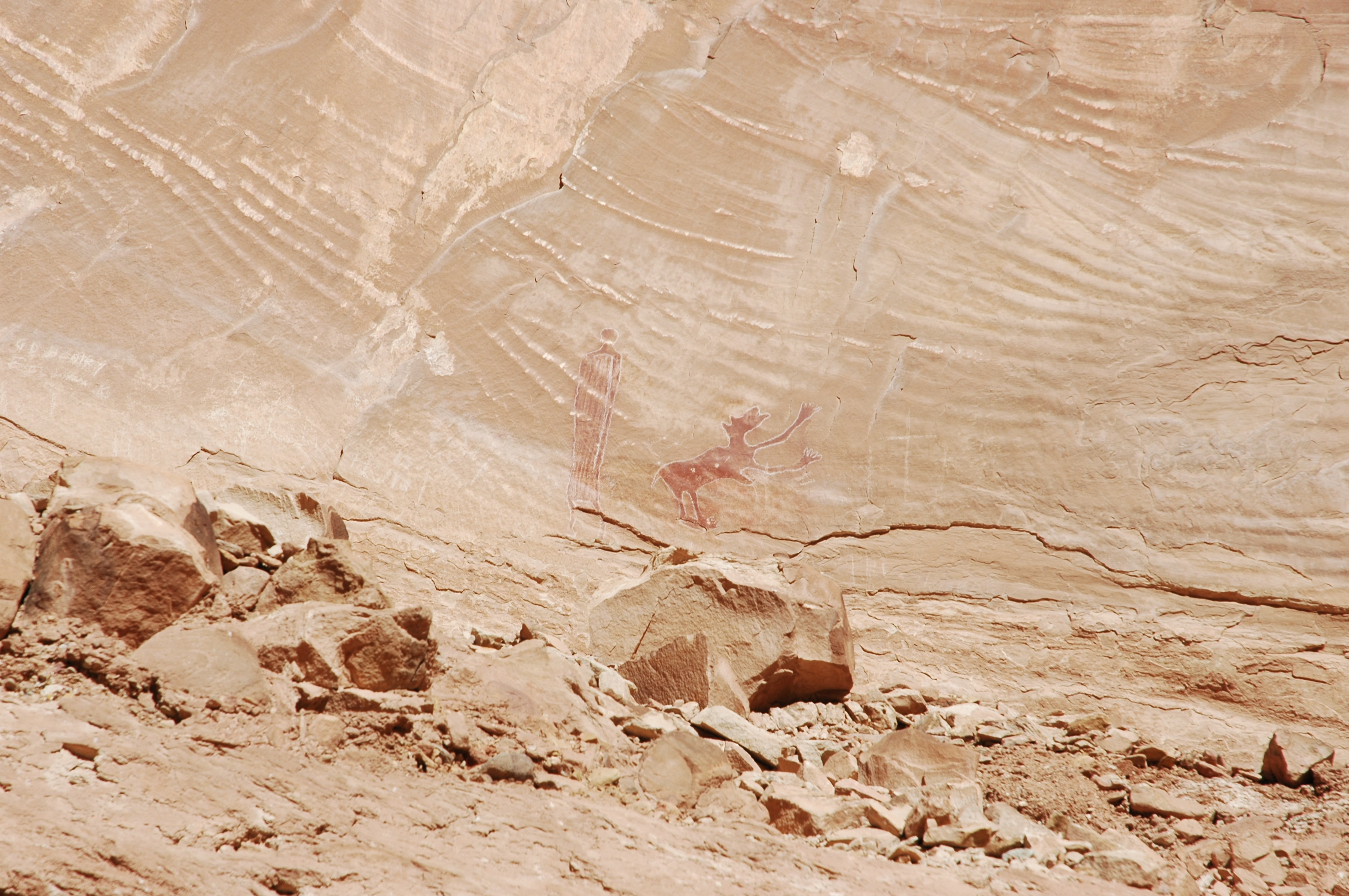
The sandstone walls and mesa tops of Emery County hold a record of human presence stretching back more than ten thousand years. Barrier Canyon Style pictographs peer from alcoves in the San Rafael Swell. Fremont granaries cling to ledges above seasonal washes. Ute rock art panels mark trails and territorial boundaries across the high plateaus. These sites are irreplaceable — once damaged, no law or technology can restore them. Archaeological stewardship is the collective effort to ensure that the cultural heritage embedded in Emery County’s landscape survives for the people who will come after us.
This chapter examines the legal frameworks, monitoring programs, curation practices, technological tools, and ethical principles that shape how Emery County’s archaeological resources are protected and interpreted. It is, in a sense, the practical companion to the preceding chapters: where Chapters 8 through 12 told the story of the people who made these sites, Chapter 13 asks how we keep those stories intact.
13.1 Principles of Archaeological Stewardship
Archaeological stewardship rests on a straightforward premise: the physical traces of past human activity — rock art, stone tools, structural ruins, hearth deposits, burials — are finite and non-renewable. Unlike a forest that can regrow or a river that can be restored, a vandalized pictograph panel or a looted burial site is gone forever. The discipline therefore emphasizes prevention over restoration, community involvement over top-down enforcement, and long-term thinking over short-term convenience.
In practice, stewardship operates at several scales. At the broadest level, federal and state laws establish the legal obligation to protect cultural resources on public lands. At the institutional level, museums and repositories curate the physical objects that have been lawfully excavated, ensuring they remain accessible for research and education. At the community level, volunteer site stewards walk the landscape, reporting damage and educating visitors. And at the individual level, every hiker, rancher, and off-road enthusiast who chooses not to touch a petroglyph or pocket an arrowhead is practicing stewardship in its most elemental form.
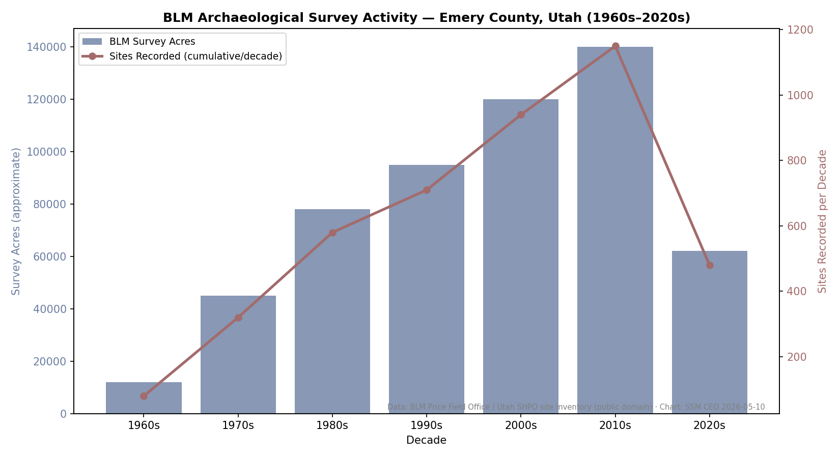
Emery County presents both unusual opportunities and unusual challenges for this work. The county encompasses roughly 4,462 square miles, much of it federal land managed by the Bureau of Land Management. The BLM Price Field Office, which oversees most of the county’s public lands, employs only two archaeologists and one law enforcement ranger — a staffing ratio that makes community partnership not merely desirable but essential. The sheer density of cultural sites in areas like the San Rafael Swell, Buckhorn Draw, and the canyons feeding into the Green River means that professional staff alone cannot monitor, let alone protect, everything that matters.
Emery County covers 4,462 square miles — roughly the size of the state of Delaware — most of it federal land managed by the Bureau of Land Management. The BLM Price Field Office employs exactly two archaeologists and one law enforcement ranger to protect that entire landscape. Each archaeologist is professionally responsible for more than 2,200 square miles of canyon country containing hundreds of documented archaeological sites. This is not negligence — it is the unavoidable arithmetic of a vast public landscape. It is also the reason volunteer site steward programs are not a nice-to-have extra: they are the difference between monitoring and not monitoring.
— BLM Price Field Office staffing records; UCSSP annual report, 2024
13.2 Federal and State Preservation Laws
The legal architecture protecting archaeological resources in the United States developed in layers over more than a century, each law responding to a particular failure of the preceding framework.
The Antiquities Act of 1906 was the first federal statute to criminalize the unauthorized excavation or destruction of antiquities on federal land. It also authorized the president to designate national monuments — a provision that would later shape the protection of landscapes near Emery County, including the designation of areas within the broader Colorado Plateau. The Act’s penalties were modest, however, and enforcement proved difficult across the vast public lands of the American West.
The National Historic Preservation Act of 1966 (NHPA) introduced a more systematic approach. Its Section 106 requires any federal agency undertaking a project — a road, a pipeline, a grazing allotment renewal — to assess the project’s potential impact on historic properties and to consult with the State Historic Preservation Officer (SHPO) and affected tribes before proceeding. Section 110 further requires federal agencies to inventory and evaluate cultural resources on their lands for listing on the National Register of Historic Places. For Emery County, where BLM-managed land dominates the landscape, Section 106 review is a routine but critical part of nearly every land-use decision.
The Archaeological Resources Protection Act of 1979 (ARPA) addressed the Antiquities Act’s enforcement gaps by establishing meaningful penalties: felony violations can result in fines up to $100,000 and imprisonment up to two years for repeat offenders. ARPA also requires permits for all archaeological excavation on federal and Indian lands, specifies federal ownership of excavated materials, and mandates that collections be curated in approved repositories. The BLM’s Permit for Archaeological Investigation (PAI) system in Utah implements ARPA’s requirements at the field level.
The Native American Graves Protection and Repatriation Act of 1990 (NAGPRA) shifted the legal landscape in a different direction. Rather than focusing solely on site protection, NAGPRA recognized that archaeological collections held by museums and federal agencies often included human remains and sacred objects that rightfully belonged to descendant communities. The act requires institutions receiving federal funding to inventory their holdings, determine cultural affiliation, and return eligible items to lineal descendants or culturally affiliated tribes. NAGPRA’s implications for Emery County are discussed in detail in Section 13.10.
At the state level, Utah Code 9-8a-305 — the state’s Antiquities Act — parallels the federal framework by requiring permits for archaeological excavation on state lands. Principal investigators must hold graduate degrees in anthropology, archaeology, or history, plus at least one year of field experience in Utah archaeology. Violations are classified as class B misdemeanors, and convicted persons forfeit all discovered resources to the state. The Utah SHPO reviews both federal undertakings (under Section 106) and state undertakings (under Utah Code 9-8-404) for cultural resource impacts. A 2020 State Protocol Agreement between BLM Utah and the SHPO streamlines the Section 106 process for routine BLM actions, reducing paperwork while maintaining protective standards.
The John D. Dingell Jr. Conservation, Management, and Recreation Act of 2019 added a significant new layer of protection specific to Emery County. The act designated the San Rafael Swell Recreation Area — approximately 217,000 acres — and explicitly listed cultural resource protection as a co-equal management priority alongside recreation, ecology, and scenic values. The act also established a Recreation Area Advisory Council that includes a seat for an elected leader of a federally recognized tribe with significant cultural or historic connections to the landscape, ensuring that tribal perspectives are structurally embedded in management decisions.
The Legal Architecture of Archaeological Protection
| Law | Year | Key Protection |
|---|---|---|
| Antiquities Act | 1906 | First federal law against unauthorized excavation on public land |
| National Historic Preservation Act | 1966 | Section 106 review; National Register; tribal consultation required |
| Archaeological Resources Protection Act | 1979 | Permits required; felony penalties up to $100,000 and 2 years imprisonment |
| Native American Graves Protection Act | 1990 | Requires return of human remains and sacred objects to affiliated tribes |
| Dingell Act (San Rafael Swell) | 2019 | 217,000-acre Recreation Area; statutory tribal seat on advisory council |
Each law was passed because the previous one proved insufficient. ARPA's felony penalties exist because the Antiquities Act's misdemeanor fines didn't deter looting. NAGPRA exists because ARPA said nothing about the human remains already sitting in museum storage.
13.3 Tribal Consultation and Co-Management Models
The archaeological sites of Emery County are not merely scientific resources — they are places of deep cultural significance to the Indigenous peoples whose ancestors created them. Effective stewardship requires that tribal voices play a central role in decisions about how these sites are managed, interpreted, and accessed.
Utah’s formal tribal consultation framework centers on the Native American Remains Review Committee, established under state law and housed within the Division of Indian Affairs. The committee includes representatives from the Ute Indian Tribe of the Uintah and Ouray Reservation, the Paiute Indian Tribe of Utah, and the Confederated Tribes of the Goshute, along with museum professionals and university researchers. It advises on the development of state NAGPRA rules and makes recommendations regarding the care and disposition of Native American remains discovered on state lands.
At the tribal level, the Ute Mountain Ute Tribal Historic Preservation Office (THPO) exemplifies the growing capacity of tribes to manage their own heritage. The THPO’s stated mission is to preserve and promote the cultural heritage of the Ute people on all Ute Ancestral Lands — a mandate that extends well beyond reservation boundaries to encompass the broader landscape of eastern Utah, including Emery County. THPOs operate under the authority of the 1992 amendments to the NHPA, which allow tribes to assume many of the functions of State Historic Preservation Offices on tribal lands and to participate as sovereign parties in Section 106 consultation for projects affecting off-reservation sites.
The trend in federal land management is toward co-management models that give tribes a structural role in decision-making rather than merely a consultative one. The Dingell Act’s inclusion of a tribal seat on the San Rafael Swell Recreation Area Advisory Council is one example. Nationally, the Bears Ears National Monument in neighboring San Juan County has become the most prominent test case for tribal co-management of public lands with significant archaeological resources. While Emery County’s situation differs in scale and specifics, the principle is the same: the descendants of the people who created these sites have knowledge, perspectives, and rights that cannot be replicated by federal archaeologists or state bureaucracies.
13.4 Site Monitoring and Reporting Protocols
The most sophisticated legal framework is only as effective as the people who watch over the sites it protects. In Emery County, site monitoring depends on a combination of professional staff, trained volunteers, and an increasingly engaged public.
The Utah Cultural Site Stewardship Program (UCSSP), administered by the Utah SHPO under Utah Code 9-8a-205, is the backbone of volunteer monitoring statewide. As of 2024, the program supports more than 460 volunteers who regularly monitor, assess, and report on the status of more than 1,000 archaeological and culturally significant sites across all 29 Utah counties, partnering with federal, state, municipal, and private landowners. In 2024 alone, stewards collectively traveled more than 86,000 miles, invested 5,252 hours in monitoring and training, and submitted an average of 100 reports per month. Each steward is trained through sessions conducted by the Stewardship Coordinator and agency archaeologists, then matched to specific sites based on their abilities, interests, and proximity.
The program’s value was demonstrated dramatically during the 2025 federal government shutdown, when BLM staff were furloughed and archaeological sites on federal land went unmonitored by professionals. UCSSP volunteers stepped up independently, continuing their regular monitoring rounds and reporting conditions to the state office — a reminder that community investment can sustain protection even when institutional capacity falters.
For Emery County specifically, the BLM Price Field Office coordinates with UCSSP stewards to cover high-priority sites in the San Rafael Swell, Buckhorn Draw, and the canyons along the Green River. The office’s limited staffing — two archaeologists and one law enforcement ranger for the entire field office area — makes this partnership not a luxury but a necessity. Stewards serve as the “eyes and ears” of professional archaeologists, detecting vandalism, natural erosion, unauthorized excavation, and visitor impacts that might otherwise go unnoticed for months or years.
Reporting protocols follow a standardized system. When a steward identifies damage or a potential threat, they complete a site condition report documenting the nature and extent of the issue, photograph the affected area, and submit the report to both the UCSSP coordinator and the responsible land management agency. Urgent threats — active vandalism, looting in progress, structural collapse — trigger immediate notification of law enforcement. The Buckhorn Draw petroglyph vandalism case, in which graffiti was etched across four panels potentially 3,000 years old, illustrates both the threat and the response: the BLM Price Field Office investigated, media coverage raised public awareness, and organizations like Friends of Cedar Mesa offered a $2,500 reward for information leading to prosecution (BLM, 2025).
In 2024, the Utah Cultural Site Stewardship Program fielded more than 460 trained volunteers who collectively traveled 86,000 miles, invested 5,252 hours in monitoring and training, and filed an average of 100 condition reports per month — all to watch over more than 1,000 cultural sites across Utah's 29 counties. Those 86,000 miles are more than three times around the Earth, driven and hiked by retired teachers, weekend hikers, ranchers, and families who decided that something irreplaceable was worth showing up for. When BLM staff were furloughed during the 2025 federal government shutdown, UCSSP volunteers kept monitoring independently.
— Utah Cultural Site Stewardship Program, annual report 2024
Become a Site Steward: Join the Volunteer Network
Adults and youth who want to move from passive visitor to active protector can apply to the Utah Cultural Site Stewardship Program (UCSSP) through the Utah State Historic Preservation Office. Training takes about a day and covers site identification, photography protocols, condition reporting, and how to recognize vandalism vs. natural deterioration. Graduates are matched to specific sites based on location, interests, and physical ability. Monitoring visits take 1–3 hours; reports are filed online using a standardized form. Families can participate together with an adult as the official volunteer of record. Start at heritage.utah.gov to find the current enrollment contact and upcoming training dates. In 2024, UCSSP volunteers traveled more than 86,000 miles to protect sites that would otherwise have gone unwatched.
13.5 Museum Curation and Artifact Repositories
When archaeological materials are lawfully excavated — whether through permitted research, compliance-driven salvage ahead of construction, or emergency recovery — they must be curated in approved repositories that meet federal standards for storage, security, environmental control, and public access. Two institutions serve as the primary repositories for materials from Emery County and the surrounding region.
The USU Eastern Prehistoric Museum in Price, Utah — located just across the county line in Carbon County — is the nearest major archaeological repository to Emery County. Operated by Utah State University, the museum holds more than 700,000 archaeological artifacts, with some estimates placing the total above one million. Its collections emphasize the Fremont archaeological culture, the farming communities that occupied much of present-day Utah from roughly 400 to 1300 CE. As both a state and federal repository, the museum receives materials excavated from public lands across the region and maintains them under conditions that meet the Secretary of the Interior’s standards for curation.
The Edge of the Cedars State Park Museum in Blanding, approximately 150 miles south of Emery County, houses the largest collection of Ancestral Puebloan pottery and artifacts in southeastern Utah. As an accredited archaeological repository, it serves as the primary home for materials excavated from public lands in the southeastern corner of the state. Its archives, research library, and environmentally controlled storage facilities allow archaeologists to study regional cultural patterns without disturbing new sites — an approach that embodies the stewardship principle of maximizing knowledge while minimizing impact.
Together, these institutions demonstrate the dual function of archaeological curation: preserving the physical evidence of the past and making it accessible for ongoing research and public education. For Emery County residents and visitors, the USU Eastern Prehistoric Museum in Price offers the most accessible window into the county’s deep archaeological heritage.
USU Eastern Prehistoric Museum
The nearest major window into Emery County's deep past — 700,000+ artifacts, the Fremont Culture in full, and a repatriation story worth hearing.
On the ground
The museum holds more than 700,000 archaeological artifacts — one of the largest collections in the American West. The Fremont Culture gallery is the centerpiece: ceramics, clay figurines, stone tools, and architectural models drawn from sites across the region Emery County sits within. Look for the replica Pilling Figurines — the originals were returned to the Ute Indian Tribe in 2011 under NAGPRA, one of the museum's most significant repatriation completions. The mammoth skeleton in the main hall anchors the deeper geological timeline. The museum represents exactly the curation model described in this chapter: lawfully excavated materials, preserved under federal standards, made accessible for research and public education.
See also: Chapter 9 (Fremont Culture) · Chapter 13 §13.10 (NAGPRA Repatriation)
13.6 Public Outreach and Educational Programs
Stewardship depends ultimately on public understanding. If residents and visitors do not know why archaeological sites matter — or how easily they can be damaged — even the best laws and monitoring programs will fall short.
Several programs operate at the intersection of education and preservation in the Emery County region. Project Archaeology, a national heritage education program supported by the BLM, provides professional development and classroom materials for K–12 teachers, helping them teach students about past and present cultures while encouraging active participation in heritage protection. In Utah, the BLM has partnered with Southern Utah University to expand Project Archaeology’s reach, engaging a wider range of teachers and students in heritage education.
The BLM’s “Visit with Respect” messaging campaign, visible at trailheads and interpretive sites throughout the San Rafael Swell, distills stewardship into simple behavioral guidelines: leave artifacts where they are, stay out of ancient structures, avoid touching rock art panels, and report damage. These messages reflect decades of experience showing that most site damage comes not from deliberate vandalism but from well-meaning visitors who do not understand the fragility of what they are encountering.
The Friends of Cedar Mesa, though based in San Juan County, provides a statewide model for community-driven archaeological advocacy. The organization partners with the BLM to build site steward networks, funds rewards for information about vandalism (up to $2,500 per case), and advocates for stronger legal protections for cultural resources on public lands. Similar grassroots efforts in Emery County — whether through existing organizations or new ones — could significantly enhance local capacity for site protection and public engagement.
Document the Infrastructure: Photograph What Makes Visiting Sustainable
- Your subject
- The protective and interpretive infrastructure at a publicly-accessible archaeological or rock art site — the BLM kiosk, boardwalk, viewing fence, 'Visit with Respect' signage, and any volunteer presence you encounter
- Where to find it
- What to look for
- The story you're telling
- The infrastructure between you and the rock art is itself a record of stewardship decisions made by agencies, tribes, archaeologists, and community members over decades. Photographing it is documenting the human effort that keeps this site accessible to anyone who wants to visit.
Share your photo with #EmeryEncyclopedia
13.7 Cultural Resource Management
Cultural Resource Management (CRM) is the professional discipline that translates preservation law into on-the-ground practice. In Emery County, CRM work is driven primarily by the Section 106 review process under the NHPA, which requires federal agencies to identify and assess cultural resources before undertaking any action that might affect them.
The process works as follows. When the BLM Price Field Office proposes an action — approving a grazing permit renewal, authorizing a pipeline right-of-way, designating a new recreation trail — it must first determine whether the action could affect historic properties. If the potential exists, the agency commissions an archaeological survey of the affected area. The survey is conducted by permitted archaeologists who walk the ground, document any cultural resources they encounter, and assess their eligibility for the National Register of Historic Places. If significant resources are identified, the agency must consult with the Utah SHPO, affected tribes, and other stakeholders to develop a plan that avoids, minimizes, or mitigates adverse effects.
The 2020 State Protocol Agreement between BLM Utah and the SHPO streamlines this process for routine undertakings by establishing standard procedures and thresholds that field offices can apply without individual case-by-case consultation. The agreement maintains protective standards while reducing the administrative burden that can slow both preservation and development.
Energy development has been a persistent CRM challenge in Emery County. The county’s coal mining heritage (see Chapter 17) and more recent oil and gas exploration have generated numerous Section 106 reviews. Road construction, well pad development, pipeline installation, and associated infrastructure all require cultural resource clearance. In areas like Nine Mile Canyon — located primarily in Carbon and Duchesne counties but culturally continuous with Emery County’s archaeological landscape — energy development was identified as such a significant threat that the canyon was placed on the National Trust for Historic Preservation’s list of America’s Most Endangered Places in 2004.
Increasing recreational use of the San Rafael Swell presents a newer CRM challenge. The Dingell Act’s designation of the Recreation Area brought welcome legal protections but also increased visitation, creating the paradox familiar to land managers everywhere: the same public interest that justifies protection also generates the foot traffic, vehicle erosion, and social-media exposure that threaten fragile sites.
13.8 Disaster Response and Site Emergency Planning
Archaeological sites face natural threats that no amount of legal protection can prevent. Flash floods — common in Emery County’s canyon country during late-summer monsoon season — can scour sediment from buried sites, undercut rock art panels, or deposit debris across fragile surfaces. Wildfires, though less frequent in the county’s arid lowlands, can destroy organic materials at surface sites and alter the microenvironment of rock shelters. Freeze-thaw cycles gradually exfoliate the sandstone surfaces that bear pictographs and petroglyphs, a slow but relentless form of deterioration.
Emergency response protocols for archaeological sites differ from those for structures or infrastructure. The priority is documentation: if a site is actively being damaged by a natural event, the first response is to record its condition as thoroughly as possible so that the extent of loss can be assessed afterward. The BLM’s cultural resource staff, supplemented by UCSSP volunteers, conduct post-event assessments after major floods or fires, comparing current conditions to baseline documentation. Sites identified as at imminent risk — a panel on an undercut cliff face, a structure in a flood-prone drainage — may be prioritized for stabilization measures such as water diversion, structural bracing, or protective barriers.
Climate change adds a layer of uncertainty to disaster planning. Shifting precipitation patterns, more intense storm events, and longer fire seasons all have the potential to accelerate site deterioration in ways that current monitoring programs may not be equipped to detect. Proactive documentation — recording sites in high-resolution digital formats before damage occurs — is increasingly seen as a form of insurance against losses that cannot be prevented.
13.9 Technological Tools: GIS, LiDAR, and Drone Survey
Technology has transformed archaeological stewardship from a discipline that relied almost entirely on boots-on-the-ground observation to one that can see through vegetation, map landscapes from the air, and share data across institutions in real time.
Geographic Information Systems (GIS) form the foundational layer. The Utah Geospatial Resource Center (UGRC) maintains statewide spatial datasets that archaeologists, land managers, and planners use to locate known sites, model site probability, plan surveys, and track management actions. The Utah SHPO’s compliance system integrates GIS data into the Section 106 review process, allowing agencies to quickly identify whether a proposed project area overlaps with known cultural resources. For Emery County, GIS data layers can overlay archaeological site locations with land ownership, topography, hydrology, vegetation, and management boundaries — enabling a landscape-scale view of cultural resource distribution and vulnerability.
LiDAR (Light Detection and Ranging) has emerged as one of the most powerful tools for archaeological discovery and documentation. By firing laser pulses from aircraft and measuring their return, LiDAR generates high-resolution digital elevation models that can reveal archaeological features hidden beneath vegetation — building foundations, earthworks, agricultural terraces, roadways, and canal systems. Utah acquired extensive LiDAR coverage during 2022, when UGRC, FEMA, the U.S. Forest Service, and the Natural Resources Conservation Service collectively surveyed approximately 19,466 square miles at Quality Level 1 and 2 resolution, producing bare-earth digital elevation models at 0.5 to 1 meter resolution. Much of Emery County’s terrain falls within this coverage area.
Drone-based LiDAR has further democratized the technology. Ultra-compact, relatively low-cost LiDAR systems can now be deployed on consumer-grade drones, enabling archaeologists to collect their own high-resolution aerial data for specific sites and landscapes without the expense of full-scale airborne surveys. In Emery County’s rugged terrain, where many archaeological sites occupy canyon alcoves, mesa edges, and cliff faces that are difficult to survey on foot, drone-based LiDAR and photogrammetry offer a way to document sites with minimal physical disturbance.
Additional technologies — including ground-penetrating radar (GPR), magnetometer surveys, and high-resolution photogrammetric modeling — complement LiDAR by providing subsurface data and three-dimensional site reconstructions. Heritage consultants increasingly integrate multiple data streams into unified GIS platforms, producing comprehensive site maps that serve both research and management needs.
13.10 Ethical Considerations and Repatriation
The history of archaeology in the American West is inseparable from the history of colonialism. For much of the nineteenth and twentieth centuries, the excavation and collection of Native American materials — including human remains — was conducted with little regard for the wishes of descendant communities. Museums and universities accumulated vast collections of skeletal remains, funerary objects, and sacred items, many of which were taken from sites in Utah and surrounding states.
NAGPRA, enacted in 1990, established the legal framework for addressing this legacy. The act requires institutions that receive federal funding to inventory their holdings of Native American human remains and associated funerary objects, determine the cultural affiliation of those materials, and notify and consult with affiliated tribes about their return. The process is detailed and often slow: cultural affiliation must be established through evidence that may include tribal oral tradition, historical documentation, biological analysis, and archaeological context.
In Utah, the scale of the repatriation challenge is significant. Data compiled by ProPublica’s NAGPRA database indicates that institutions have not yet made available for return the remains of at least 1,500 Native Americans taken from counties of interest to the Ute Indian Tribe of the Uintah and Ouray Reservation. The Natural History Museum of Utah has maintained long-established NAGPRA consultation policies and designed its Native Voices gallery through extensive collaboration with Utah’s Native tribes — a model for how institutions can engage with descendant communities in good faith.
Beyond the legal requirements of NAGPRA, broader ethical questions continue to evolve. Should human remains be displayed in museums at all? Who has the authority to interpret a site’s meaning — the archaeologist who excavates it, or the descendants of the people who created it? How should researchers balance the scientific value of studying ancient materials against the cultural and spiritual concerns of living communities? These questions do not have simple answers, but the trend in professional archaeology is clear: toward greater deference to tribal perspectives, more collaborative research frameworks, and a recognition that stewardship is not something that can be done to Indigenous heritage — it must be done with the people to whom that heritage belongs.
How NAGPRA Repatriation Works: Five Steps
| Step | What Happens | Who Leads |
|---|---|---|
| Inventory | Institution catalogs all human remains and associated funerary objects in its collections | Museum or federal agency |
| Cultural affiliation | Evidence is gathered from oral tradition, historical records, biological analysis, and archaeological context to link items to a tribe | Institution + tribal consultation |
| Notification | The affiliated tribe receives formal written notice identifying eligible items available for return | Institution |
| Consultation | Tribe and institution discuss return conditions, timeline, and handling protocols | Tribe as primary decision-maker |
| Repatriation | Physical transfer of remains or objects to the tribe; institution updates its records | Tribe receives; institution documents |
NAGPRA was enacted in 1990. More than 30 years later, the process remains incomplete at many institutions — ProPublica's database shows at least 1,500 Native American remains not yet available for return to tribes with connections to Utah counties.
13.11 Collaborative Research Initiatives
Archaeological knowledge advances through collaboration — between universities and land management agencies, between professional researchers and avocational archaeologists, and between scientific institutions and tribal communities. Several collaborative models are relevant to Emery County.
University-based research has long contributed to understanding the county’s archaeological record. Brigham Young University, the University of Utah, and Utah State University have all conducted fieldwork in Emery County and the surrounding region, particularly in the San Rafael Swell and the canyons of the Wasatch Plateau. These projects generate not only published research but also trained graduate students who often go on to careers in CRM, federal land management, or museum curation — extending the impact of each project well beyond its immediate findings.
The Nine Mile Canyon Coalition’s Project Discovery represents a community-driven research model. Though Nine Mile Canyon lies primarily in Carbon and Duchesne counties, its cultural continuity with Emery County’s archaeological landscape makes the coalition’s work directly relevant. Project Discovery combines professional archaeological survey with public engagement, inviting volunteers to participate in documentation and monitoring under professional supervision. This model builds public investment in archaeological preservation while generating useful data.
Tribal-academic partnerships represent the most important frontier in collaborative research. As tribal historic preservation offices develop greater capacity and as federal agencies increasingly require meaningful tribal consultation, the traditional model of university-led excavation followed by museum curation is giving way to more reciprocal arrangements. In these partnerships, research questions are developed jointly, fieldwork is conducted collaboratively, and the resulting knowledge is shared with descendant communities — not merely published in academic journals. For Emery County, such partnerships could deepen understanding of Fremont, Ute, and Barrier Canyon Style sites while respecting the cultural concerns that surround them.
13.12 Best Practices and Future Directions
Archaeological stewardship in Emery County stands at a pivotal moment. The legal foundation is strong — federal and state laws provide meaningful protections, and the Dingell Act’s designation of the San Rafael Swell Recreation Area adds a new layer of statutory authority. The volunteer infrastructure is growing — the UCSSP’s statewide network demonstrates that communities will invest in heritage protection when given the training and institutional support to do so. And technological tools are more powerful than ever, offering ways to document, monitor, and study sites with unprecedented precision and minimal physical impact.
Several best practices have emerged from the accumulated experience of agencies, tribes, researchers, and volunteers working in Utah and across the American West. First, prevention outperforms response: investing in public education, site steward programs, and proactive monitoring is far more cost-effective than investigating vandalism after the fact or salvaging materials from damaged sites. Second, tribal engagement must be structural, not token: a seat on an advisory council matters more than an annual consultation meeting. Third, technology should supplement, not replace, human presence on the landscape: LiDAR can find sites, but only a person walking the ground can notice that someone has been digging where they shouldn’t. Fourth, data sharing across agencies, institutions, and jurisdictions — while protecting the confidentiality of sensitive site locations — enables more efficient and effective management than siloed approaches.
Citizen-Scientist Site Watch: Practice the Monitoring Protocol
- □ Photograph the site from three different angles with a scale reference (a coin, a hand, or a person) visible in at least one frame.
- □ Record the GPS coordinates, date, time, and weather — the basics of a professional condition report.
- □ Observe and note any of the following: vegetation overgrowth obscuring features, erosion, graffiti, missing stones, unauthorized vehicle tracks, or anything that looks different from what the interpretive sign describes.
- □ Write a short trip report (3–5 sentences) describing only what you observed — no interpretation, just documentation.
- □ If you see active vandalism or looting, report it: BLM Price Field Office (435-636-3600) or Utah SHPO (801-245-7226). Never touch or move anything — your photographs are evidence.
Share your finds! #EmeryEncyclopedia
Looking ahead, the most significant challenge may be the one that is hardest to legislate: sustaining public commitment to stewardship over decades and generations. Laws can be amended, budgets can be cut, and volunteer programs can lose momentum. What endures is a culture of care — a shared understanding that the rock art on the canyon wall, the stone tools in the wash, and the ruins on the mesa are not merely interesting objects but irreplaceable records of human experience that belong to everyone and to no one. Building and maintaining that culture of care is, in the end, the most important work of archaeological stewardship.
Sources
- Antiquities Act of 1906, 16 U.S.C. §§ 431–433
- National Historic Preservation Act of 1966, 54 U.S.C. § 300101 et seq.
- Archaeological Resources Protection Act of 1979, 16 U.S.C. §§ 470aa–470mm
- Native American Graves Protection and Repatriation Act of 1990, 25 U.S.C. §§ 3001–3013
- John D. Dingell Jr. Conservation, Management, and Recreation Act of 2019, P.L. 116-9
- Utah Code Annotated § 9-8a-205 (Cultural Site Stewardship Program)
- Utah Code Annotated § 9-8a-305 (Antiquities; Permits for Archaeological Investigation)
- Utah SHPO, “Cultural Resource Compliance Guidance,” 2024
- BLM–Utah State Protocol Agreement, 2020
- BLM Price Field Office, cultural resource enforcement records
- Utah Cultural Site Stewardship Program, annual reports (2024)
- ProPublica, NAGPRA Repatriation Database (Ute Indian Tribe records)
- Natural History Museum of Utah, NAGPRA consultation records
- USU Eastern Prehistoric Museum, collections documentation
- Edge of the Cedars State Park Museum, repository accreditation records
- Utah Geological Survey and UGRC, LiDAR acquisition records (2022)
- Fox13 News, “Petroglyphs nearly 3,000 years old vandalized in Emery County,” 2025
- BLM, “$2,500 Rewards Offered for Information on Archaeological Resource Vandalism”
- Nine Mile Canyon Coalition, Project Discovery documentation
Proposed Maps and Figures
- Map: BLM-managed lands in Emery County showing major archaeological site clusters and the San Rafael Swell Recreation Area boundary
- Diagram: Section 106 review process flowchart (from project proposal through SHPO consultation to resolution)
- Photo: Buckhorn Draw Pictograph Panel — Barrier Canyon Style rock art
- Photo: UCSSP volunteer conducting site monitoring in the field
- Photo: USU Eastern Prehistoric Museum Fremont Culture collection display
- Map: Statewide UCSSP coverage with Emery County sites highlighted
- Diagram: NAGPRA repatriation process from inventory through consultation to return
Proposed Tables
- Table: Federal and state laws protecting archaeological resources (law, year, key provisions, penalties)
- Table: UCSSP program statistics (2024) — volunteers, sites monitored, hours, miles, reports
- Table: Major archaeological repositories serving Emery County (institution, location, collection size, specialization)