Part 1 · Foundations
Deep-Time Geology
A billion-year journey through stone: Precambrian foundations, Paleozoic seas, Mesozoic dinosaurs, and recent tectonics.
Chapter 2 — Deep-Time Geology
Emery County is an open book of Earth history. Nowhere else in the continental United States does a single county expose such a continuous record of geologic time — from Pennsylvanian marine limestones more than 300 million years old to the Quaternary landslides still reshaping the Wasatch Plateau today. The county owes this legibility to two forces: the Colorado Plateau’s long structural stability, which preserved layer upon layer of sediment in near-horizontal repose, and the relentless erosion that has since carved those layers into the cliffs, canyons, and mesas that define the landscape.
This chapter traces that record from oldest to youngest, formation by formation, connecting the rocks beneath a reader’s boots to the ancient seas, deserts, rivers, and mountains that deposited them.
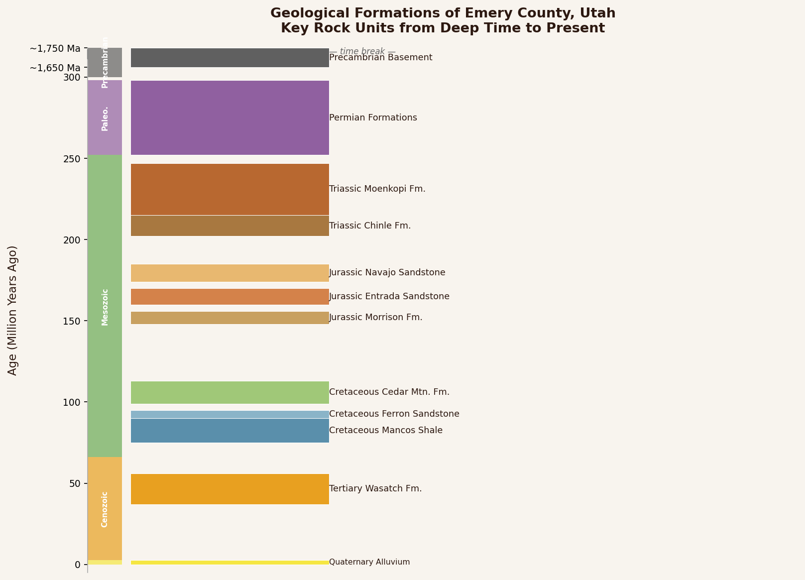
2.1 The Stratigraphic Column: Reading Emery County’s Rock Record
A stratigraphic column is geology’s table of contents — a vertical stack of rock units arranged from oldest at the bottom to youngest at the top. Emery County’s column is unusually complete. The U.S. Geological Survey catalogues formations spanning every major period from the Pennsylvanian (323–299 Ma) through the Quaternary, with the thickest and most dramatic exposures concentrated in the Mesozoic and Late Cretaceous (USGS Mineral Resources, Emery County geologic units).
The key to this completeness is the Colorado Plateau itself. While the Basin and Range to the west was stretching and faulting, and the Rocky Mountains to the east were crumpling under compressional forces, the Plateau behaved like a rigid raft — subsiding gently to receive sediment, then rising as a coherent block without the internal deformation that elsewhere destroys or obscures the record. The result is a layer cake of sedimentary rock thousands of feet thick, now tilted and sliced open by the San Rafael Swell, the Book Cliffs, and the canyons of the Green River system.
The sections that follow walk through this column from bottom to top, pausing at each major interval to describe what was happening on the ancient landscape that would become Emery County.
Emery County's Rock Record at a Glance
| Formation | Age (Ma) | Ancient Setting | Economic Legacy |
|---|---|---|---|
| Paradox Formation | ~310–299 | Restricted tropical sea | Oil & gas traps; potash |
| Coconino / White Rim Ss | ~280–270 | Sahara-scale sand desert | Scenic canyon walls |
| Chinle Formation | ~230–200 | River floodplains & lakes | Uranium ore host |
| Morrison Formation | ~155–148 | Braided-river plains | Cleveland-Lloyd Dinosaur Quarry |
| Blackhawk Formation | ~80–72 | Coal swamps & delta plains | A century of coal mining |
| Mancos Shale | ~95–80 | Open ocean seafloor | Namesake of the Emery Formation |
These six formations alone span nearly 250 million years and account for most of Emery County's economic heritage — coal, uranium, oil and gas, and the dinosaur fossils that put the county on the world scientific map.
2.2 The Hidden Foundation: Precambrian Basement
No Precambrian rocks crop out at the surface in Emery County. The ancient crystalline basement — granites, gneisses, and metamorphic rocks more than a billion years old — lies buried thousands of feet below the visible landscape, known only from deep wells and geophysical surveys. The nearest surface exposures of Precambrian rock occur in the Uinta Mountains to the north, where thick sequences of Proterozoic quartzites and shales record the edge of the proto–North American continent.
Beneath Emery County, this rigid basement acts as the structural stage on which all subsequent geologic drama plays out. Its buried topography — ancient ridges and valleys — influenced where later seas pooled, where sediment accumulated most thickly, and where faults would eventually propagate upward during the Laramide Orogeny. Though invisible, the Precambrian foundation shapes everything above it.
2.3 Paleozoic Seas and Shores (323–252 Ma)
The oldest rocks exposed at the surface in Emery County are Pennsylvanian and Permian in age, roughly 323 to 252 million years old, and they tell a story of warm, shallow tropical seas and vast coastal dune fields.
Pennsylvanian Period (323–299 Ma). During this interval, the region that would become Emery County lay near the equator on the western margin of the supercontinent Pangaea. Shallow marine seas advanced and retreated repeatedly across the area, depositing the carbonates and evaporites of the Hermosa Group. The Paradox Formation — the deepest and most economically significant member — accumulated thick sequences of salt, potash, and organic-rich shale in restricted marine basins. These evaporites would later become targets for oil and gas exploration and, in neighboring counties, potash mining. Above the Paradox, the Honaker Trail Formation records a return to open marine conditions with fossiliferous limestones and sandstones (Hintze & Kowallis, 2009).
Permian Period (299–252 Ma). As Pangaea consolidated and the seas withdrew, the landscape shifted from marine to coastal and eventually to desert. The Cutler Group records this transition: the Elephant Canyon and Cedar Mesa formations at the base preserve marine and near-shore deposits, while the overlying Organ Rock Shale and White Rim Sandstone document a vast coastal dune field. In the San Rafael Swell, the Coconino Sandstone — the local equivalent of the White Rim — is a massive, cross-bedded, buff-to-white quartzarenite up to 715 feet thick, its sweeping cross-strata preserving the slip faces of ancient sand dunes (USGS geologic units, Emery County). The Kaibab Limestone caps the Permian section, recording a final marine transgression before the seas retreated for good.
These Paleozoic rocks are best seen in the deeply eroded interior of the San Rafael Swell, where the oldest formations — roughly 300 million years old — are exposed at the center of the dome, surrounded by concentric rings of progressively younger strata.
During the Pennsylvanian Period, roughly 310 million years ago, the land that would become Emery County sat near the equator — part of the western margin of the supercontinent Pangaea. By the Permian, the sea had retreated and a desert rivaling the modern Sahara spread across the region. The Coconino Sandstone now exposed in the Swell's interior preserves 715 feet of wind-blown dunes, their sweeping cross-strata frozen in stone. Next time you drive through the San Rafael Reef on I-70, those pale cliff walls are a Permian sand sea — grain by grain, dune by dune.

2.4 The Red Beds: Triassic Landscapes (252–201 Ma)
The Triassic Period opened in the aftermath of Earth’s most severe mass extinction, the end-Permian event that wiped out an estimated 90 to 96 percent of marine species. Recovery was slow, and the early Triassic landscape across what would become Emery County was a low-lying, arid-to-semiarid mudflat drained by sluggish rivers.
Moenkopi Formation. The lowermost Triassic unit in Emery County, the Moenkopi is a sequence of reddish-brown mudstones with thin interbeds of limestone and siltstone. Its ripple marks, mudcracks, and occasional fish and reptile tracks record a tidal-flat and shallow-marine environment along the margin of a retreating sea. The Moenkopi forms the distinctive “chocolate ledges” visible on benchlands around the San Rafael Swell.
Chinle Formation. An unconformity — a gap in the record representing millions of years of erosion — separates the Moenkopi from the overlying Chinle Formation. The Chinle is a colorful sequence of shales, mudstones, and conglomerates deposited by braided rivers and in lakes and marshes during the Late Triassic. Its basal Shinarump Conglomerate Member, a coarse sandstone and pebble conglomerate filling ancient stream channels, is the principal uranium ore host in the San Rafael Swell. The uranium was concentrated by groundwater flowing through organic-rich sediments in a fluvial-deltaic-lacustrine environment — a process geologists call “roll-front” mineralization (USGS Bulletin 1239). Petrified wood is common in the Chinle, and the formation’s purple, green, and gray banded exposures are among the most photogenic in the county.
2.5 The Great Sand Seas: Jurassic Deserts and Dunes (201–145 Ma)
The Jurassic Period brought the most dramatic landscape transformation in Emery County’s geologic history: the development of enormous sand seas, or ergs, that rivaled the modern Sahara in scale.
Glen Canyon Group. The Wingate Sandstone forms the sheer, rust-red cliffs that define many of the county’s most iconic canyons. It was deposited as wind-blown dunes in a vast, arid desert during the earliest Jurassic. Above it, the Kayenta Formation records a brief return to fluvial conditions — its thin-bedded sandstones and siltstones were laid down by braided streams threading between dune fields. The Navajo Sandstone, the thickest and most widespread unit in the Glen Canyon Group, caps this sequence with cross-bedded eolian sandstone reaching up to 2,000 feet in southern Utah near Zion National Park, thinning to roughly 440 to 540 feet through the San Rafael Swell. Its massive, sweeping cross-strata — visible in the walls of slot canyons throughout the Swell — record the migration of enormous sand dunes across an arid landscape. Recent uranium-lead dating of carbonate deposits within the Navajo has confirmed an earliest Jurassic age for the formation (Geology, 2019).
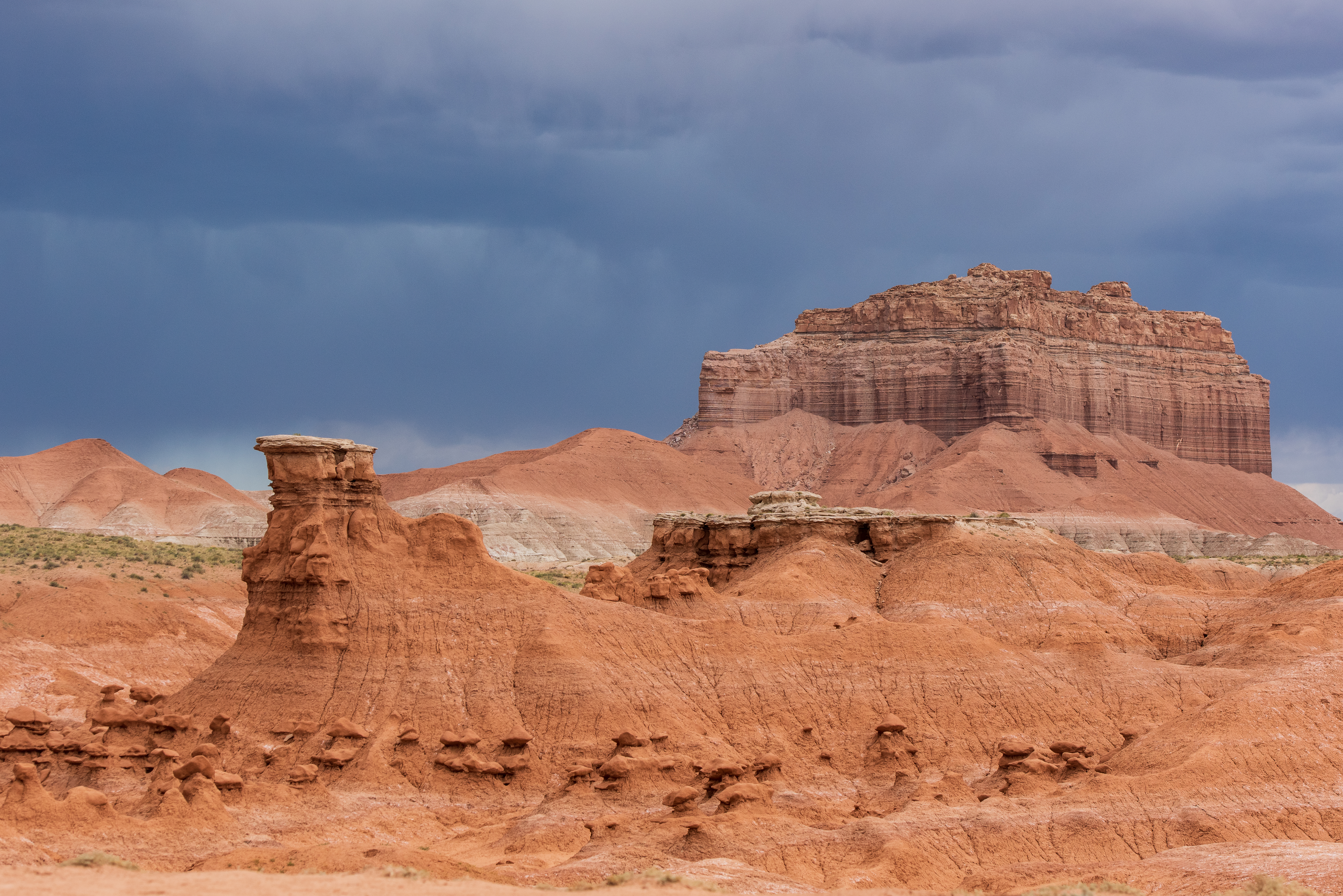
San Rafael Group. By the Middle Jurassic, conditions grew more varied. The Carmel Formation records marine incursions from the north — thin limestones, siltstones, and gypsum beds deposited in a shallow, restricted sea. The Entrada Sandstone above it returns to eolian and sabkha (salt-flat) conditions; its differentially weathered hoodoos and goblins are the signature landforms of Goblin Valley State Park. The Curtis Formation and Summerville Formation cap the San Rafael Group with marine and tidal-flat deposits, respectively, recording the last significant Jurassic marine transgression across the region.
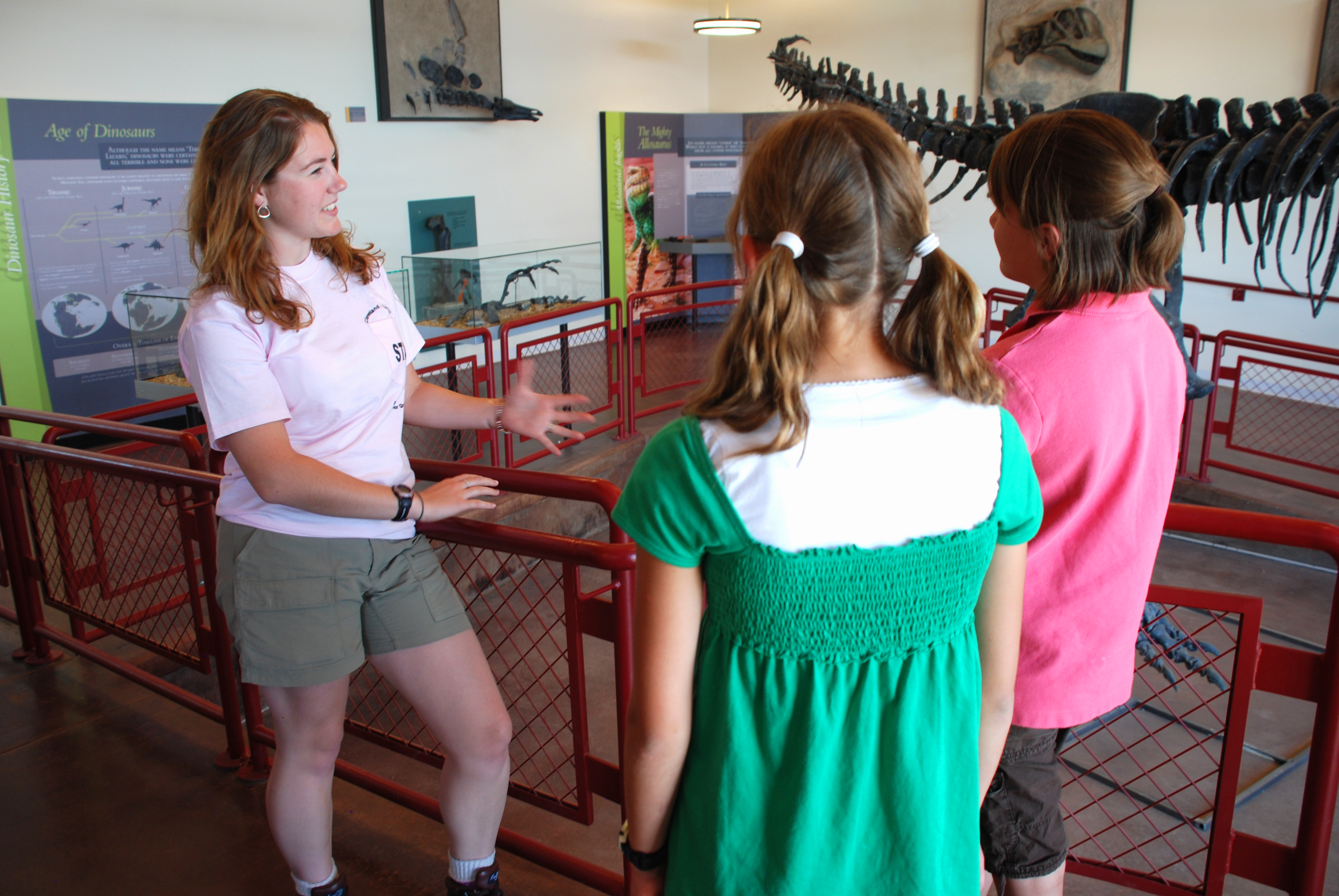
Morrison Formation. The crowning unit of the Jurassic section is the Morrison Formation, a Late Jurassic sequence of variegated mudstones, sandstones, and conglomerates deposited by meandering rivers on a broad alluvial plain. The Morrison is 148 to 155 million years old and is the most prolific dinosaur-bearing formation in North America. In Emery County, it is the host rock of the Cleveland-Lloyd Dinosaur Quarry, located about 30 miles south of Price in the Brushy Basin Member. Over 12,000 bones representing at least 74 individual dinosaurs have been excavated from this single site, approximately 75 percent of which belong to the predator Allosaurus fragilis. The quarry’s bone bed — a calcareous smectitic mudstone deposited on the floodplain of an anastomosing river system — has been interpreted as an attritional assemblage where carcasses were transported post-mortem into an ephemeral pond during flood conditions, rather than a predator trap as earlier researchers proposed (Peterson et al., 2017). Designated a National Natural Landmark in 1966 and incorporated into Jurassic National Monument in 2019, the Cleveland-Lloyd Quarry is one of Emery County’s most significant scientific and cultural assets.
The Cleveland-Lloyd Dinosaur Quarry has produced more than 12,000 bones from at least 74 individual dinosaurs — roughly 75 percent of them from the predator Allosaurus fragilis. Why so many predators in one place? Scientists debated it for decades. The current leading hypothesis: carcasses washed into an ephemeral pond during floods, attracting scavengers that also became mired and died, reinforcing the cycle. The quarry is still actively excavated, and new specimens continue to emerge from the Brushy Basin mud.
Frozen Desert: Navajo Sandstone Cross-Bedding
- Your subject
- A cliff face or canyon wall in the Navajo Sandstone showing large-scale cross-bedding — sweeping diagonal lines within the rock that preserve the slip faces of ancient sand dunes.
- Where to find it
- Little Wild Horse Canyon, Bell Canyon, or Ding-Dang Canyon in the San Rafael Swell interior (access via Temple Mountain Road off I-70). The Navajo's pale buff-to-cream walls are unmistakable.
- What to look for
- Each set of diagonal lines (foresets) is one dune's slip face, preserved exactly as it was roughly 180 million years ago. Sets sweep in broad arcs and may shift direction between layers, recording changes in ancient wind patterns over centuries.
- The story you're telling
- You're photographing one of the largest ancient desert ergs in North American geologic history. The dunes were up to 1,000 feet tall. What looks like abstract texture is a record of a world that no longer exists — frozen in stone.
- Composition tip
- Include a person for scale. The dunes you're photographing were taller than any building in Utah.
Share your photo with #EmeryEncyclopedia
2.6 The Cretaceous Seaway: From River Deltas to a Continental Ocean (145–66 Ma)
The Cretaceous Period brought the most consequential geologic event in Emery County’s economic history: the advance and retreat of the Western Interior Seaway, a shallow ocean that split North America from the Gulf of Mexico to the Arctic. The formations deposited along the seaway’s shifting shoreline would later yield the coal that powered a century of mining.
Cedar Mountain Formation. The Early Cretaceous (127–98 Ma) is represented by the Cedar Mountain Formation, named by William Lee Stokes in 1944 for exposures at Cedar Mountain in northern Emery County. This sequence of variegated mudstones and sandstones, deposited by rivers and in lakes, has yielded numerous dinosaur species. The recently described Short Canyon Member, identified in the Short Canyon quadrangle of Emery County, has added new data to the formation’s complex stratigraphy (Utah Geological Survey). The Buckhorn Conglomerate at the base of the Cedar Mountain Formation marks a significant erosional unconformity and the onset of Cretaceous sedimentation.
Dakota Sandstone. The thin but persistent Dakota Sandstone marks the initial transgression of the Western Interior Seaway across the region. Its beach and nearshore sandstones record the moment — roughly 98 to 95 million years ago — when the sea advanced westward across what had been a continental interior.
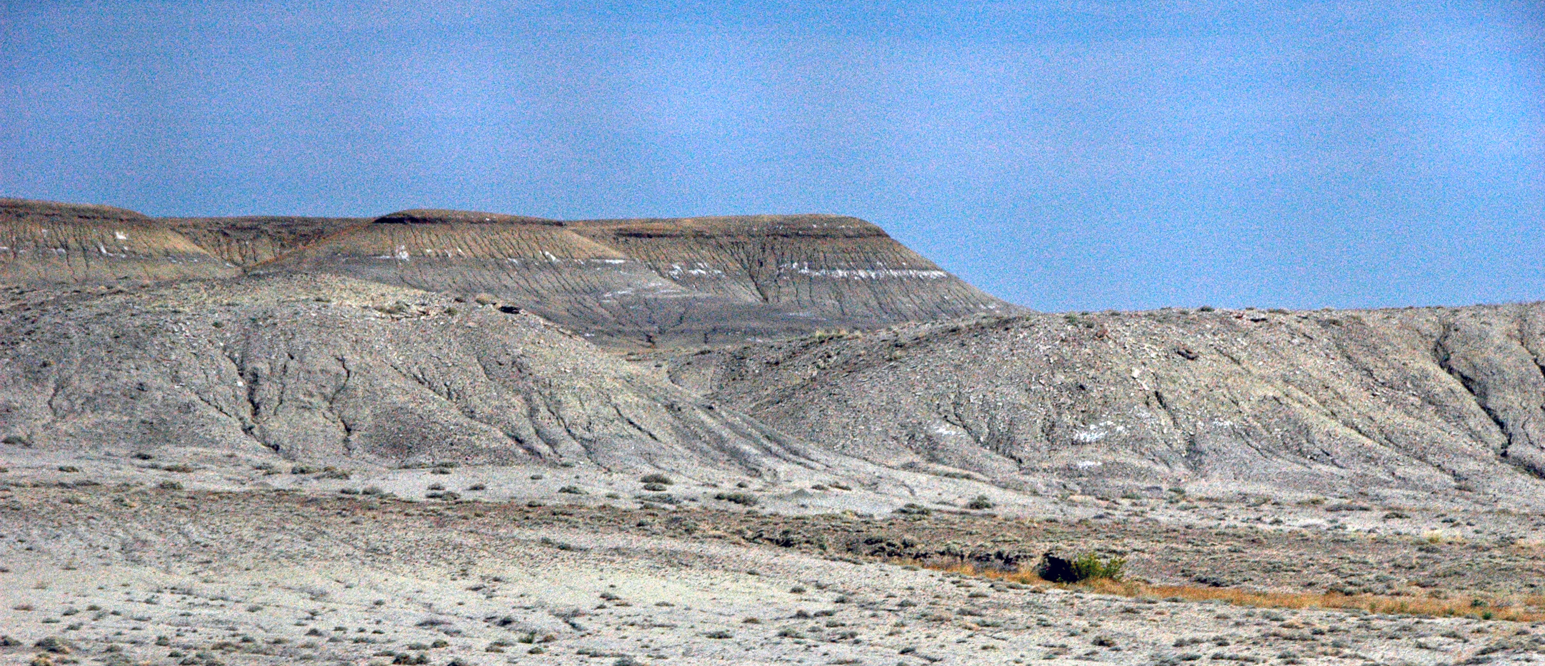
Mancos Shale. As the seaway deepened, it deposited the thick, monotonous gray shales of the Mancos Formation — Emery County’s most voluminous Cretaceous unit. The Mancos accumulated between approximately 95 and 80 million years ago and is divided into several members that record oscillations in sea level and sediment supply: the Tununk Shale Member at the base, the Ferron Sandstone Member (a series of regressive sandstone tongues that cap prominent ridges), the Blue Gate Shale Member, the Emery Sandstone Member (named for Emery County itself), and the Masuk Shale Member at the top. The Ferron Sandstone, approximately 90 million years old, is particularly well-studied as a reservoir analog for subsurface oil and gas exploration worldwide.
Mesaverde Group: Star Point Sandstone and Blackhawk Formation. As the Western Interior Seaway began its final regression, a complex of river deltas and barrier islands prograded eastward across the Emery County area. The Star Point Sandstone records the sandy shoreface of this retreating sea, its four major sandstone tongues trending northwest to southeast, subparallel to the Late Cretaceous paleoshoreline. Above it, the Blackhawk Formation preserves the delta plains, swamps, and back-barrier lagoons that formed behind the retreating shore. It is in these coal swamps — preserved as bituminous coal seams interbedded with sandstones and shales — that Emery County’s mining heritage was born.
Two types of coal accumulated in this setting. Delta-plain coals formed as thin to moderately thick, laterally discontinuous bodies in the sinuous channels and overbank areas of river deltas. Back-barrier coals, deposited in more stable environments behind coastal sand ridges, are thicker and more laterally continuous — and therefore more economically significant. The Blackhawk Formation’s coal seams fueled the mines at Huntington, Emery, Ferron, and Castle Dale that shaped the county’s identity for more than a century (see Chapter 17: Coal, Copper & Uranium).
The Castlegate Sandstone and Price River Formation cap the Mesaverde Group, recording the final pulse of clastic sedimentation as the seaway retreated permanently from the region.
About 85 million years ago, you could have sailed a boat from the Gulf of Mexico to the Arctic Ocean directly across what is now Emery County. The Western Interior Seaway — a shallow inland ocean up to 2,500 feet deep and 600 miles wide — split North America in two for roughly 30 million years. The grey badlands visible around Castle Dale today are the compressed mud that settled on that seafloor. The county's coal seams formed in the coastal swamps along its retreating shoreline.
2.7 The Laramide Orogeny: Building the San Rafael Swell (70–40 Ma)
Between roughly 70 and 40 million years ago, compressional forces generated by the Farallon Plate’s shallow subduction beneath western North America propagated far inland, buckling the otherwise rigid Colorado Plateau. In Emery County, this compression produced the defining structural feature of the landscape: the San Rafael Swell.
The Swell is a massive dome-shaped anticline measuring approximately 75 miles long by 40 miles wide — one of the largest exposed upwarps on the Colorado Plateau. Its southeastern limb, the San Rafael Reef, is steeply inclined to near-vertical, forming a dramatic wall of Navajo and Wingate sandstone hogbacks visible from Interstate 70. The western limb dips more gently. Subsequent erosion has stripped up to 8,000 feet of younger rock from the crest, exposing the Paleozoic core in a bullseye pattern: the oldest rocks (Pennsylvanian, roughly 300 million years old) at the center, surrounded by concentric rings of progressively younger formations.
The Laramide compression also produced Sevier-age ramp-style thrust faults, documented at Cedar Mountain on the northwestern margin of the Swell (Geology, 1988). These faults, which predate the main phase of anticline growth, juxtapose older rocks over younger and influenced the distribution of mineral resources throughout the region.
San Rafael Swell Geology Drive
A 300-million-year tour through one of the Colorado Plateau's best-exposed geologic archives — from Permian limestone at the core to Quaternary alluvium in the washes.
On the ground
At the San Rafael Reef (I-70 corridor), the near-vertical Navajo and Wingate sandstone hogbacks form the upturned eastern limb of the anticline — pull over to photograph the formation contacts. At the Goblin Valley turnoff, Entrada Sandstone hoodoos formed by differential erosion of a Jurassic sabkha and dune field. In the Temple Mountain area, Chinle Formation exposures show banded purple, green, and gray; petrified wood fragments are common on the ground (do not collect — protected on public land). Deep in the interior near Tomsich Butte, Pennsylvanian and Permian limestones surface at the eroded core of the dome — the oldest rocks visible in Emery County, roughly 300 million years old.
See also: Chapter 1: Geography & Physiography · Chapter 17: Coal, Copper & Uranium
2.8 Tertiary Deposits: Lakes, Rivers, and Volcanic Heat (66–2.6 Ma)
After the Laramide compression waned, the early Tertiary landscape of Emery County transitioned from mountain-building to erosion, lake-filling, and volcanism.
North Horn Formation. Straddling the Cretaceous-Tertiary boundary, the North Horn Formation is a mix of fluvial sandstones, lacustrine mudstones, and freshwater limestones deposited as the last of the Western Interior Seaway drained and new drainage systems developed on the emerging Wasatch Plateau. The formation is notable for producing exceptionally large landslides — a property that continues to shape the landscape today (see Section 2.10).
Flagstaff Limestone and Colton/Wasatch Formations. Freshwater lakes occupied intermontane basins during the Paleocene and Eocene, depositing the Flagstaff Limestone. The overlying Colton and Wasatch formations record the fluvial and lacustrine environments that surrounded these lakes — brightly colored mudstones, sandstones, and conglomerates that form the vivid badlands visible in portions of the county’s western margin.
Green River Formation. The most economically tantalizing Tertiary unit is the Green River Formation, deposited in a vast lake system (Lake Uinta) during the Eocene. Its members — the Douglas Creek, Garden Gulch, Parachute Creek, and Evacuation Creek — include oil shale beds containing kerogen, an organic precursor to petroleum. While the richest oil-shale deposits lie in the Uinta Basin to the north, the Green River Formation extends into the northeastern margins of Emery County and has attracted periodic exploration interest.
Laccolithic Intrusions. Between approximately 24 and 28 million years ago, during the late Oligocene and early Miocene, magma intruded into the sedimentary stack without reaching the surface, forming laccolithic bodies of diorite porphyry. These intrusions, analogous to the better-known Henry Mountains to the south, baked and mineralized the surrounding country rock and are associated with localized zones of copper and other metallic minerals.
2.9 The Colorado Plateau Rises: Miocene Uplift and Canyon Cutting
Beginning roughly 23 million years ago, during the Miocene Epoch, the entire Colorado Plateau began rising as a coherent block — a process that continues today. The mechanism remains debated among geologists: some attribute it to thermal buoyancy from mantle upwelling, others to isostatic rebound as dense lower crust was replaced by hotter, less dense material, and still others to far-field effects of Basin and Range extension.
Whatever its cause, the uplift had profound consequences for Emery County. As the plateau rose, stream gradients steepened, and rivers that had previously meandered across low-relief surfaces began cutting vigorously downward. The San Rafael River and its tributaries incised the spectacular slot canyons of the Swell — Little Wild Horse, Bell, and Ding-Dang canyons — following joint sets in the Navajo and Entrada sandstones. The Green River, an antecedent stream that predated the uplift, maintained its course by cutting Desolation and Gray canyons through rising strata. The result is the deeply dissected, canyon-laced landscape that defines Emery County today.
Read the Rocks: A Geologic Time Hunt
- □ Cross-bedding in sandstone — diagonal lines within a rock face, each set the preserved slip face of an ancient sand dune. Look for it on any pale buff or cream sandstone wall.
- □ A sharp color change between two rock layers — you're standing at a formation boundary, the contact between two different ancient worlds.
- □ Ripple marks or mudcracks in reddish siltstone (Moenkopi Formation) — evidence of a tidal flat that existed more than 250 million years ago.
- □ Banded purple, green, and gray mudstone in the Chinle Formation — the colors record different soil and water conditions in ancient river floodplains.
- □ Mancos Shale: dark grey, almost black rock that crumbles into flat flakes. Formed on the floor of an inland sea 85 million years ago. Common in badlands near Castle Dale.
- □ Erosion happening right now: a fresh rockfall scar, an undercut cliff face, or a boulder deposited in a wash by a flash flood.
Share your finds! #EmeryEncyclopedia
2.10 Ice, Landslides, and the Modern Landscape: Quaternary Geology (2.6 Ma–Present)
The Quaternary Period — the last 2.6 million years — put the finishing touches on Emery County’s landscape through glaciation, mass wasting, and alluvial reworking.
Pleistocene Glaciation. During glacial maxima, small alpine glaciers formed on the highest elevations of the Wasatch Plateau. While Emery County never experienced the continental ice sheets that covered the Great Lakes region, its high country bore cirque glaciers whose moraines reflect ice advances in the latest Pleistocene and early Holocene. Evidence of small glaciers persisting into the late Holocene — the last few thousand years — has been documented on the plateau (Utah Geological Survey).
Landslides and Landslide-Dammed Lakes. The North Horn Formation and other clay-rich Tertiary units on the Wasatch Plateau are prone to large-scale mass wasting. Near Joes Valley Reservoir, a landslide 1.2 miles long in the North Horn Formation deflects Seely Creek, and the reservoir dam itself is founded on the flat-lying Blackhawk Formation with its numerous coal beds interlaced among sandstones. Across the plateau, landslide-generated sag ponds — closed depressions that form near the heads of ancient slides — account for many of the region’s natural lakes. At the toes of slides, stream-damming creates additional lakes, though few of these persist because they are prone to overtopping and erosion.
Alluvium and Active Processes. Holocene alluvium blankets the valley floors along Huntington Creek, Cottonwood Creek, Ferron Creek, and the San Rafael River, providing the fertile bottomlands on which Emery County’s agricultural communities were founded. Flash floods continue to rework alluvial fans at canyon mouths — Buckhorn Draw, Little Wild Horse Canyon, and others — depositing boulder lobes proximally and sand aprons distally. Desert pavements, wind-polished ventifacts, and active sand dunes in the lowlands around Green River testify to ongoing aeolian processes. The geology of Emery County is not merely ancient history; it is a living, active system.
Build a Kitchen-Table Stratigraphic Column
Layer sand, gravel, flour, chocolate pudding, colored play-dough, or any materials from your kitchen or yard in a clear glass jar to build Emery County's geologic column from bottom to top. Label each layer with the formation name and age from Section 2.1. Ask: which layer is the Jurassic desert (Navajo Sandstone — pale and cross-bedded)? Which holds the coal swamps (Blackhawk Formation)? Which would you excavate for dinosaur bones (Morrison Formation)? Then flip the jar upside down and ask: now the oldest rocks are on top — what would that tell a geologist reading a cliff face?
What you'll need:
clear glass jar or tall cup, sand, gravel, or soil in different colors, flour, cocoa powder, or cornmeal, colored play-dough (optional), sticky labels and a marker, printed copy of Section 2.1 for reference
2.11 Economic Geology: Resources from the Rock Record
Emery County’s geologic column is not just a scientific record — it is the foundation of the county’s economic history. Each major resource traces to a specific formation and depositional environment:
Coal derives from the swamps and deltas preserved in the Blackhawk Formation of the Mesaverde Group (Late Cretaceous). The Wasatch Plateau coalfield, straddling Carbon and Emery counties, was one of Utah’s most productive, with mines at Huntington, Emery, Ferron, and Castle Dale operating from the late nineteenth century into the twenty-first.
Uranium concentrates in the Shinarump Conglomerate Member of the Chinle Formation (Late Triassic) and the Salt Wash Member of the Morrison Formation (Late Jurassic), both exposed in the San Rafael Swell. Cold War–era demand drove intensive prospecting and mining in the 1950s, leaving a landscape of claim markers and abandoned adits.
Oil and gas are associated with the Paradox Formation evaporites (Pennsylvanian), the Ferron Sandstone (Cretaceous), and structural traps within the San Rafael Swell anticline.
Oil shale occurs in the Green River Formation (Eocene), though commercial extraction has never been pursued at scale within county boundaries.
Copper and other metallic minerals are found in association with the Oligocene–Miocene laccolithic intrusions and in mineralized zones within the San Rafael Swell.
A fuller treatment of mining history and its social and economic impacts appears in Chapter 17: Coal, Copper & Uranium.
2.12 Geologic Hazards and Active Processes
Living on a geologic layer cake has consequences. Emery County faces several hazards rooted in its deep-time geology:
Landslides remain the most persistent geologic hazard, particularly on the Wasatch Plateau where the clay-rich North Horn Formation and Mancos Shale are susceptible to saturation and failure. Road cuts along State Route 31 (Huntington Canyon) and State Route 29 (Joes Valley) periodically reactivate old slide surfaces.
Flash floods exploit the impermeable Mancos Shale badlands and the narrow slot canyons of the San Rafael Swell. Hikers in Little Wild Horse Canyon and Crack Canyon face real danger during monsoon season when upstream thunderstorms send walls of water through channels with no escape.
Expansive soils derived from the Mancos Shale and Chinle Formation swell when wet and shrink when dry, damaging foundations, roads, and pipelines throughout the county’s lowlands.
Radon gas, a decay product of uranium in the Chinle and Morrison formations, can accumulate in basements and enclosed spaces, particularly in communities near the San Rafael Swell.
Understanding these hazards requires understanding the rocks that produce them — a practical reason, beyond intellectual curiosity, to know Emery County’s deep-time geology.
Sources
- Hintze, L.F. & Kowallis, B.J. (2009). Geologic History of Utah. BYU Special Publication 9.
- Doelling, H.H. (2004). Geologic Map of the San Rafael Swell, Utah. Utah Geological Survey Map 193.
- Gilluly, J. (1929). Geology and Oil and Gas Prospects of Part of the San Rafael Swell, Utah. USGS Bulletin 806-C.
- Kerr, D.R. & Kidwell, S.M. (1991). “Stratigraphic Framework and Coal Resources of the Blackhawk Formation and Star Point Sandstone, Wasatch Plateau Coal Field.” USGS Professional Paper.
- USGS Mineral Resources. “Geologic Units in Emery County, Utah.” mrdata.usgs.gov/geology/state/fips-unit.php?code=f49015.
- Utah Geological Survey. “Geologic Map of the Short Canyon Quadrangle, Emery County, Utah.” geology.utah.gov.
- Peterson, J.A. & Turner-Peterson, C.E. (1987). “The Morrison Formation of the Colorado Plateau: Recent Advances in Sedimentology, Stratigraphy, and Paleotectonics.” Hunteria, 2(1).
- Peterson, J.E. et al. (2017). “New Data towards the Development of a Comprehensive Taphonomic Framework for the Late Jurassic Cleveland-Lloyd Dinosaur Quarry, Central Utah.” PeerJ, 5:e3368.
- Lawton, T.F. (1988). “Sevier-age Ramp-style Thrust Faults at Cedar Mountain, Northwestern San Rafael Swell.” Geology, 16(4): 299–302.
- Utah Geological Survey. “What Do Landslides, Glaciers, and Faults Have to Do with the Lakes on the Wasatch Plateau?” Survey Notes.
- USGS Bulletin 1239. Geology, Altered Rocks, and Ore Deposits of the San Rafael Swell.
Proposed Maps
- M1: Geologic map of Emery County showing formation outcrop areas (simplified from UGS/USGS quadrangles)
- M2: Stratigraphic column for Emery County, Precambrian through Quaternary, with formation names, ages, thicknesses, and depositional environments
- M3: Cross-section through the San Rafael Swell anticline (NW–SE), showing folded strata and eroded crest
- M4: Paleogeographic reconstruction: Western Interior Seaway at maximum extent (~85 Ma) with Emery County location marked
- M5: Economic geology overlay — coal, uranium, oil/gas fields, and mineral prospects keyed to host formations
Proposed Figures
- F1: Block diagram of Laramide compression producing the San Rafael Swell anticline
- F2: Schematic stratigraphic column with Emery County formations, color-coded by period
- F3: Cross-section of Blackhawk Formation delta-barrier-island complex showing coal seam geometry
- F4: Diagram of uranium roll-front mineralization in the Chinle Formation
- F5: Annotated photograph of San Rafael Reef hogbacks showing formation contacts
Proposed Photographs
- P1: Pennsylvanian limestone exposed at the core of the San Rafael Swell
- P2: Coconino/White Rim Sandstone cross-bedding in the Swell interior
- P3: Moenkopi “chocolate ledges” with ripple marks and mudcracks
- P4: Chinle Formation banded exposures with petrified wood
- P5: Navajo Sandstone slot canyon walls showing eolian cross-strata
- P6: Entrada Sandstone hoodoos at Goblin Valley
- P7: Cleveland-Lloyd Dinosaur Quarry excavation face
- P8: Ferron Sandstone Member ridge capping Mancos Shale badlands
- P9: Blackhawk Formation coal seam exposure
- P10: Joes Valley landslide terrain on the Wasatch Plateau
Proposed Tables
- T1: Master formation table: Formation name, age (Ma), thickness, depositional environment, economic significance, best exposure location
- T2: Geologic time scale with Emery County formations highlighted
- T3: Economic mineral resources by host formation
- T4: Geologic hazards by formation and geographic area