Part 2 · Peoples
Ancestral Puebloans & Fremont
The first peoples: Fremont culture, Ancestral Puebloans, and the archaeological record of ancient settlement.
Ch08 — Paleo-Indian & Archaic
The story of human life in Emery County begins not with wagons or irrigation ditches but with spear points and campfires — thousands of years before the first European set foot in the Americas. Projectile points dated to roughly 11,000 years ago have been recovered from sites across the county, evidence that Paleo-Indian hunters pursued mammoths, giant bison, and other ice-age mammals through the canyons and plateaus that would one day bear the name Emery (Utah Historical Quarterly, 1998). This chapter traces the long arc from those earliest hunters through the Archaic foragers who adapted, over more than 250 human generations, to a landscape transformed by climate change, megafauna extinction, and the slow accumulation of knowledge about how to live well in arid country.
8.1 Paleo-Indian Big Game Hunting
The Paleo-Indian period in Utah spans roughly 13,000 to 8,000 years before present (BP), a time when the Colorado Plateau was cooler and wetter than today and supported a community of large mammals now long extinct. Across North America, the earliest well-documented hunting tradition is the Clovis culture (~13,050–12,750 BP), whose distinctive leaf-shaped, fluted projectile points have been found from coast to coast. The Clovis people are widely associated with the hunting of Pleistocene megafauna — particularly the Columbian mammoth (Mammuthus columbi) — though their diet almost certainly included smaller game and plant foods as well (Britannica, “Clovis Complex”).
The Folsom tradition followed Clovis by a few centuries (~10,800–10,200 BCE), producing thinner, more elegantly fluted points designed for hafting onto spear shafts and targeting the giant bison (Bison antiquus) that survived the initial wave of megafauna extinction. The discovery of Folsom points in association with extinct bison bones near Folsom, New Mexico, — first uncovered in 1908 by cowboy George McJunkin and scientifically excavated in 1927 — revolutionized American archaeology by proving human antiquity on the continent far exceeded previous estimates (Archaeology Southwest, 2021).
In Emery County, Paleo-Indian projectile points have been surface-collected from multiple locations, though no deeply stratified kill sites comparable to the great Plains discoveries have yet been excavated within county boundaries. The most dramatic evidence of the Paleo-Indian world in the region comes not from human artifacts but from the animals themselves.
The Huntington Mammoth stands as one of the most significant paleontological discoveries in the region. In the summer of 1988, a backhoe operator named Chris Nielson working on the Huntington Dam project in Huntington Canyon — within the Manti-La Sal National Forest in Emery County — unearthed a massive humerus and part of a tusk. Subsequent excavation revealed a nearly complete skeleton of a Columbian mammoth at an elevation of 2,740 meters (8,990 feet), an unusually high-altitude find for the species. The primary radiocarbon date on the bones is approximately 11,220 years BP, with associated materials ranging to approximately 9,440 BP (Cambridge Core, “Columbian Mammoth from the Wasatch Mountains”). Alongside the mammoth, researchers recovered a cranial fragment of the giant short-faced bear (Arctodus simus) — a predator up to fifty percent larger than the largest living bears — as well as remains of mastodon (Mammut americanum), horse (Equus sp.), and bison (Bison sp.). This diverse megafauna assemblage demonstrates that the high plateaus of Emery County supported a rich community of ice-age animals, and by extension, the human hunters who pursued them. The Huntington Mammoth skeleton is now a centerpiece of the USU Eastern Prehistoric Museum in Price, just north of the county line (Utah Geological Survey, “Ice Age Wildlife”; Sanpete County, “Huntington Mountain Mammoth”).
In the summer of 1988, a backhoe operator working on the Huntington Dam project unearthed a nearly complete Columbian mammoth skeleton at 8,990 feet elevation — one of the highest-altitude mammoth discoveries in North America. The bones date to approximately 11,220 years ago, placing this animal in the same era as the first Paleo-Indian hunters in the region. You can see the skeleton at the USU Eastern Prehistoric Museum in Price, just 30 miles north of Castle Dale.
— Cambridge Core; Utah Geological Survey
8.2 Early Lithic Technology & Quarry Landscapes
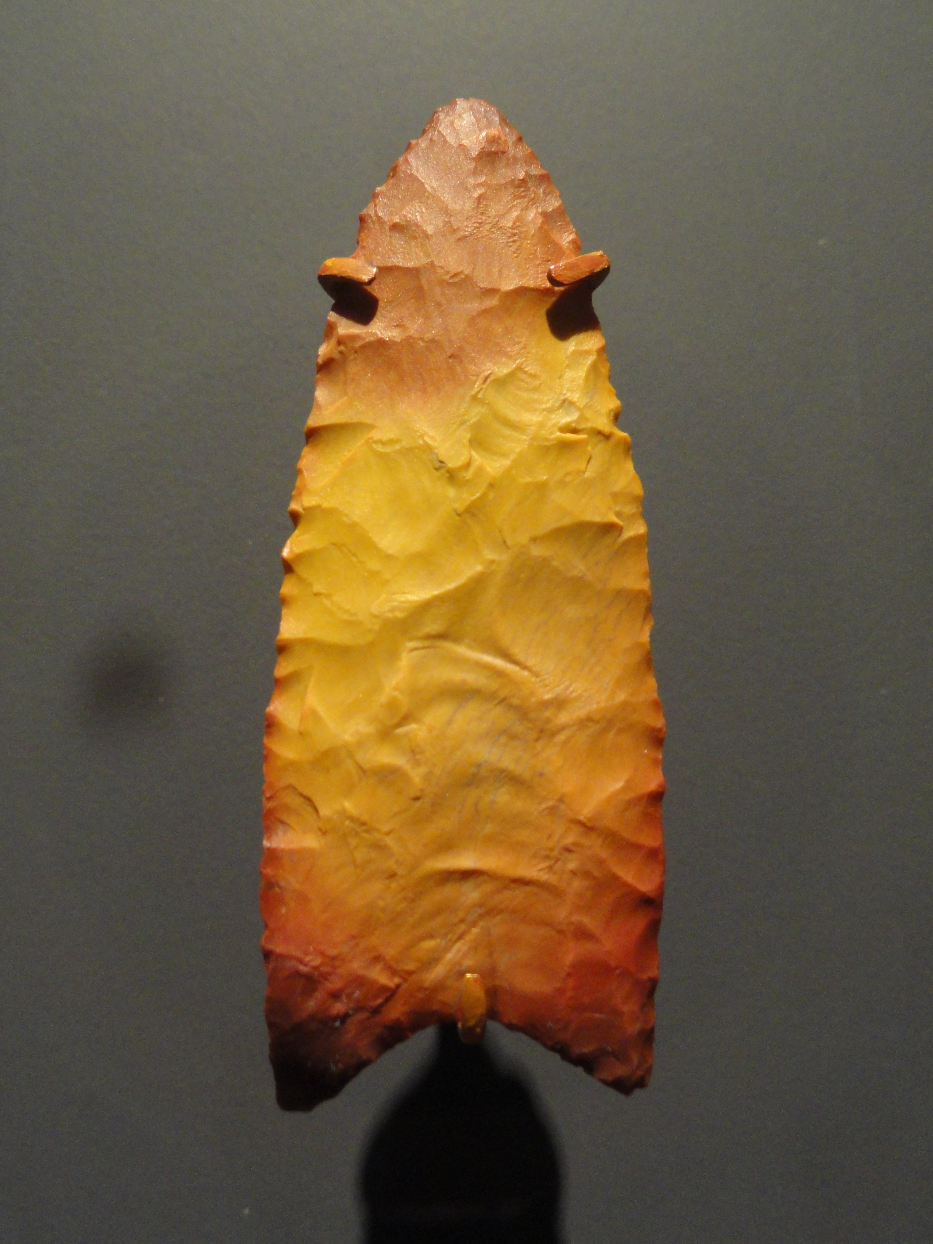
The stone tools left behind by Paleo-Indian and Archaic peoples are often the only surviving evidence of their presence, and the technology embedded in those tools tells a story of remarkable skill and far-reaching connections. Clovis points are characterized by their leaf shape, parallel or slightly convex sides, concave base, and the distinctive channel flake (or “flute”) removed from one or both faces to facilitate hafting. Folsom points refined this technology further: their flutes extend nearly the full length of the point, producing a remarkably thin cross-section that required extraordinary knapping precision (Archaeology Southwest, 2021).
The raw materials for these tools came from specific geological sources. The San Rafael Swell, which dominates the eastern half of Emery County, provided chert — a fine-grained siliceous rock ideal for knapping — from exposed formations that served as quarry sites throughout prehistory. Chert from the Swell has been identified in assemblages across the region, confirming that Emery County’s geological resources were part of a broader network of lithic procurement (eScholarship, “High Elevation Land-Use on the Northern Wasatch Plateau”).
As the Archaic period progressed, tool kits diversified. Ground stone tools — manos and metates for processing seeds and plant foods — appeared alongside the chipped-stone projectile points, signaling a fundamental shift in subsistence strategy from big-game specialization to broad-spectrum foraging (Utah History to Go, “Archaic Period”).
8.3 Seasonal Mobility & Campsite Patterns
Paleo-Indian and Archaic peoples did not settle in one place. They moved through the landscape in extended family groups, following the seasonal availability of food resources across elevational gradients — from the lowland desert floors of the San Rafael Swell and Green River corridor to the montane meadows of the Wasatch Plateau. This pattern of seasonal mobility, sometimes called a “seasonal round,” was the organizing principle of life for thousands of years.
During the Middle Archaic, this sense of place became highly refined. Archaeological evidence across eastern Utah suggests task-specific sites tied to precise seasonal windows: spring camps near emerging bitterroot and biscuitroot patches, summer camps at higher elevations for seed processing, autumn sites positioned for pronghorn hunting in valley bottoms and mule deer in the foothills, and winter shelters in protected canyon alcoves (Utah History to Go, “Eons of Foragers”). In Emery County, the dramatic topographic relief — from the Green River at roughly 1,220 meters (4,000 feet) to the highest elevations of the Wasatch Plateau above 3,050 meters (10,000 feet) — would have provided an unusually compressed seasonal round, allowing groups to access radically different ecological zones within a few days’ travel.
Campsite evidence in the broader region includes open-air lithic scatters (concentrations of stone tool debris indicating tool manufacture or maintenance), fire hearths, and the occasional pit feature. Rock shelters and cave overhangs provided more permanent shelter, and these sites tend to preserve organic materials — basketry, cordage, plant remains — that open-air sites do not.
8.4 Archaic Forager Traditions
The Archaic period in Utah spans roughly 8,000 to 2,000 years BP — an immense stretch of time that archaeologists sometimes call the “Desert Culture” or “Western Archaic.” Jesse D. Jennings, the father of Utah archaeology, defined the Desert Culture concept through his groundbreaking excavations at Danger Cave in western Utah during 1949–1956, establishing that a remarkably stable foraging adaptation persisted across the Great Basin and Colorado Plateau for millennia (Utah History Encyclopedia, “Archeology in Utah”).
The defining characteristics of the Desert Archaic include: nomadic movement in small family groups; reliance on a broad spectrum of plant and animal foods rather than specialization in any one resource; sophisticated basketry for gathering and storage; flaked-stone tools including atlatl dart points, scrapers, and knives; and ground-stone tools for seed and root processing. These peoples possessed an intimate knowledge of their environment — knowing not just where plants grew, but precisely when each species ripened and how to process it for maximum nutritional value.
Artifacts representing all four recognized phases of the Archaic culture — Early, Middle, Late, and Terminal — have been found within Emery County, documenting continuous human presence across the full span of this period (Utah Historical Quarterly, 1998). The county’s position at the junction of Great Basin and Colorado Plateau ecological zones made it a natural crossroads for peoples moving between these distinct environments.
Human Occupation of Emery County: A Deep Chronology
| Period | Approx. Years Ago | Key Signature |
|---|---|---|
| Paleo-Indian | 13,000–8,000 | Mammoth and giant bison hunting; Clovis and Folsom points |
| Early Archaic | 8,000–5,000 | Broad-spectrum foraging; ground stone tools appear |
| Middle Archaic | 5,000–3,000 | Refined seasonal rounds; San Rafael Swell chert in use |
| Late Archaic | 3,000–2,000 | Population growth; long-distance obsidian trade networks |
| Fremont transition | ~2,000–700 | Semi-sedentary settlements; maize cultivation begins |
The Archaic period alone spans 6,000 years — roughly the same length as all of recorded human history from ancient Sumer to today.
8.5 Subsistence Strategies
The transition from Paleo-Indian big-game hunting to Archaic broad-spectrum foraging was not a single event but a gradual process driven by the extinction of megafauna and the warming, drying climate of the early Holocene. As mammoths, giant ground sloths, and giant bison disappeared — a process largely complete by about 11,000 BP — human groups that had relied heavily on these animals were forced to diversify their diets.
In the Early Archaic, seed processing became increasingly important. At Cowboy Cave in nearby Wayne County, excavation layers thick with small seeds, chaff, baskets, and grinding tools indicate that the cave was used as a summer seed-processing camp. Other layers, containing sandals, animal hide, fur, and jackrabbit bones, suggest winter occupation focused on hunting small game (University of Utah Press, “Cowboy Cave”). This dual-season pattern — summer seed camps and winter hunting shelters — likely characterized occupation in the canyons and alcoves of Emery County as well.
By the Middle Archaic, subsistence had become a finely tuned system. People harvested pinyon nuts in autumn, Indian ricegrass and other grass seeds in summer, roots and tubers in spring, and hunted rabbits, marmots, muskrat, squirrel, grouse, geese, and fish opportunistically throughout the year. Bighorn sheep were hunted wherever terrain was rough enough to support them — a description that fits much of Emery County’s canyon country (Utah History to Go, “Eons of Foragers”).
During the Late Archaic (~3,000–2,000 BP), a return to wetter conditions expanded wetland habitats, and populations grew. People began aggregating in larger groups, a social shift that may have facilitated the communal processing of resources and the development of more complex social relationships — setting the stage for the semi-sedentary Fremont culture that would follow.
Design an Archaic Survival Kit
Archaic peoples carried everything they owned when moving between seasonal camps. Working as a family, list five items you could carry on your back to survive one week in a Utah canyon — with no modern technology allowed. Then compare your list to the actual Archaic toolkit: a mano (hand stone) and metate (grinding slab) for processing seeds; an atlatl for hunting large game; a tightly coiled basket for water carrying and seed gathering; a hand-drill fire kit; and a hide water bag. Where did your choices overlap? What did they think of that modern habits made you miss? For a hands-on test, grind a handful of dried grain or rice between two smooth rocks and estimate how long it would take to prepare a full meal. Archaic families did this every day, across thousands of years.
What you'll need:
Two smooth rocks (hand-sized), A handful of dried grain or rice, Paper and pencil for your list
8.6 Rock-Shelter & Open-Site Occupations
The geology of Emery County created ideal conditions for rock-shelter habitation. The Wingate, Kayenta, and Navajo sandstone formations that form the walls of canyons throughout the San Rafael Swell, Muddy Creek drainage, and Green River corridor often erode into overhangs and alcoves that provided natural shelter from sun, wind, and precipitation. These rock shelters were occupied repeatedly over thousands of years, building up stratified deposits that give archaeologists a layer-by-layer record of changing occupation patterns.
Cowboy Cave, located in the Horseshoe Canyon area just west of the Emery County line, exemplifies this pattern. Jesse Jennings’ 1975 excavation revealed deposits spanning from approximately 9,000 BP to the historic period. The earliest layers contained the Horseshoe Shouldered figurines — unfired clay artifacts dated to 5600–5000 BCE that represent the earliest known figurines in the American Southwest (ResearchGate, “Early Archaic Clay Figurines from Cowboy and Walters Caves”). These small objects, whose function remains debated, hint at a symbolic or ritual dimension of Archaic life that stone tools alone cannot reveal.
Open-air sites, by contrast, tend to be identified by surface scatters of lithic debitage (stone tool manufacturing waste), fire-cracked rock from hearths, and occasional ground-stone fragments. These sites are abundant across the San Rafael Swell and the benches above the Green River but are more difficult to date precisely because they lack the stratigraphic integrity of sheltered deposits. Many have been recorded by Bureau of Land Management archaeologists during cultural resource surveys, though relatively few have been formally excavated.

8.7 Environmental Change & Cultural Adaptation
The 12,000-year span covered in this chapter encompasses some of the most dramatic environmental changes in Earth’s recent history. The Pleistocene-Holocene transition (~11,700 BP) brought rising temperatures, shrinking lakes, retreating glaciers, and the extinction of most large mammals. For the human groups of Emery County, these changes were not abstract — they meant the disappearance of the animals their ancestors had hunted and the transformation of the plant communities they depended on.
In the eastern Great Basin, data from Danger Cave, Bonneville Estates Rockshelter, and Smith Creek Cave show that Paleo-Indian occupations were followed by gaps in human presence of at least 1,500 years, correlating with severe aridification beginning around 9,000 radiocarbon years ago (Goebel et al., 2007). Whether similar abandonment episodes occurred in Emery County is uncertain, but the Colorado Plateau’s varied topography — offering refugia at higher elevations even during the driest intervals — may have allowed some populations to persist where Great Basin lowland groups could not.
The Middle Holocene Altithermal (~7,500–4,500 BP) brought the warmest and driest conditions of the post-glacial period. Archaeological evidence across the region thins during this interval, suggesting reduced populations, contraction into better-watered areas, or shifts in settlement patterns that moved camps away from locations that archaeologists have surveyed. The subsequent Late Holocene cooling and moistening (~4,500 BP onward) correlates with increased archaeological visibility, more rock art production, and the emergence of the large Barrier Canyon Style pictograph tradition that is so prominent in the San Rafael Swell.
8.8 Radiocarbon Dating & Site Chronology
Radiocarbon dating, developed in the 1940s, revolutionized the study of Utah’s prehistory by enabling absolute dating of organic materials — charcoal, bone, shell, plant fibers, and other remains associated with human occupation. Jesse Jennings’ work at Danger Cave was among the first in the Great Basin to apply this technique systematically, establishing a framework that has been refined ever since (Utah History Encyclopedia, “Archeology in Utah”).
More recently, accelerator mass spectrometry (AMS) dating has allowed analysis of much smaller samples with greater precision, making it possible to date individual seeds, cordage fragments, or thin charcoal lenses within stratified deposits. At Cowboy Cave, AMS dating of a basket protruding from the cave floor in 2006 confirmed Jennings’ original estimate of ~9,000 BP for the earliest occupation, overturning a 1990s reassessment that had shortened the timeline to 8,000 BP (gjhikes.com, “Cowboy Cave”).
Within Emery County, formal radiocarbon dates are sparse in the published literature [needs additional sources]. Most chronological assignments rely on projectile-point typology — matching the style and size of stone points to established regional sequences — rather than direct radiometric dating. This is an area where future archaeological work could significantly advance understanding of the county’s deep past.
8.9 Social Networks & Exchange Systems
No Paleo-Indian or Archaic group in Emery County lived in isolation. Stone tool raw materials provide the clearest evidence of connections across large distances. Obsidian — volcanic glass prized for its razor-sharp edges and ease of knapping — does not occur naturally in Emery County but has been found in archaeological assemblages across the Colorado Plateau. X-ray fluorescence (XRF) spectrometry allows researchers to non-destructively match obsidian artifacts to specific volcanic sources, revealing networks of trade or direct procurement that sometimes spanned hundreds of kilometers (Bruker, “Obsidian and Stone Sourcing”).
Salina Canyon, which cuts through the Wasatch Plateau just west of Emery County, served as a natural travel and trade corridor between the eastern Great Basin and the northern Colorado Plateau. Through this route, peoples could access obsidian quarries in western Utah, the marshes and wetlands of the Sevier and Sanpete Valleys, and the chert quarries of the Wasatch Plateau and San Rafael Swell (eScholarship, “High Elevation Land-Use”). The presence of non-local materials in Emery County sites — and the distribution of San Rafael Swell chert in sites beyond the county — demonstrates that these exchange networks operated throughout the Archaic period.
Whether materials moved through direct procurement (groups traveling to quarries themselves), down-the-line trade (materials passed from group to group), or some combination remains an open question for most assemblages. What is clear is that the peoples of Emery County were embedded in social networks far larger than any single canyon or valley.
8.10 Mortuary Practices & Symbolic Behavior
Evidence for mortuary practices during the Paleo-Indian and Archaic periods in eastern Utah is extremely limited, a reflection of both the small, mobile populations involved and the sensitivity of burial data under the Native American Graves Protection and Repatriation Act (NAGPRA, 1990). Where burials have been documented in the broader Great Basin and Colorado Plateau — typically flexed interments in rock shelters or shallow pits — they suggest that the dead were treated with care, sometimes accompanied by grave goods including tools, ornaments, and ochre.
The Horseshoe Shouldered clay figurines from Cowboy Cave (5600–5000 BCE) offer a tantalizing glimpse into the symbolic world of Early Archaic peoples. These unfired clay objects, shaped with distinctive squared shoulders, are the earliest figurines known from the American Southwest. Their function is debated — possible interpretations include hunting magic, fertility symbolism, or ritual offerings — but their very existence demonstrates that Archaic foragers invested time and thought in activities beyond immediate subsistence (ResearchGate, “Cowboy Cave Revisited”).
The Barrier Canyon Style pictographs, while likely dating to the Late Archaic rather than the periods covered in the earliest sections of this chapter, represent perhaps the most spectacular evidence of symbolic and possibly ceremonial behavior in the region. The large, haunting anthropomorphic figures — often described as “starry-eyed mummies” — painted in alcoves throughout the San Rafael Swell and Horseshoe Canyon suggest a rich tradition of ritual expression (see Chapter 12 for detailed treatment of rock art).

Clay figurines recovered from Cowboy Cave near the Emery County border — dated to 5600–5000 BCE — are the oldest known figurines in the entire American Southwest, predating the Egyptian pyramids by more than two thousand years. Their purpose is still debated: hunting ritual, fertility symbol, or something else entirely. The people who shaped them left no written explanation.
— ResearchGate, 'Early Archaic Clay Figurines from Cowboy and Walters Caves'
8.11 Lithic Raw Material Sourcing & Trade
The geology of Emery County (see Chapter 2) created a landscape rich in toolstone. The San Rafael Swell exposes formations spanning hundreds of millions of years, and several of these contain chert nodules and beds suitable for stone tool production. Chert from Permian and Pennsylvanian-age formations on the Swell was a locally available, high-quality raw material that Paleo-Indian and Archaic knappers exploited extensively.
Beyond local chert, the presence of obsidian, quartzite, and other non-local materials in regional assemblages testifies to procurement networks that extended well beyond the county. Obsidian from sources in the Thomas Range and Black Rock Desert of western Utah, and possibly from sources in Idaho and Wyoming, has been identified in Colorado Plateau sites through XRF analysis. Chalcedony, jasper, and petrified wood from various geological exposures supplemented the toolkit.
The study of lithic raw material sourcing is an active area of research. Modern analytical techniques — including XRF, instrumental neutron activation analysis (INAA), and petrographic thin-section analysis — continue to refine understanding of which geological sources were exploited, how materials moved across the landscape, and how procurement strategies changed over time. For Emery County specifically, systematic sourcing studies of San Rafael Swell chert [needs additional sources] could provide important new data on local quarry use and regional exchange patterns.
8.12 Tribal Collaborations & Site Stewardship
The archaeological record of Paleo-Indian and Archaic peoples is not merely an academic subject — it represents the ancestral heritage of living Native American communities. The Ute Indian Tribe of the Uintah and Ouray Reservation, whose traditional territory encompasses much of eastern Utah including Emery County, maintains a deep connection to these ancient landscapes and the cultural materials they contain.
The Native American Graves Protection and Repatriation Act (NAGPRA), enacted in 1990, requires federal agencies and institutions receiving federal funds to consult with lineal descendants and affiliated tribes regarding the repatriation of human remains, funerary objects, sacred objects, and objects of cultural patrimony. In Utah, the Division of Indian Affairs’ Native American Remains Review Committee provides a state-level framework for consultation on remains discovered on state and private lands (Utah Division of Indian Affairs).
Institutions such as the Natural History Museum of Utah and the USU Eastern Prehistoric Museum in Price hold significant archaeological collections from the region and maintain active NAGPRA compliance programs. The Ute Indian Tribe has ongoing repatriation interests: records indicate that institutions have not yet made available for return the remains of at least 1,500 Native Americans from counties within the tribe’s area of interest (ProPublica NAGPRA Database).
For the Encyclopedia of Emery County, engaging respectfully with tribal perspectives on the deep past is not optional — it is essential. The archaeological interpretations presented in this and subsequent chapters represent one way of understanding the ancient record. Indigenous oral traditions, ceremonial knowledge, and lived connections to ancestral landscapes offer complementary perspectives that enrich and sometimes challenge the archaeological narrative. Future editions of this work should incorporate tribal review of these chapters, and readers are encouraged to visit the USU Eastern Prehistoric Museum and support tribal cultural preservation efforts.
Sources
- Archaeology Southwest (2021). “What’s the Point: Folsom Technology, 12,800 to 10,200 BP.”
- Britannica. “Clovis Complex” and “Folsom Complex.”
- Cambridge Core. “The Columbian Mammoth, Mammuthus columbi, from the Wasatch Mountains of Central Utah.”
- eScholarship. “High Elevation Land-Use on the Northern Wasatch Plateau.”
- Goebel, T., et al. (2007). “The Paleoindian Occupations at Bonneville Estates Rockshelter, Danger Cave, and Smith Creek Cave.” Texas A&M CSFA.
- ProPublica. “NAGPRA Database — Ute Indian Tribe Repatriation Records.”
- ResearchGate. “Cowboy Cave Revisited” (2022); “Early Archaic Clay Figurines from Cowboy and Walters Caves.”
- Sanpete County. “The Huntington Mountain Mammoth.”
- University of Utah Press. “Cowboy Cave” (Jesse D. Jennings monograph).
- USU Eastern Prehistoric Museum. Archaeological and paleontological collections.
- Utah Division of Indian Affairs. “Native American Remains Review Committee.”
- Utah Geological Survey. “Utah’s Wildlife in the Ice Age.”
- Utah Historical Quarterly, Vol. 66, No. 3 (1998). “History Written on the Land in Emery County.”
- Utah History Encyclopedia. “Archeology in Utah.”
- Utah History to Go. “The Paleoindian Period”; “Archaic Period”; “Eons of Foragers: The Archaic Period.”
Proposed Maps & Figures
- Timeline graphic: Paleo-Indian → Early Archaic → Middle Archaic → Late Archaic → Fremont transition, with key sites and climate events
- Map: Key archaeological sites in and near Emery County (Cowboy Cave, Barrier Canyon/Horseshoe Canyon, Nine Mile Canyon, Huntington Mammoth site, San Rafael Swell quarry areas)
- Projectile point typology diagram: Clovis, Folsom, and Archaic dart-point styles found in the region
- Huntington Mammoth reconstruction: Photo of skeleton at USU Eastern Prehistoric Museum
- Seasonal round diagram: Schematic showing elevational movement and seasonal resource use
- Trade route map: Salina Canyon corridor, obsidian/chert source areas, and exchange networks
Proposed Tables
- Chronological framework: Period names, date ranges, diagnostic artifacts, key sites, subsistence patterns
- Megafauna assemblage: Species found at Huntington Canyon site with dates and significance
Stand with the Mammoth
- Your subject
- The Huntington Mammoth skeleton at USU Eastern Prehistoric Museum
- Where to find it
- What to look for
- The story you're telling
- This mammoth walked the Wasatch Plateau roughly 11,220 years ago, during the same era the first Paleo-Indian hunters moved through these canyons. Your photo connects you across that span of time.
Share your photo with #EmeryEncyclopedia
Ancient Emery County at the USU Eastern Prehistoric Museum
- □ The Huntington Mammoth skeleton — estimate how many times taller it stands than you do.
- □ A Clovis or Folsom projectile point — find the channel flake (flute) running down the center face.
- □ A mano and metate set — imagine carrying these grinding stones from camp to camp across the seasons.
- □ An atlatl or atlatl dart — how would you aim this at a 10,000-pound mammoth?
- □ A photograph or reproduction of Barrier Canyon Style rock art — spot the tall anthropomorphic figures rendered in dark red ochre.
- □ The site map showing where the Huntington Mammoth was found — locate Huntington Canyon.
Share your finds! #EmeryEncyclopedia
Prehistoric Emery County: A One-Day Field Loop
Eleven thousand years of human presence, condensed into one driving day
On the ground
At the museum, spend 1.5–2 hours with the Huntington Mammoth and Archaic-period collections. At Buckhorn Wash, stand back from the panel to take in its full scale — the figures reach six feet tall. Do not touch the rock art; skin oils accelerate deterioration. The overhanging sandstone sheltering the panel is the same alcove geometry that drew Archaic peoples to canyon camps thousands of years ago. Report any vandalism to the BLM Price Field Office. These sites remain part of the living heritage of the Ute Indian Tribe and other Indigenous communities.
See also: Chapter 9 (Fremont Culture) · Chapter 12 (Rock Art)