Part 1 · Foundations
Flora Zones
Plant communities from high-elevation forests to desert shrublands: ecology and species across elevational gradients.
Ch05 — Flora Zones
Walk west from the floor of Castle Valley on any spring afternoon and the landscape reshapes itself around you. At the valley floor, greasewood and shadscale give way to a gentle rise of sagebrush; the sagebrush thins to pinyon and juniper as the slope steepens; those woodlands yield to Gambel oak and ponderosa pine where the air cools; and the pines give way, finally, to the Engelmann spruce and subalpine fir of the Wasatch Plateau, wrapped in cloud. In the space of twenty miles and 6,000 feet of elevation, a traveler passes through five distinct plant communities — each as ecologically complete as a biome unto itself. This chapter maps those communities: where they occur, what species define them, how they respond to fire and drought, and why Emery County functions as one of the more ecologically compressed transects in the Intermountain West.
5.1 Floristic Provinces & Elevation Gradient
Emery County straddles the ecological hinge between the Great Basin and Colorado Plateau, and its plant communities march upslope in distinct, climate-driven bands. Below approximately 4,500 feet, saline valley floors and benches support salt-desert shrubs — shadscale, fourwing saltbush, and greasewood — adapted to high soil salinity and minimal precipitation. Between approximately 4,500 and 6,000 feet, the sagebrush steppe emerges, dominated by basin big sagebrush and Indian ricegrass, providing winter forage for mule deer and pronghorn. The pinyon-juniper belt (approximately 5,500–7,500 feet) cloaks rocky uplands, where two-needle pinyon and Utah juniper form woodlands with Gambel oak understory. From approximately 7,000 to 9,000 feet, mixed-conifer forests of ponderosa pine, Douglas-fir, and white fir transition to subalpine Engelmann spruce and subalpine fir groves above approximately 9,500 feet. Alpine meadows above approximately 10,500 feet on the county’s highest ridges — East Mountain, the county high point, reaches 10,743 feet — host cushion plants and late-summer wildflowers. These floristic zones reflect temperature lapse rates (~3°F per 1,000 feet), precipitation gradients, and soil chemistry, making Emery County a living transect of Intermountain West botany (Welsh et al. 2003).
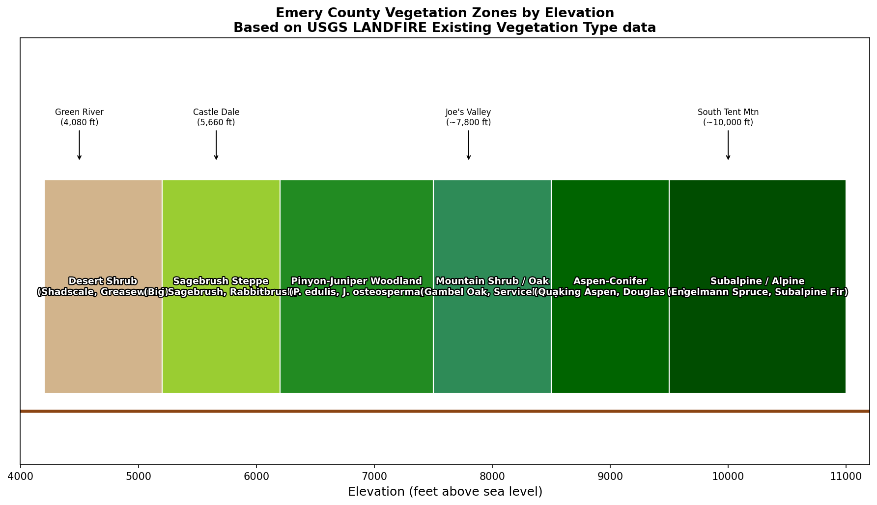
Emery County's Vegetation Zones
| Zone | Elevation | Key Species |
|---|---|---|
| Salt-desert shrublands | Below 4,500 ft | Shadscale, greasewood, fourwing saltbush |
| Sagebrush steppe | 4,500–6,000 ft | Basin big sagebrush, Indian ricegrass |
| Pinyon–juniper woodlands | 5,500–7,500 ft | Two-needle pinyon, Utah juniper |
| Mountain brush & montane forest | 7,000–9,000 ft | Gambel oak, ponderosa pine, Douglas-fir |
| Subalpine & alpine | Above 9,000 ft | Engelmann spruce, subalpine fir, alpine meadows |
Each zone reflects a ~3°F temperature drop and increasing precipitation per 1,000 feet of elevation — the same gradient that shapes the county's water supply (Chapter 3) and climate (Chapter 4).
5.2 Salt-Desert Shrublands
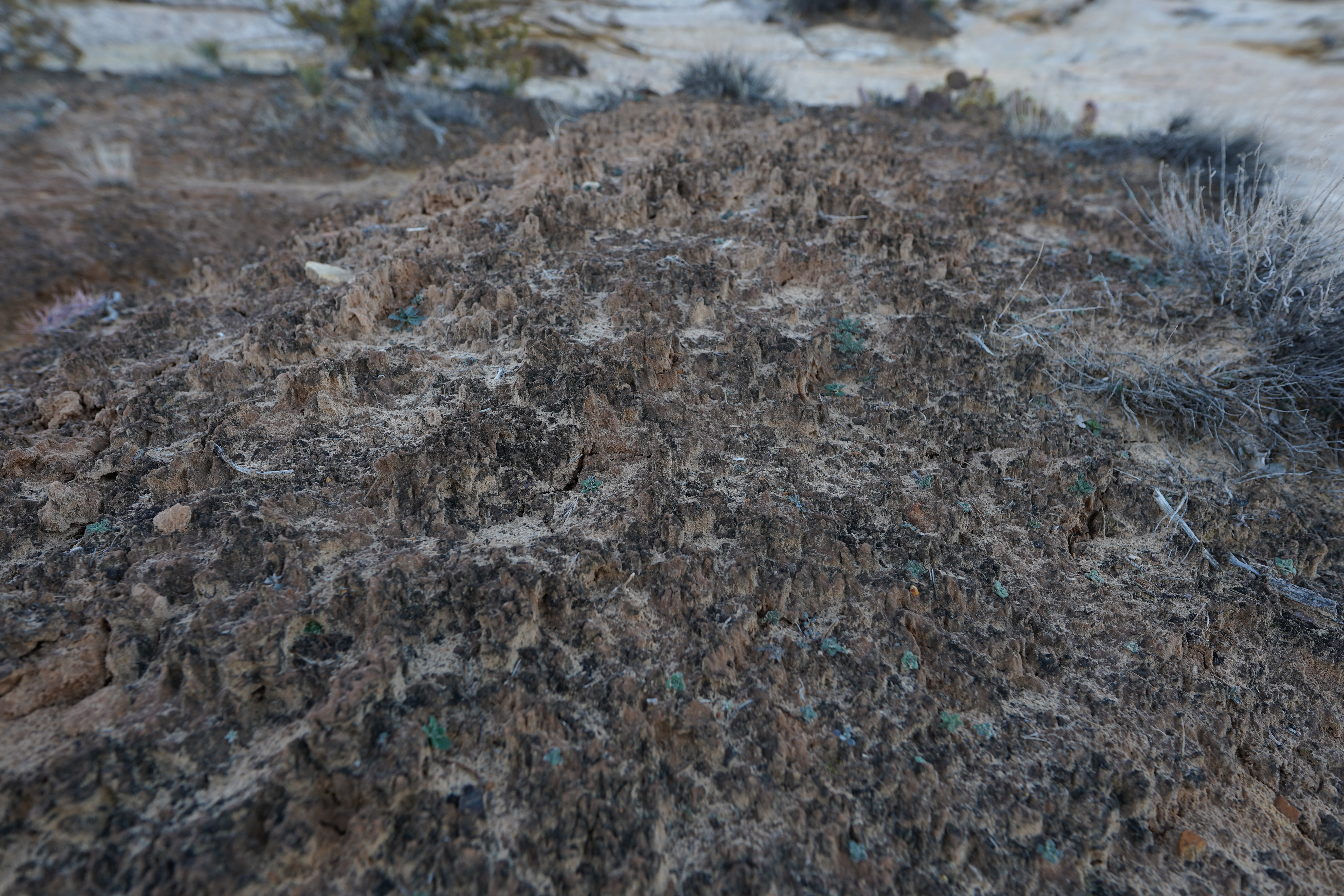
Salt-desert shrublands occupy the lowest benches and basin floors of Emery County, typically below 4,500 feet elevation, where soil salinity and seasonal drought stress select for highly salt-tolerant (halophytic) vegetation. Dominant species include Atriplex confertifolia (shadscale), Sarcobatus vermiculatus (greasewood), Atriplex canescens (fourwing saltbush), and Pleuraphis jamesii (sand dropseed), forming open, low-growing mosaics on calcic and gypsic soils. Soil salinities range from 2 to over 10 dS/m, reflected in broad leaf succulence and specialized salt-excretion bladder cells that give fourwing saltbush its distinctive metallic sheen (USDA NRCS 2007). Cryptobiotic soil crusts — composed of cyanobacteria, lichens, and mosses — stabilize surface sediments, reduce erosion, and enhance nitrogen fixation, though they are highly vulnerable to trampling and off-road vehicle traffic. Seasonal moisture from infrequent storms triggers ephemeral wildflower displays of desert primrose (Oenothera deltoides) and blazing star (Mentzelia decapetala). Wildlife use includes essential winter forage for pronghorn (Antilocapra americana) and mule deer (Odocoileus hemionus), as well as critical habitat for the horned lizard (Phrynosoma platyrhinos). Management challenges involve balancing grazing pressure, controlling invasive saltcedar (Tamarix ramosissima), and restoring crust integrity after disturbance. Recent BLM restoration trials use native seed mixes and microbiotic-crust inocula to accelerate recovery on degraded flats.
The dark, lumpy, rough-looking crust you see on undisturbed desert soil in Emery County is alive. Cryptobiotic soil crust — a community of cyanobacteria, lichens, and mosses — stabilizes loose soils, fixes nitrogen from the air, and may take 50 to 250 years to recover from a single footstep. Off-road vehicles can destroy in seconds what decades built. The BLM's reminder in canyon country: 'don't bust the crust.' When hiking on desert flats, stay on established trails, slickrock, or dry stream channels rather than stepping on the dark, lumpy patches between plants.
— Bureau of Land Management; USDA NRCS
5.3 Sagebrush Steppe Transition
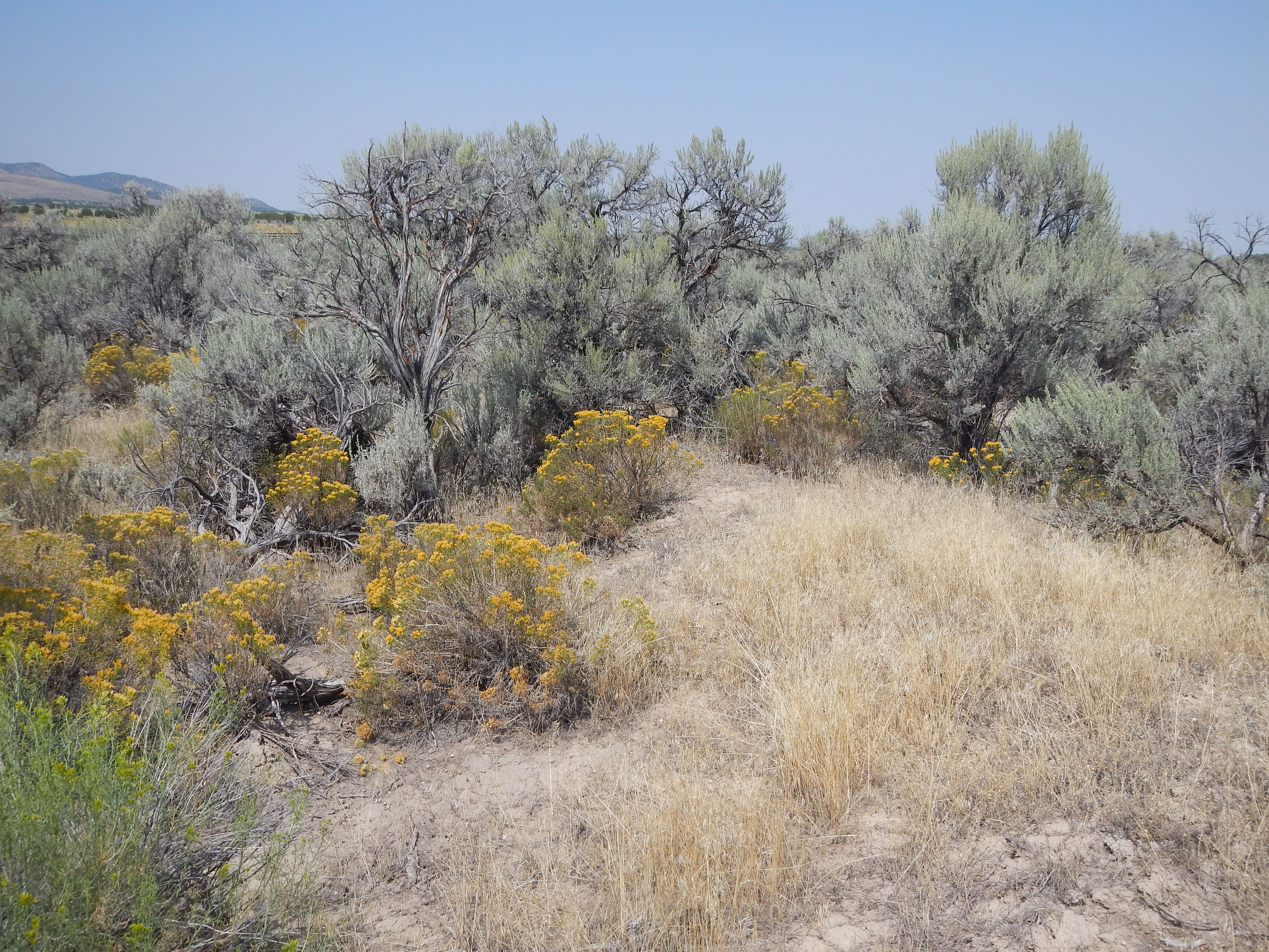
Between approximately 4,500 and 6,000 feet, Emery County’s sagebrush steppe forms a mosaic between lower-elevation salt deserts and upland pinyon–juniper woodlands. Dominated by Artemisia tridentata subspecies — principally basin big sagebrush and Wyoming big sagebrush — this zone features an understory of perennial bunchgrasses such as Indian ricegrass (Achnatherum hymenoides), needle-and-thread grass (Hesperostipa comata), and Sandberg bluegrass (Poa secunda). Annual precipitation ranges from 8 to 12 inches, with cold winters and warm, dry summers influencing phenology. Soils are typically well-drained loams to sandy loams, formed on alluvial fans and colluvial slopes, with a thin organic horizon.
Fire historically maintained open stands at 60–100-year intervals, though regional estimates range from 40 to 150 years depending on site moisture and fuel accumulation (Miller & Tausch 2001). Invasive cheatgrass (Bromus tectorum) has compressed fire return intervals to 10–20 years in some areas, fundamentally altering species composition and habitat quality. Wildlife — including pronghorn, mule deer, and greater sage-grouse — depend on sagebrush for forage, cover, and breeding grounds; sage-grouse in particular require large, intact sagebrush stands for spring lekking. Cultural uses by Numic-speaking peoples include medicinal and ceremonial gathering of sagebrush and associated forbs. Management challenges center on balancing grazing, invasive-species control, and prescribed burning to sustain plant diversity and ecosystem services.
5.4 Pinyon–Juniper Woodlands
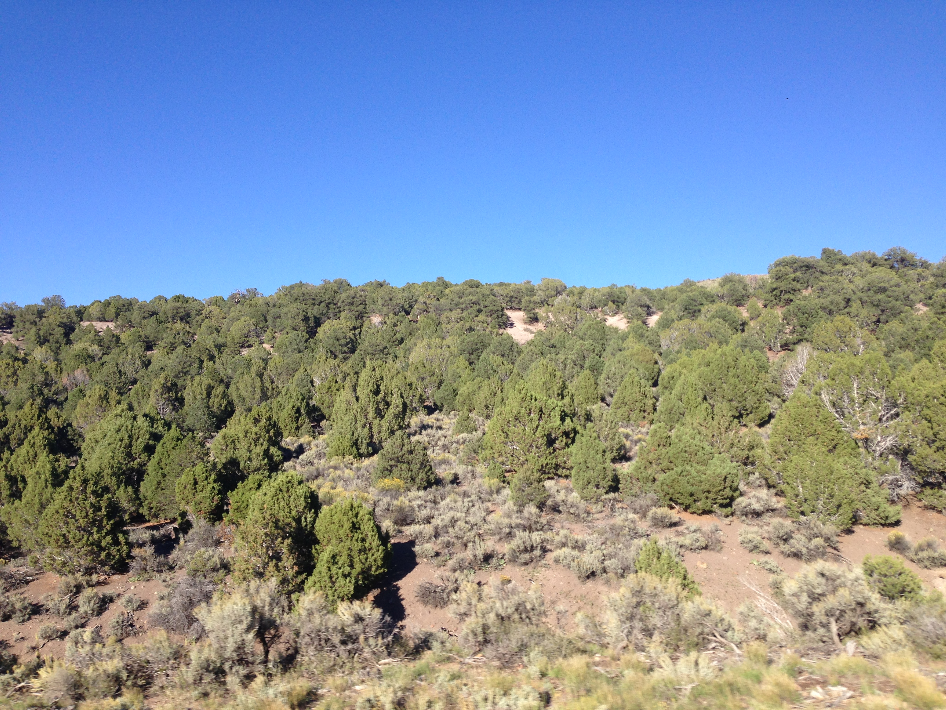
Pinyon–juniper woodlands dominate mid-elevations in Emery County, roughly between 5,500 and 7,500 feet, forming the largest vegetation belt by area. The overstory typically comprises Pinus edulis (two-needle pinyon) and Juniperus osteosperma (Utah juniper), often mixed with scattered Juniperus scopulorum (Rocky Mountain juniper) on north-facing slopes. Understory grasses and forbs include Indian ricegrass (Achnatherum hymenoides), needle-and-thread grass (Hesperostipa comata), and gooseberry maple (Acer glabrum) seedlings in mesic microsites. Pinyon nuts are a keystone resource for wildlife and people, with mast years every 2–5 years driven by specific climatic cues (Chambers & Wisdom 2009). Woodland structure varies with soil depth and aspect: shallow soils on slickrock yield open stands with stunted trees, while deeper colluvial soils support dense canopies reaching 20 feet tall. These woodlands play a critical role in soil stabilization, snow capture, and wildlife habitat for pinyon jays, mule deer, and black bears. Recent climate warming and bark beetle outbreaks have stressed some stands, prompting management discussions on controlled thinning and native grass restoration.
Pinyon pines produce bumper crops of nutritious nuts only once every two to five years — 'mast years' triggered by specific combinations of temperature and rainfall that scientists still do not fully understand. In a mast year, pinyon jays, Clark's nutcrackers, black bears, and mule deer all gorge on the harvest, and human communities across the Colorado Plateau have relied on pinyon nuts for thousands of years. The unpredictability is not a flaw: it overwhelms seed predators, ensuring that more nuts survive to germinate than would be possible if the crop were reliable every year.
5.5 Mountain Brush Zone
Mountain brush stands occur primarily between 7,000 and 9,000 feet, where moisture availability and cooler temperatures support fire-adapted shrub communities. Dominated by Gambel oak (Quercus gambelii), serviceberry (Amelanchier utahensis), and mountain mahogany (Cercocarpus ledifolius), these thickets occupy canyon rims, midslope benches, and sheltered draws. Gambel oak forms dense, multi-stemmed clonal thickets that resprout vigorously after fire, while serviceberry provides early-season fruit and nectar resources. Mountain mahogany thrives on well-drained gravels and talus slopes, anchoring soils with deep roots and offering critical winter browse for mule deer. Understory grasses — such as Poa fendleriana (muttongrass) and Festuca idahoensis (Idaho fescue) — and forbs like Penstemon clutei (Clute’s penstemon) add structural diversity and seasonal color. Fire regimes historically cycled every 20–40 years, maintaining a mosaic of age classes; however, fire suppression and pinyon–juniper encroachment have altered brush density and composition (Bartos & Mueggler 1981). Ethnobotanical uses by Ute and Paiute peoples include oak acorn grinding and mountain mahogany stem weaving. Conservation efforts focus on restoring natural fire regimes and controlling conifer encroachment to preserve shrubland biodiversity.
5.6 Ponderosa Pine & Mixed Montane Forests
Emery County’s mid-to-upper montane woodlands, spanning roughly 7,500 to 9,000 feet, are dominated by Pinus ponderosa var. scopulorum (Rocky Mountain ponderosa pine), Pseudotsuga menziesii (Douglas-fir), and stands of Abies concolor (white fir) in cooler, north-facing coves and canyon bottoms. These forests develop on deep, well-drained loamy soils derived from Navajo Sandstone and Mancos Shale parent material, supporting a diverse understory of Mahonia repens (creeping barberry), Amelanchier alnifolia (serviceberry), Carex geyeri (elk sedge), and Lupinus argenteus (silvery lupine). Historical fire-return intervals in ponderosa-dominated stands ranged from 50 to 100 years, creating the open, park-like structure characteristic of healthy montane pine forests (USDA Forest Service Intermountain Region). Fire suppression and bark beetle outbreaks in recent decades have increased fuel loads and susceptibility to high-severity fires. Ponderosa pine’s thick, plated bark and deep root system confer resilience to drought and low-intensity surface fire, making it a keystone species for forest management planning. These woodlands support Clark’s nutcracker, black bear, and mule deer; ponderosa pine nuts were historically harvested by Numic peoples as a seasonal food source. Effective restoration approaches combine controlled burns, mechanical thinning, and native bunchgrass seeding.
5.7 Subalpine Spruce–Fir & Alpine Meadows
Above approximately 9,000 feet on Emery County’s high ridges and plateaus, the subalpine zone transitions from dense Engelmann spruce–subalpine fir forests to windswept alpine meadows. Picea engelmannii (Engelmann spruce) and Abies lasiocarpa (subalpine fir) dominate sheltered north-facing slopes and canyon floors, supporting understories of Vaccinium globulare and a rich lichen carpet. As elevation and exposure increase, trees assume krummholz forms — stunted, wind-pruned growth that merges into discontinuous stands before giving way to open ground entirely.
Above tree line (approximately 10,500 feet), alpine meadows emerge as mosaics of cushion plants (Oreoxis alpina), sedges (Carex hoodii), and spring-blooming forbs including Aquilegia caerulea and tufted hairgrass. Seasonal snowpack persists into July in snowdrift hollows, shaping soil moisture and extending flowering windows. SNOTEL monitoring sites across the Wasatch Plateau document a regional trend of declining peak snow-water equivalent and earlier melt-out dates, consistent with phenological advances of 4–6 days in alpine bloom onset observed across the Colorado Plateau over recent decades (Utah Snow Survey, NRCS). Warmer summer temperatures have facilitated spruce beetle outbreaks, documented at 9,200 feet in 2018, which have stressed mature fir stands. Conservation strategies emphasize limiting foot traffic via designated trails, monitoring snowpack trends, and mapping krummholz boundary shifts as an indicator of climate change.
5.8 Riparian Corridors & Wetlands
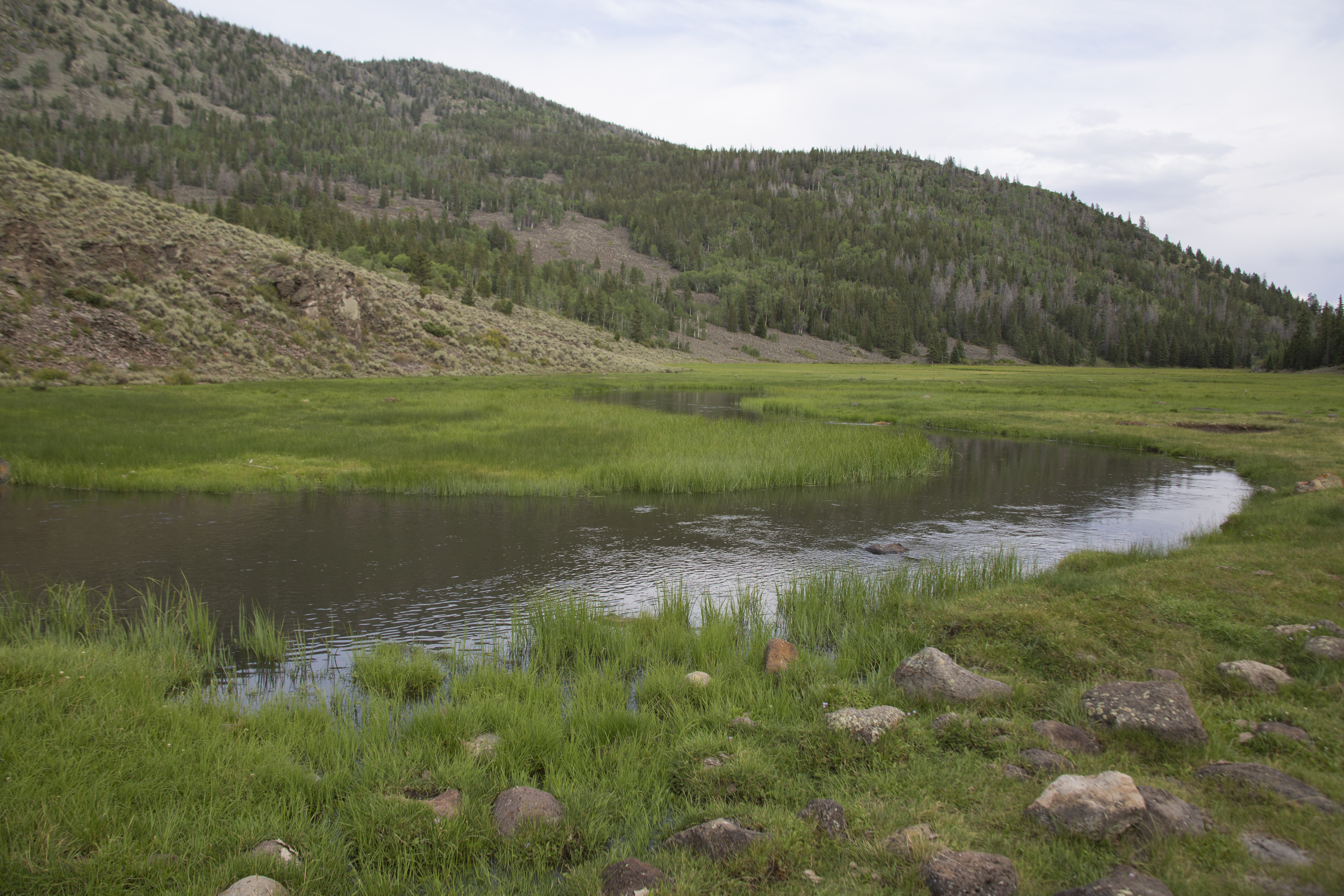
Emery County’s riparian corridors thread lush vegetation through its predominantly arid landscapes, clustering along perennial streams — most notably the Green, San Rafael, and Price rivers — and at spring-fed seeps. Dominant canopy species include Fremont cottonwood (Populus fremontii), narrowleaf willow (Salix exigua), and box elder (Acer negundo), forming gallery forests that stabilize banks and moderate water temperatures. Understory layers of sedges (Carex spp.), rushes (Juncus spp.), and native grasses thrive in seasonally saturated soils, while downstream reaches host emergent marshes dominated by cattails (Typha latifolia) and bulrushes (Schoenoplectus spp.). Beavers (Castor canadensis) play a keystone role: their dams raise water tables, expand wetland mosaics, and enhance habitat complexity for amphibians and riparian birds (Stevens & Meretsky 2008). Hyporheic exchange zones — where surface water infiltrates channel gravels — sustain baseflows and maintain water quality during dry spells.
Riparian zones provide critical wildlife corridors, buffer flood peaks, and filter agricultural sediment. However, invasive saltcedar (Tamarix ramosissima) and Russian olive (Elaeagnus angustifolia) threaten native communities by altering hydrology, increasing evapotranspiration, and shading out cottonwood regeneration. Restoration initiatives by the BLM and local watershed councils focus on invasive removal, native replanting, and beaver-assisted water retention (BLM 2020).
5.9 Rare, Endemic & Relict Species
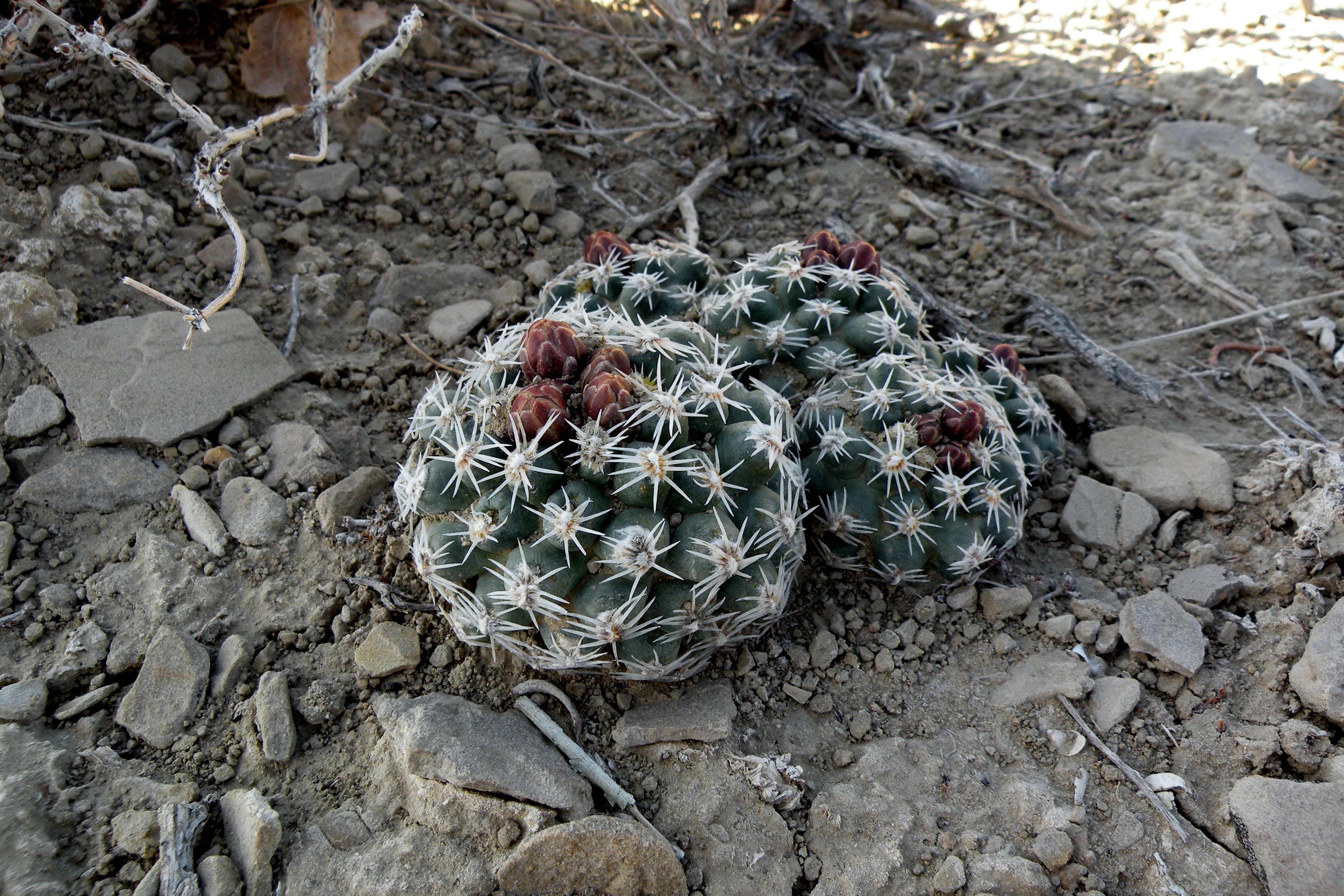
Emery County harbors a remarkable assemblage of rare, endemic, and relict plant species that testify to its unique geology and microclimates. The San Rafael cactus (Pediocactus despainii), confined to calcic outcrops within the San Rafael Swell, produces vibrant magenta blooms in spring and is listed as endangered under the federal Endangered Species Act (U.S. Fish & Wildlife Service 2010). Wright’s fishhook cactus (Sclerocactus wrightiae) thrives on sandy terraces along the Green River, its hooked spines nearly camouflaged against the pale substrate. The Cisco milkvetch (Astragalus despainii) is restricted to Mancos Shale benches in the county, adapted to thin, seasonally saturated soils. Alpine relicts such as Polemonium pulcherrimum persist in snowdrift hollows above 10,000 feet — Pleistocene survivors in cool refugia that have persisted as the climate warmed around them. Additional special-status taxa include Frankenia jamesii and Astragalus coccineus, each tied to saline or gypsum-rich seeps. Population counts for Pediocactus despainii number in the hundreds of known individuals, and specialized habitat needs make these species highly vulnerable to grazing, road dust, and climate shifts. Conservation measures by the Utah Natural Heritage Program and BLM include population monitoring, seed banking, and invasive saltcedar removal to protect spring habitats.
Find the Rarest Cactus in the Swell
- Your subject
- San Rafael cactus (Pediocactus despainii) in bloom — a small, solitary cactus roughly the size of a tennis ball, with vibrant magenta flowers, growing on calcic sandstone outcrops in the San Rafael Swell
- Where to find it
- San Rafael Swell, Emery County — consult the Utah Natural Heritage Program or BLM Price Field Office (435-636-3600) for current bloom-season access guidance; specific site coordinates are managed to reduce collection pressure on this endangered species
- What to look for
- Visit in late April to early May and scan weathered limestone and calcic sandstone at low to mid elevations. The plant is easy to overlook when not in bloom — the magenta flowers give it away first. Photograph the plant in context with its substrate to document the specialized rock habitat.
- The story you're telling
- Pediocactus despainii exists nowhere else on earth. It is one of the rarest cacti in North America. Every documented observation submitted to iNaturalist or directly to the Utah Natural Heritage Program contributes to population monitoring and helps researchers track how climate change is affecting its tiny range.
- Composition tip
- Do not step off established trails or disturb the cryptobiotic soil crust around the plant — the microhabitat is as fragile as the species itself. Use a telephoto lens or phone zoom rather than approaching closely.
Share your photo with #EmeryEncyclopedia
5.10 Seasonal Wildflower Calendar
Emery County’s high-desert through subalpine landscapes come alive each spring in an elevational wave of wildflower blooms driven by snowmelt and monsoon moisture. Phenological observations reveal a consistent altitudinal progression:
- April–May (below 5,000 ft): Desert ephemerals like desert paintbrush (Castilleja chromosa), sand violet (Viola pedatifida), and prickly pear (Opuntia polyacantha) carpet lower valley benches.
- June (5,000–7,000 ft): Pinyon–juniper understories burst with Indian paintbrush (Castilleja angustifolia), silvery lupine (Lupinus argenteus), and desert marigold (Baileya multiradiata).
- July (7,000–9,000 ft): Montane meadows host blazing star (Mentzelia multiflora), Colorado columbine (Aquilegia caerulea), and butterfly milkweed (Asclepias tuberosa).
- August (above 9,000 ft): Alpine zones peak with Degener’s penstemon (Penstemon degeneri), fringed gentian (Gentiana fremontii), and alpine phlox (Phlox austromontana).
Interannual variability — first bloom dates shifting 5–7 days earlier over recent decades — reflects a regional warming and altered-snowpack signal documented across the Colorado Plateau, consistent with iNaturalist citizen-science datasets and phenology literature (Utah Native Plant Society 2022). This bloom calendar underpins ecotourism scheduling, pollinator habitat mapping, and ongoing citizen-science monitoring programs.
Start a Wildflower Phenology Journal
Choose three spots at different elevations you can revisit — a valley roadside, a mid-elevation canyon trail, and a mountain meadow. In April or May, record the date and which wildflowers are blooming at each spot, with photographs. Return every two to four weeks through summer. By August you will have documented the full elevational wave described in Section 5.10. For a deeper challenge: look up historical observations for the same areas on iNaturalist and compare your bloom dates to records from ten years ago. Climate scientists have found that bloom dates across the Colorado Plateau have shifted five to seven days earlier over the last three decades — your journal can become part of the long-term record.
What you'll need:
Notebook and pencil or phone camera, Utah wildflower field guide (Utah Native Plant Society), GPS coordinates or note the nearest road junction for each site, Free iNaturalist app for photo logging and species identification
5.11 Fire Ecology & Post-Disturbance Succession
Fire is a fundamental ecological process shaping Emery County’s plant communities, with historical regimes varying sharply by vegetation zone. In sagebrush steppe (4,500–6,000 feet), low-intensity surface fires historically returned every 40–100 years — a range reflecting site-specific variation in fuel accumulation, moisture, and topography (Miller & Tausch 2001). Pinyon–juniper woodlands experienced mixed-severity burns at roughly 100–200-year intervals, creating a mosaic of age classes. In mountain brush (7,000–9,000 feet), periodic crown fires at 60–120-year intervals cleared Gambel oak thickets, facilitating recruitment from persistent root crowns.
Post-disturbance succession begins with opportunistic forbs and grasses — particularly Indian ricegrass (Achnatherum hymenoides) and lupines (Lupinus spp.) — which stabilize soils and fix nitrogen. Shrub resprouters like Gambel oak and serviceberry regenerate vegetatively from their root systems, while seeders such as mountain mahogany establish on exposed mineral soil. Subalpine forests recover slowly over centuries, with Engelmann spruce and subalpine fir seedlings establishing in nurse logs and sheltered microsites. Fire exclusion since the early 20th century has increased fuel loads across all zones, leading to more severe, stand-replacing events that challenge natural resilience. Management approaches now emphasize prescribed burns, mechanical thinning, and native bunchgrass seeding to restore historical fire dynamics and support biodiversity under changing climate conditions.
5.12 Invasive Species & Land-Management Responses
Invasive plant species have transformed disturbed and riparian habitats across Emery County, creating cascading changes in fire regimes, soil chemistry, and wildlife habitat. Cheatgrass (Bromus tectorum) dominates post-disturbance sagebrush steppe and pinyon–juniper understories, creating fine fuel loads that compress fire return intervals from decades to years and prevent native shrub recovery (Novak et al. 2011). Saltcedar (Tamarix ramosissima) colonizes spring seeps and streambanks, raising evapotranspiration rates, increasing soil salinity, and shading out native cottonwood and willow regeneration (Di Tomaso 1998). Musk thistle (Carduus nutans) invades road cuts and overgrazed meadows at mid-elevations, reducing forage quality for livestock and wildlife.
Management responses include targeted herbicide applications timed to pre-seed germination windows, mechanical removal of saltcedar followed by native willow and cottonwood replanting, and strategic grazing rotations to suppress cheatgrass while promoting perennial native grasses. Restoration success is measured through long-term monitoring of species cover, fuel loads, and fire return intervals, as documented in BLM and NRCS trial plots across the county and region. Understanding the life-history traits of invasive species, combined with adaptive management frameworks that adjust strategies as monitoring data accumulate, is essential for sustaining native plant communities under the additional pressure of a warming, drying regional climate.
Flora Zone Explorer
- □ A patch of cryptobiotic soil crust — look for the dark, lumpy, rough-textured surface on undisturbed desert soil away from roads and trails. Do NOT step on it.
- □ A two-needle pinyon with a cone or fresh nut — look for small, rounded trees on rocky slopes at mid-elevation. Two needles bundled together at the base = pinyon pine.
- □ A Gambel oak thicket — multi-stemmed oaks with distinctive lobed leaves on canyon rims or north-facing slopes between 7,000 and 9,000 ft. In fall, look for acorns.
- □ A Fremont cottonwood near water — look for triangular, toothed leaves and deeply furrowed silver-gray bark along the San Rafael River, Huntington Creek, or any perennial stream.
- □ A wildflower you can identify by name at any elevation. Photograph it and submit your observation to iNaturalist.
Share your finds! #EmeryEncyclopedia
The Wildflower Gradient: Valley Floor to Alpine Meadow
A half-day drive from SR-10 near Ferron to the Wasatch Plateau traces five vegetation zones and drops roughly 30°F in temperature.
On the ground
At low elevation: crush a saltbush leaf and notice the salt crystals from its specialized excretion glands. In the sagebrush zone: crush a leaf to intensify the unmistakable scent. In the pinyon-juniper belt: in a mast year, the ground may be littered with nut shells. In mountain brush: listen for the raucous social calls of pinyon jays moving through Gambel oak. At the top (~10,000 ft): count the flower species in a one-meter square of alpine meadow — a healthy alpine meadow can support fifteen or more species in a single square meter.
See also: Chapter 4 — Climate & Weather (temperature lapse rates and precipitation zones) · Chapter 6 — Fauna (wildlife communities of each vegetation zone)
Sources
- Welsh, S. L., N. D. Atwood, S. Goodrich, and L. C. Higgins. A Utah Flora. 4th ed. Provo: Brigham Young University Press, 2003.
- USDA NRCS. Soil Survey of Emery County Area, Utah. Washington, D.C.: Natural Resources Conservation Service, 2007.
- Utah Geological Survey. Ecological Classification System for Utah. Salt Lake City: UGS, 2020.
- Miller, R. F., and R. J. Tausch. “The role of fire in juniper and pinyon woodlands: A descriptive analysis.” In Invasive Plant Workshop: The Role of Fire in Noxious Weed Management, USDA Forest Service Miscellaneous Publication No. 11, edited by E. D. McArthur, W. K. Ostler, and C. L. Wambolt, 15–30. Ogden, UT: Rocky Mountain Research Station, 2001.
- Chambers, J. C., and M. J. Wisdom. “Priority research and management issues for the imperiled Great Basin of the western United States.” Restoration Ecology 17(5) (2009): 707–714.
- Bartos, D. L., and W. F. Mueggler. Gambel Oak in Utah and Colorado — Its Response to Management. USDA Forest Service Research Paper INT-252. Ogden, UT: Intermountain Forest and Range Experiment Station, 1981.
- Stevens, L. E., and V. J. Meretsky, eds. Aridland Springs in North America: Ecology and Conservation. Tucson: University of Arizona Press, 2008.
- Bureau of Land Management. Emery County Springs & Riparian Inventory. Price, UT: BLM Price Field Office, 2020.
- U.S. Fish & Wildlife Service. Recovery Plan for Pediocactus despainii (San Rafael Cactus). Denver: USFWS Mountain-Prairie Region, 2010.
- Utah Natural Heritage Program. Rare Plant List for Utah. Salt Lake City: Utah Division of Wildlife Resources, 2022.
- Novak, S. J., et al. “Ecology and management of cheatgrass (Bromus tectorum L.) in the Intermountain West.” Rangeland Ecology & Management 64(6) (2011): 543–553.
- Di Tomaso, J. M. “Impact, biology, and ecology of saltcedar (Tamarix spp.) in the southwestern United States.” Weed Technology 12(2) (1998): 326–336.
- Utah Native Plant Society. Utah Wildflower Calendar. Salt Lake City: UNPS, 2022. utahnativeplants.org.
- USDA NRCS, Utah Snow Survey. SNOTEL Network — Wasatch Plateau Stations. snotel.wcc.nrcs.usda.gov.
- USDA Plants Database. National Plant Data Team. Greensboro, NC: USDA NRCS. plants.usda.gov.