Part 2 · Peoples
Numic Expansion
The Numic peoples — ancestors of the Ute, Southern Paiute, and Shoshone — and their arrival on the Colorado Plateau after the Fremont decline.
Ch10 — Numic Expansion
Sometime after A.D. 1000, the people who had farmed corn along Muddy Creek and painted figures on the walls of Barrier Canyon began to fade from the archaeological record. Into the landscape they left behind came a new wave of peoples — mobile, adaptable, and linguistically distinct — whose descendants would become the Ute, Southern Paiute, and Shoshone nations. Their arrival on the Colorado Plateau, part of a broader population movement scholars call the Numic expansion, reshaped the human geography of what is now Emery County for centuries before European contact and continues to shape it today.
10.1 Proto-Numic Origins & Linguistic Evidence
The story of the Numic peoples begins far to the west. Linguists trace the Uto-Aztecan language family — one of the largest in North America, encompassing everything from the Aztec language Nahuatl to the Hopi of northern Arizona — to a homeland in the vicinity of Death Valley and southern California. Roughly two thousand years ago, this language family began diversifying into the nine major groups known today (Lamb, 1958; Fowler, 1972).
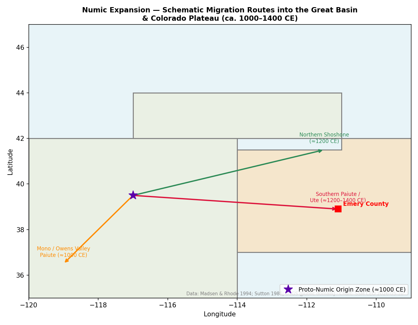
The Numic branch of Uto-Aztecan is divided into three sub-branches: Western Numic (ancestral to the Shoshone and Comanche), Central Numic (ancestral to the Ute and Southern Paiute), and Southern Numic (ancestral to the Kawaiisu). For most of their early history, these groups remained on the western and southern margins of the Great Basin. Then, roughly a thousand years ago, they began a rapid eastward and northward movement that carried them across the basin and onto the neighboring Colorado Plateau (Madsen and Rhode, 1994).
The primary archaeological marker for this migration is a distinctive basketry technology — plain and diagonal open and close twined work with an up-to-the-right twist direction — that differs markedly from the coiled basketry of the earlier Fremont peoples (Adovasio, 1986). By approximately A.D. 1000, Numic foragers in eastern and southern Nevada were aware of the Fremont and Ancestral Puebloan farmers to their east, and some scholars believe the two populations coexisted for a time before the farming cultures declined (Utah History to Go, “Late Prehistoric Period”).
Modern scholars caution against reading this transition as a simple wave of conquest. The older model of a rapid, linear “Numic Spread” does not do justice to the complex processes of ethnogenesis, language change, cultural borrowing, and shifting alliances that accompanied the movement. What emerged on the Colorado Plateau by the thirteenth and fourteenth centuries was not a single, uniform culture but a constellation of related peoples adapted to the diverse environments they encountered (Utah History to Go, “The Late Prehistoric Millennium”).
All Numic languages — Ute, Southern Paiute, Shoshone, Comanche, and several others — descend from a single ancestral language spoken near Death Valley roughly 2,000 years ago. From that single origin, Numic-speaking peoples spread across one of the largest geographic footprints of any language family in pre-Columbian North America, from the Mojave Desert to Wyoming and from the California Sierra Nevada to the Great Plains. The Utes who called Castle Valley 'Tompin-con-tu — rock house land' were part of this great linguistic diaspora.
— Lamb (1958); Fowler (1972)
10.2 Ute Migration Routes into Central Utah
Of the Numic-speaking groups, the Ute peoples established the most significant and enduring presence in the Emery County region. Archaeological and ethnohistoric evidence places ancestral Utes in southwestern Colorado and southeastern Utah by approximately A.D. 1300. By the sixteenth century, Ute territory had expanded to encompass some 225,000 square miles — from Fillmore, Utah, on the west to Colorado Springs, Colorado, on the east, and from Baggs, Wyoming, in the north to Abiquiu, New Mexico, in the south (Callaway, Janetski, and Stewart, 1986).
Within this vast domain, several bands made seasonal use of the Castle Valley and San Rafael region that now constitutes Emery County. The San Pitch band (Sanpits Utes) ranged through the valleys west of the Wasatch Plateau and made regular seasonal forays into Castle Valley to exploit its diverse resources. The Sheberetch band likely visited the eastern portions of the county near the Green River corridor, while the Weeminuche may have ranged into the southern desert areas along the San Rafael Swell (UEN, “Emery County”).
The Utes had their own name for this landscape. They called Castle Valley “Tompin-con-tu” — rock house land — a reference to the dramatic sandstone formations and cliff dwellings that characterize the region (I Love History, “Emery County”). That name speaks to an intimate familiarity with the terrain, a knowledge built over generations of seasonal movement through its canyons, mesas, and valleys.

10.3 Paiute Settlement Patterns & Adaptations
The Southern Paiute, who share a Central Numic linguistic ancestry with the Ute, occupied the southern and southwestern portions of present-day Utah. Their territory extended from the Virgin River drainage across the arid lands south of the Colorado Plateau. While the Southern Paiute homeland lay primarily south and west of Emery County, the boundaries between Paiute and Ute territory were fluid, and some overlap likely occurred in the southern reaches of the San Rafael desert.
The Southern Paiute developed sophisticated strategies for surviving in some of North America’s most arid environments. They became expert gatherers of seeds, roots, and desert plants, and they managed their landscape through controlled burning to encourage the growth of useful species. Their knowledge of water sources — seeps, springs, and seasonal watercourses — was encyclopedic and essential to survival (Knack, 2001).
Direct evidence of sustained Paiute presence within present-day Emery County is limited in the archaeological record, and further research is needed to clarify the extent of their activities in the region. What is clear is that the boundaries drawn on modern maps did not exist for these peoples; the landscape was a continuous web of resources, relationships, and movement routes that transcended the lines later imposed by Euro-American surveyors.
10.4 Shoshone Movements & Intertribal Contacts
The Western and Northern Shoshone, speakers of the Western Numic branch, occupied the northern Great Basin and portions of northern Utah. The Eastern Shoshone ranged far onto the Great Plains. While Shoshone territory lay primarily north of the Emery County region, the Gosiute — a Western Shoshone subgroup adapted to the harsh desert environments of western Utah — demonstrate how Numic peoples could thrive in even the most marginal landscapes.
Intertribal contacts among Numic-speaking peoples were frequent and multifaceted. Shared linguistic roots facilitated communication across band and tribal boundaries, and seasonal gatherings for communal hunts, trade, and ceremony brought groups together from across the region. The Great Basin and Colorado Plateau were not divided into rigid ethnic territories but constituted a dynamic social landscape where peoples moved, mixed, and maintained overlapping networks of kinship and exchange.
Archaeological evidence of Shoshone-specific activity within Emery County remains thin, and distinguishing Shoshone from Ute material culture in the archaeological record is challenging given their shared Numic heritage. Future research, particularly analysis of lithic sources and ceramic traditions, may help clarify the extent of Shoshone presence in the region.
10.5 Seasonal Mobility & Resource Round
Before the transformative acquisition of horses in the late seventeenth century, Numic peoples in the Emery County region practiced a carefully calibrated seasonal round that exploited the diverse ecological zones available within a relatively compact area. The Wasatch Plateau to the west rises above 10,000 feet; Castle Valley sits at roughly 5,500 to 6,000 feet; and the San Rafael desert descends below 4,500 feet. This elevational gradient offered a remarkable diversity of plant and animal resources within a day or two of travel.
Winter camps were typically established in sheltered lower-elevation locations — the protected valleys and canyon alcoves of Castle Valley and the San Rafael drainage — where juniper and pinyon woodlands provided fuel and some food. As spring arrived and snow retreated up the mountains, bands moved to middle elevations to harvest early greens, roots, and the first emerging game. Summer found them at higher elevations on the plateau, where deer, elk, and mountain sheep were abundant and temperatures were moderate. Autumn brought the critical pinyon harvest, when entire bands gathered in the pinyon-juniper woodlands to collect and process the protein-rich nuts that would sustain them through winter (Callaway, Janetski, and Stewart, 1986).
Communal rabbit drives, documented among Great Basin Numic peoples, may also have taken place in the sagebrush flats of Castle Valley and the desert margins. These drives were social as well as economic events, bringing together multiple family groups for cooperative hunting.
Numic Word-Walk
Before your walk, visit the Ute Indian Tribe's website (utetribe.com) or the University of Utah's digital language resources to find five to ten Ute words for things you will encounter outdoors — canyon, river, mountain, spring, cottonwood, sage, deer, rock. Write them on a card to carry with you. As you walk, say each word aloud when you reach the thing it names. After the walk, discuss: how does learning even a few words in another language change how you pay attention to a place? Languages encode ways of knowing the land — what might a Ute word for a particular plant or landform reveal about how that resource was used?
What you'll need:
A printed or written word list, Optional: a pocket notebook to record what you notice
10.6 Basketry, Hide Preparation & Material Culture
Material culture among the Numic peoples of the Colorado Plateau reflected both their Great Basin heritage and their adaptation to new environments. Basketry was the preeminent art form — used for gathering, storage, cooking (using hot-stone boiling), and even water transport. The distinctive Numic twining technique set their work apart from the coiled baskets of the earlier Fremont peoples, and changes in basketry technology serve as one of the primary archaeological markers for the Numic transition (Adovasio, 1986).
By approximately A.D. 1000, Numic foragers had begun borrowing pottery technology from their Fremont and Ancestral Puebloan neighbors, creating their own simplified versions long before the farming cultures disappeared. This ceramic tradition — typically plain, utilitarian brownware — represents a practical adaptation rather than a wholesale cultural adoption (Utah History to Go, “The Late Prehistoric Millennium”).
Clothing among pre-horse Numic groups reflected the demands of the arid environment: sagebrush-bark aprons and breechcloths in warm weather, supplemented by rabbit-skin robes in winter. The rabbit-skin robe was an ingenious textile — strips of rabbit hide were twisted into cordage and woven into a warm, lightweight blanket. After the acquisition of horses, hide-working skills expanded as Ute bands adopted elements of Plains material culture, including tipis, beaded clothing, and horse gear.
Rock art continued to be produced by Numic peoples, though in styles distinct from the earlier Barrier Canyon and Fremont traditions. Identifying specifically Numic rock art panels in Emery County remains an active area of archaeological research.
10.7 Band Organization & Leadership Structures
Ute social organization was built on a foundation of flexibility and decentralized authority — qualities well suited to the demands of a mobile, hunter-gatherer existence. The basic social unit was the band, comprising several residential groups (demes) that united under a leader. This leader was typically an elder male who had demonstrated prowess as a hunter and wisdom in decision-making, though leadership was earned rather than inherited (Callaway, Janetski, and Stewart, 1986).
The Ute leadership structure was notably non-pyramidal. No single individual governed all aspects of community life. Instead, natural leaders emerged for their particular talents — in war, hunting, medicine, or spiritual matters. Their counsel was respected but not binding; group decisions were reached through discussion and consensus. Councils met at the chief’s residence, and both women and men other than chiefs were permitted to attend, giving the decision-making process a broadly participatory character (Every Culture, “Ute Sociopolitical Organization”).
Over time, approximately twelve major Ute bands coalesced, each associated with a particular territory and named for a geographic feature, a resource, or a characteristic practice. Band leaders directed seasonal activities — coordinating movements, allocating hunting grounds, mediating disputes — while family-level leaders managed the daily affairs of their households.
This flexible structure served the Ute well for centuries. It allowed bands to expand, contract, merge, and separate in response to changing environmental and social conditions — an adaptive capacity that would be severely tested by the arrival of Euro-American settlers in the nineteenth century.
Major Ute Bands with Territory Near Emery County
| Band name | Core territory | Relationship to Emery County |
|---|---|---|
| San Pitch (Sanpits) | Sevier and Sanpete valleys, western Castle Valley | Primary seasonal users of Castle Valley |
| Sheberetch | Eastern Utah, San Rafael Swell, Green River corridor | Seasonal use of southern and eastern Emery County |
| Weeminuche | SE Utah, SW Colorado (Four Corners area) | Occasional use of southern desert margins |
| Uintah | Uintah Basin, eastern Utah | Eastern Emery County and Green River approaches |
Band territories were not rigid boundaries but overlapping seasonal ranges. All four bands are part of what became the Ute Indian Tribe of the Uintah and Ouray Reservation, the present-day governing body for Northern Ute peoples.
10.8 Trade Networks & Intertribal Exchange
Long before European contact, the peoples of the Colorado Plateau participated in extensive trade networks that connected the Great Basin, the Southwest, the Great Plains, and the Pacific Coast. Obsidian from volcanic sources in present-day Idaho and Nevada, marine shell from the California coast, turquoise from the Southwest, and bison hides from the Plains all circulated through these networks, carried by travelers who followed established routes across the region.
The acquisition of horses after the Pueblo Revolt of 1680, when large numbers of Spanish horses became available, transformed Ute society profoundly. Mounted bands could range farther, hunt more effectively, transport larger loads, and project military power over greater distances. The Ute quickly became among the most accomplished horsemen on the Colorado Plateau, and their expanded mobility drew them into new trade relationships — and new conflicts — with Plains peoples such as the Comanche, Cheyenne, and Arapaho (UEN, “Northern Utes”).
The Utes also became important middlemen in the Spanish colonial trade economy. Around 1750, Spanish authorities in New Mexico forged alliances with Ute groups to protect mission settlements and develop commerce. Latino traders from New Mexico began traveling into Utah along what became known as the Old Spanish Trail — a roughly 700-mile route from Santa Fe through present-day Moab and on to Los Angeles. Along this route, Ute and Navajo traders exchanged furs, hides, horses, and captives for European tools, weapons, and trade goods (I Love History, “The Spanish Empire”).
The slave trade was a particularly dark dimension of this exchange. Utes captured members of other tribal groups — often Paiutes — and traded them to the Spanish for horses and goods. This practice, while deeply troubling from a modern perspective, reflected the complex power dynamics and economic pressures that all peoples of the region navigated during the colonial era. It is important to acknowledge this history without reducing any people’s story to a single dimension.
10.9 Early Euro-American Encounters & Impacts
The first documented European entry near the Emery County region came with the Dominguez-Escalante Expedition of 1776, which passed through portions of central Utah while seeking a route from Santa Fe to Monterey, California. The expedition’s journals describe encounters with Ute peoples and provide some of the earliest written descriptions of the landscape and its inhabitants.
In the early nineteenth century, fur trappers and mountain men — including figures like Antoine Robidoux, who established trading posts in the Uinta Basin — deepened Euro-American contact with Ute bands. These interactions were initially commercial, but they introduced new goods, diseases, and pressures that began to alter traditional lifeways.
The arrival of Mormon settlers in the Salt Lake Valley in 1847, and their subsequent expansion into central and eastern Utah in the 1850s through 1870s, brought a more fundamental disruption. Settlers occupied valley lands that had been critical to the Ute seasonal round, fenced water sources, and introduced livestock that competed with native game. The friction between an expanding agricultural society and a mobile hunting people generated decades of conflict.
The most significant armed conflict was the Black Hawk War (1865–1872), in which Ute, Paiute, Navajo, Apache, and other tribal fighters — drawn from more than a dozen groups — under the leadership of Antonga Black Hawk conducted raids on Mormon settlements across central and southern Utah, including communities in or near present-day Emery County. The war was rooted in broken promises, encroachment on traditional lands, and the desperation of peoples being pushed to the margins of their own homeland.
10.10 Treaty Negotiations & Territorial Loss
The legal dispossession of Ute lands in Utah unfolded through a series of federal actions that combined coercion, broken promises, and bureaucratic indifference. In 1861, President Abraham Lincoln signed an executive order establishing the Uintah Valley Reservation in the eastern part of Utah Territory — a response to Mormon pressure to remove Ute peoples from the most desirable agricultural lands.
The Treaty of Spanish Fork, negotiated on June 8, 1865, at the Spanish Fork Indian Farm, formalized the intended removal. Under its terms, the Utes were required to relinquish possession of all lands in Utah Territory except the Uintah Valley reservation. In return, they were promised annuities of $25,000 per year for ten years, $20,000 for the following twenty years, and $15,000 for the final thirty years (totaling roughly $1,000,000 over sixty years, though the exact annual breakdown in the primary treaty text warrants further verification). The elderly leader Sowiette expressed the anguish of his people, stating their desire not to sell their land. Brigham Young, present at the negotiations, advised the Ute leaders that these were the best terms they would receive (Larson, “Uintah Dream,” BYU Studies Quarterly).
The treaty’s aftermath was even more bitter than its terms. Congress never ratified the agreement, and the promised annuities were never paid. Yet in the succeeding years, most Utah Utes were nonetheless removed to the Uintah Reservation — dispossessed without even the compensation that the unratified treaty had promised. The Uintah and Ouray Reservation, as it exists today, lies in parts of seven Utah counties, including a small portion of Emery County.
10.11 Reservation Era & Assimilation Policies
The removal to the Uintah Basin marked the beginning of a profoundly difficult era for the Ute people. The reservation lands, while vast, were arid and far less productive than the mountain valleys, plateaus, and canyon country that had sustained Ute bands for centuries. Traditional seasonal rounds were disrupted, and the people were expected to adopt sedentary farming on land poorly suited to agriculture.
Federal assimilation policies compounded the loss of land with attacks on Ute culture itself. The Dawes General Allotment Act of 1887 divided communal reservation lands into individual parcels, opening “surplus” lands to non-Indian settlement and drastically reducing the reservation’s extent. Government-run boarding schools removed Ute children from their families, forbade them from speaking their language, and sought to erase their cultural identity — a policy now widely recognized as a form of cultural destruction.
The Indian Reorganization Act of 1934 offered a partial reversal, ending allotment and encouraging tribal self-governance. The Ute Tribal Business Committee, established in 1937, became the formal governing body of the Northern Ute tribe. However, the termination era of the 1950s brought new threats to Ute sovereignty, as federal policy shifted toward dissolving the government-to-government relationship with tribes altogether. The Ute people resisted termination, and the policy was ultimately abandoned, but not before further damage was done to tribal resources and governance.
10.12 Modern Tribal Sovereignty & Cultural Revitalization
Today, three bands — the Whiteriver, Uncompahgre, and Uintah — compose the Northern Ute tribe (formally, the Ute Indian Tribe of the Uintah and Ouray Reservation). In 1986, the U.S. Supreme Court denied certiorari in Utah v. Ute Indian Tribe, affirming earlier holdings (the Ute III line of cases) that allotment legislation had not diminished reservation status — a decision that strengthened Ute sovereignty in eastern Utah. The jurisdictional picture was complicated seven years later by Hagen v. Utah (1993), in which the Court found that portions of the reservation had been diminished; the boundaries of tribal legal authority have been the subject of continuing litigation and negotiation ever since.
Cultural revitalization is a central priority for the modern Ute nation. Language preservation programs work to teach the Ute language to younger generations, recognizing that language is inseparable from cultural identity and worldview. The Bear Dance, held each spring, and the Sun Dance remain central ceremonial events that connect contemporary Ute people to their ancestors and to the land. Traditional arts — basket weaving, beadwork, pottery, and silversmithing — continue to be practiced, taught, and celebrated as living traditions rather than museum curiosities.
Economic development on the reservation has focused on the tribe’s energy resources, particularly oil and natural gas, as well as agriculture and tribal enterprises. These ventures reflect a pragmatic approach to building a sustainable economic base while maintaining cultural values and environmental stewardship.
For the people of Emery County, the Numic legacy is written across the landscape they inhabit. The rock art panels in Buckhorn Wash and Black Dragon Canyon, the archaeological sites along Muddy Creek and the San Rafael River, the very name Castle Valley — Tompin-con-tu, rock house land — all testify to a deep human history that preceded European settlement by centuries and that continues in the sovereign Ute nation today. Understanding and respecting that history is not merely an academic exercise; it is an act of acknowledging the full story of the land on which the county’s communities were built.
Sources
- Adovasio, J. M. “Prehistoric Basketry.” In Handbook of North American Indians, Vol. 11: Great Basin. Washington, D.C.: Smithsonian Institution, 1986.
- Callaway, Donald, Joel Janetski, and Omer C. Stewart. “Ute.” In Handbook of North American Indians, Vol. 11: Great Basin. Washington, D.C.: Smithsonian Institution, 1986.
- Fowler, Catherine S. “Some Ecological Clues to Proto-Numic Homelands.” In Great Basin Cultural Ecology: A Symposium, edited by Don D. Fowler. Reno: Desert Research Institute, 1972.
- Knack, Martha C. Boundaries Between: The Southern Paiutes, 1775–1995. Lincoln: University of Nebraska Press, 2001.
- Lamb, Sydney M. “Linguistic Prehistory in the Great Basin.” International Journal of American Linguistics 24, no. 2 (1958): 95–100.
- Larson, Gustive O. “Uintah Dream: The Ute Treaty—Spanish Fork, 1865.” BYU Studies Quarterly 14, no. 3 (1974).
- Madsen, David B., and David Rhode, eds. Across the West: Human Population Movement and the Expansion of the Numa. Salt Lake City: University of Utah Press, 1994.
- Utah Division of Indian Affairs. “Ute Indian Tribe of the Uintah & Ouray Reservation.” indian.utah.gov.
- Utah History to Go. “The Late Prehistoric Millennium.” historytogo.utah.gov.
- Utah History to Go. “A History of Utah’s American Indians,” Chapters 5–6. historytogo.utah.gov.
- UEN. “Emery County.” Utah History Encyclopedia. uen.org.
- I Love History. “Emery County.” ilovehistory.utah.gov.
- I Love History. “The Spanish Empire: Trade and Transformation.” ilovehistory.utah.gov.
- Every Culture. “Ute — Sociopolitical Organization.” everyculture.com.
Proposed Maps & Figures
- Map: Numic Migration Routes — Proto-Numic homeland (Death Valley area) with arrows showing expansion eastward across the Great Basin and onto the Colorado Plateau, ca. A.D. 1000–1300.
- Map: Ute Band Territories — Major Ute bands superimposed on modern county boundaries, highlighting San Pitch, Sheberetch, and Weeminuche presence in and near Emery County.
- Map: Old Spanish Trail — Trade route from Santa Fe through Moab area, showing its proximity to Emery County.
- Timeline: Numic Peoples in Emery County — From A.D. 1000 (arrival) through 1986 (Supreme Court sovereignty decision).
Proposed Tables
- Major Ute Bands and Their Territories — Band name, territory description, relationship to Emery County region.
- Key Treaty and Policy Events — Date, event, impact on Ute peoples in central Utah.
Ute Trade-Route Planner
Using a printed USGS topographic map of Emery County (free at apps.nationalmap.gov), design a travel route for a Ute family in September 1830, moving from a summer hunting camp on the high Wasatch Plateau (above 9,000 feet) to a winter camp in the protected canyon bottoms near the Green River (below 4,500 feet). Consider: Which passes would still be open in late September? Where would you find reliable water along the route? What food sources would be available — pinyon nuts, deer, rabbit? How many miles could a family on foot realistically cover per day? Mark your route with colored pencil, then discuss what you would carry and what you might cache for the return trip in spring.
What you'll need:
A printed USGS topographic map of Emery County, Colored pencils or markers, Optional: a compass to estimate distances
Photograph a Pinyon-Juniper Woodland in Autumn
- Your subject
- A stand of pinyon pine (Pinus edulis) with visible cones, in October or November when cones are ripe
- Where to find it
- What to look for
- The story you're telling
- The same pinyon groves you photograph have sustained human communities for at least 10,000 years — Archaic gatherers, Fremont farmers who supplemented corn with wild foods, and Numic-speaking peoples who organized entire seasonal rounds around the autumn harvest. Pine nuts provided roughly 3,000 calories per pound and stored through winter. Your photograph connects you to that unbroken thread.
Share your photo with #EmeryEncyclopedia
Northern Ute Powwow — Fort Duchesne, Uintah County
The closest major public event connecting the Castle Valley region to living Ute culture
On the ground
The Northern Ute Powwow is a public event welcoming respectful visitors. Watch dancing and drumming from designated spectator areas. Purchase directly from tribal artisans — beadwork, jewelry, and traditional arts. Ask before photographing individuals; follow all posted event guidelines. The Ute people are a living nation with contemporary governance, language programs, and cultural institutions. This event is a reminder that the history in Chapter 10 continues today.
See also: Chapter 11 (Spanish and Mexican Period) · Chapter 15 (Settlement Era)