Part 5 · Field Guide
Wildlife Watching
A field guide to wildlife observation across Emery County's three habitat zones - the Wasatch Plateau high country, the San Rafael Swell desert uplift, and the Green River riparian corridor - covering bighorn sheep, mule deer, elk, pronghorn, raptors, songbirds, reptiles, native and introduced fish, the seasonal viewing calendar, and ethical wildlife-watching practice in a county with Utah's largest desert bighorn herd.
34.1 Introduction — A County of Three Habitats
Emery County is a single political unit draped across three radically different biological worlds. The Wasatch Plateau, rising more than 11,000 feet along the county’s western boundary, supports a high-elevation forest of aspen, Engelmann spruce, and subalpine fir — a habitat with more in common with the Cascade Range than the desert that lies just thirty miles east. That desert, the San Rafael Swell, dominates the county’s middle: an oval of uplifted sandstone, juniper-pinyon woodland, and slickrock benches where reptiles and raptors thrive. And to the east, the Green River corridor cuts a riparian thread of cottonwood, willow, and tamarisk through otherwise arid country, drawing migratory birds and concentrating predators that follow water.
For the wildlife watcher, this means that within a single weekend a visitor can hear an elk bugle in the spruce-fir forest at dawn, watch a desert bighorn sheep pick its way across a Wingate sandstone ledge at midday, and follow a bald eagle’s flight along the cottonwoods of the Green River at sunset. No other county in Utah packs this much habitat diversity into so compact a frame.
This chapter is a field guide to that diversity — what to look for, where to find it, when to go, and how to do so respectfully. It is not a comprehensive ecology of the county (Chapters 5 and 6 cover flora and fauna at greater taxonomic depth) but a practical companion to time spent in the field with binoculars in hand.
Did You Know? Within Emery County’s borders, you can travel from a habitat that supports moose and snowshoe hare on the Wasatch Plateau to one that supports desert spiny lizards and side-blotched lizards in the Swell — a span of biological communities that, in other parts of the West, would require a 500-mile road trip to encounter.
34.2 Big Game Mammals — Bighorn, Mule Deer, Elk, Pronghorn
Four large hooved species shape any wildlife watcher’s expectations in Emery County. Each occupies a distinct habitat zone; together they offer something to see in nearly every part of the county.
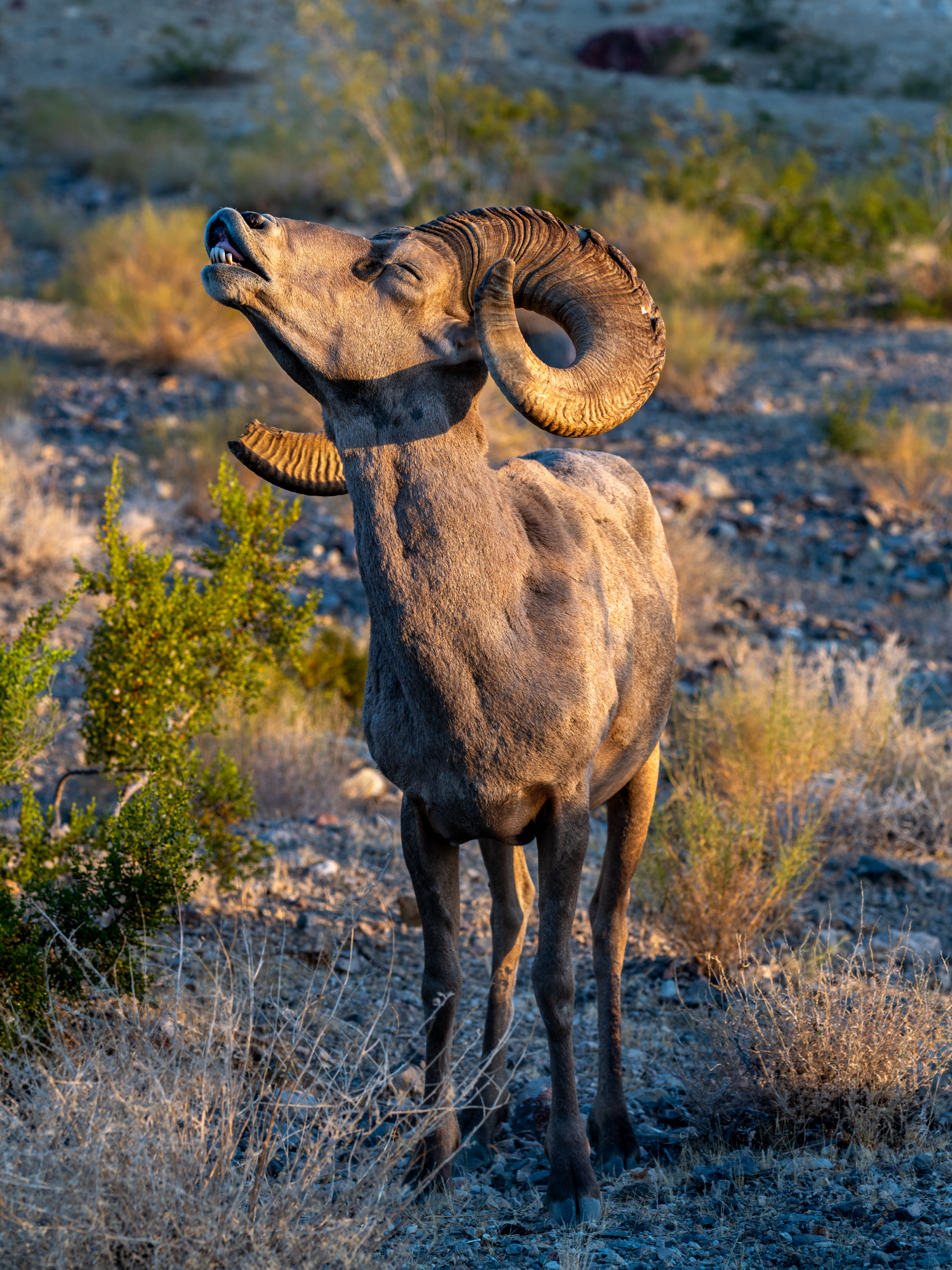
Desert Bighorn Sheep are the county’s signature animal. The San Rafael Swell holds Utah’s largest desert bighorn herd, a recovery success story whose population descends from reintroduction efforts begun in the 1970s after near-extirpation from the region. Bighorn favor steep, rocky cliff bands where their hooves grip surfaces a predator cannot follow. Look for them on the ledges above Buckhorn Wash, along the San Rafael Reef, on the cliffs above the Green River, and at water sources at dawn and dusk. A bighorn ram in profile against a sandstone wall is one of the great visual experiences the Swell can offer. Spring is lambing season (March–April); ewes and lambs concentrate near reliable water and may be visible from BLM roads if approached slowly and from a distance.
Mule Deer are Utah’s defining big-game species and the county’s most commonly seen large mammal. They migrate seasonally between high summer ranges on the Wasatch Plateau and Manti-La Sal National Forest and lower winter ranges on the desert benches and along the Reef. In June and July, watch for does with fawns in the high meadows of Joe’s Valley, Ferron Canyon, and Huntington Canyon. In October and November, large groups concentrate at the elevation transition near Castle Dale and Ferron, providing excellent dawn-and-dusk viewing from rural roads.
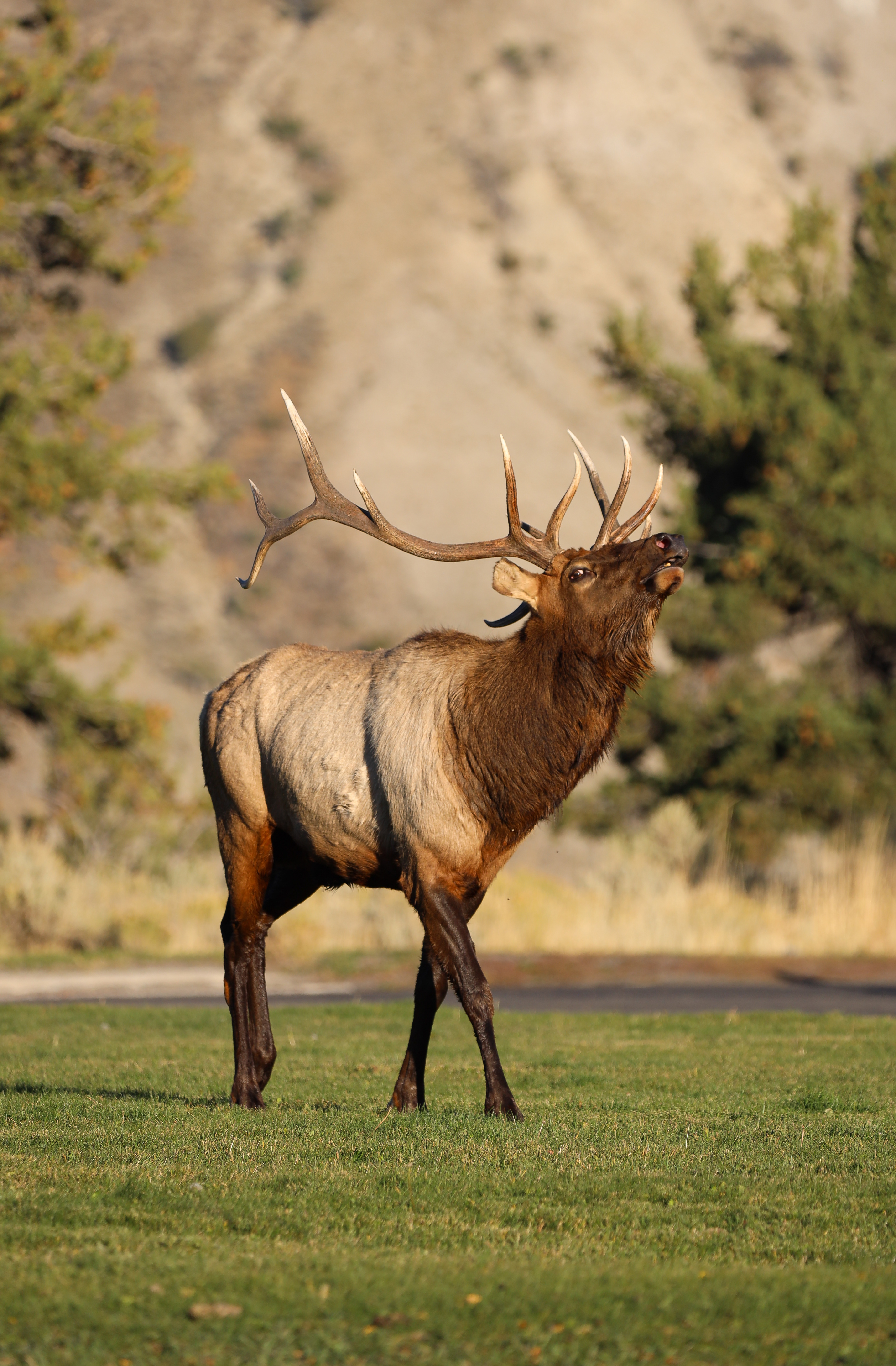
American Elk inhabit the high country in summer and lower elevations in winter. The peak experience is the fall rut, which builds through September. From any campsite at Joe’s Valley Reservoir or along the upper Huntington Canyon road, bulls bugling at dawn carry an unmistakable resonance — a high, breath-held cry that breaks into deep grunts. This is one of the audial signatures of the American West, and Emery County offers it as accessibly as any place in Utah.
Pronghorn Antelope are the county’s plains-dwellers. They favor open sagebrush flats where their extraordinary speed (capable of sustained 55-mph runs over distance — the second-fastest land mammal on Earth after the cheetah) is an asset against predators. The best viewing is along SR-10 between Ferron and the Wedge Overlook turnoff, and on the gravel approach roads to the Wedge itself. Pronghorn herds typically include a dominant buck attended by a harem of does; in late summer and fall, watch for fawns following at heel.
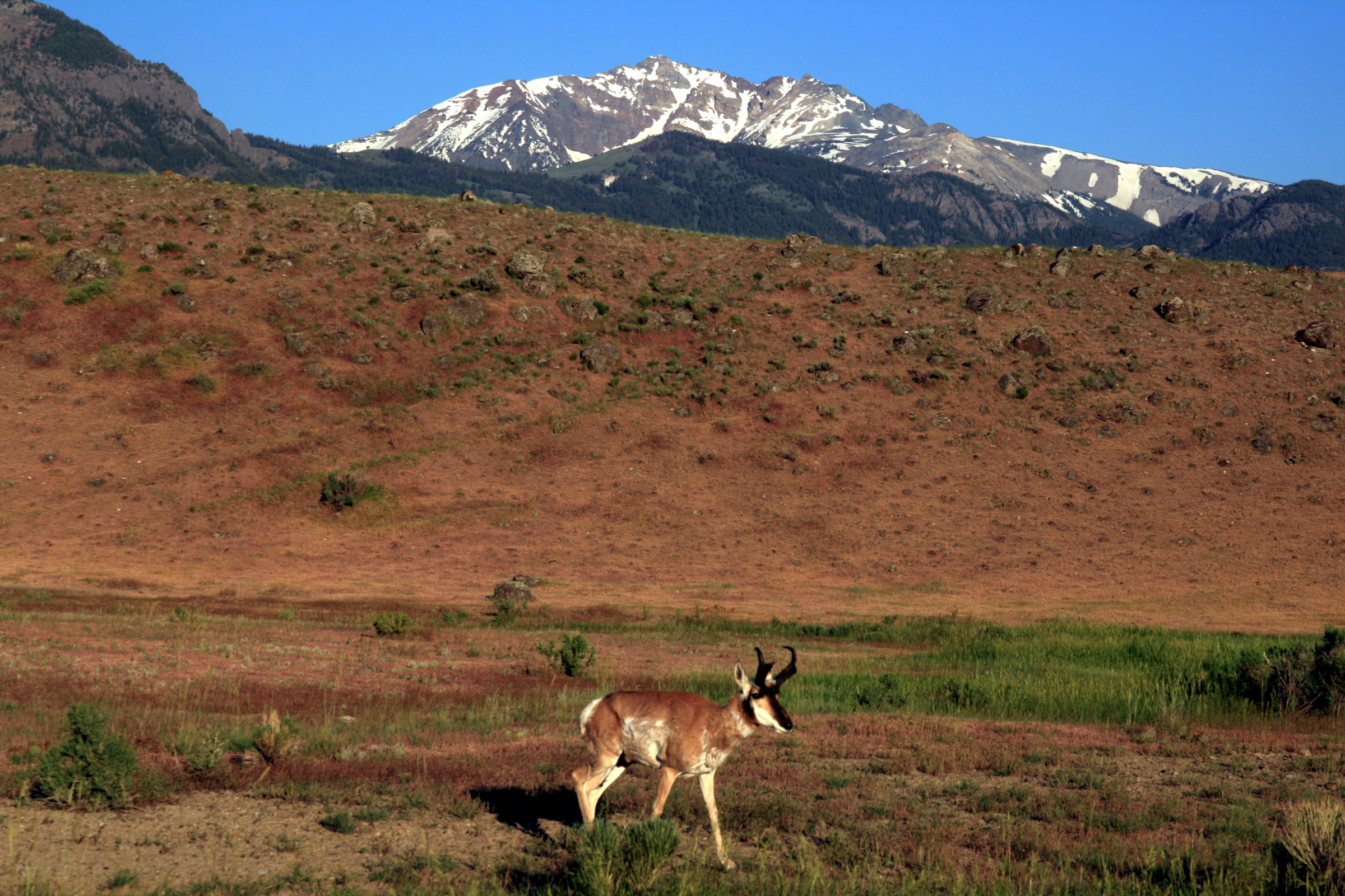
Did You Know? Pronghorn are not actually antelope — they are the sole living member of the family Antilocapridae, with no close relatives anywhere in the world. The species evolved alongside the now-extinct American cheetah, which is why pronghorn run faster than any North American predator alive today: their speed is calibrated to a hunter that no longer exists.
34.3 Predators and Smaller Mammals
The county supports a complete predator-prey community. Most predators are rarely seen by daylight visitors, but evidence — tracks, scat, calls at dusk — is everywhere if one looks.
Mountain Lion (Puma concolor) is the apex terrestrial predator of Emery County. Estimates suggest the Manti-La Sal and Swell support a healthy resident population, though individual cats range across vast territories (males may patrol 100+ square miles). A daylight sighting is exceptional; tracks in mud, snow, or red-rock dust are the wildlife watcher’s most likely encounter. Look for round prints roughly 3–4 inches across with no claw marks (cats walk with claws retracted, unlike dogs).
Black Bear occurs only at higher elevations on the Wasatch Plateau and Manti-La Sal high country, and even there is uncommon. Visitors are unlikely to encounter bears during typical day hikes; bear-aware food storage is nonetheless recommended for high-country overnight trips.
Bobcat and Coyote are common throughout the county. Coyotes are heard nightly from any campsite — a yipping chorus that builds at dusk and breaks into individual calls through the night. Bobcats are seen rarely but reliably along washes and around homesteads where rabbits concentrate.
Kit Fox and Red Fox both occur. Kit fox favors the open desert and is a Swell specialty; red fox is more common on the plateau and at the high-low transition.
Smaller Mammals. Jackrabbits and cottontails abound. The desert cottontail flushes from sagebrush along every dirt road. Beavers maintain dams on Huntington Creek and other perennial streams. Ringtails — small, nocturnal members of the raccoon family with bushy black-and-white tails — are present in the rocky canyons of the Swell but seldom seen except by spotlighting parties. Porcupines, badgers, and an array of mice, voles, and ground squirrels round out the cast.
34.4 Wild Horses and Burros of the Swell
Free-roaming herds of horses and burros are a distinct Swell experience. These animals are descended from domestic stock — some predating modern record-keeping, some released or escaped over the past 150 years — and are managed by the BLM under the 1971 Wild Free-Roaming Horses and Burros Act.
The county hosts portions of multiple Herd Management Areas (HMAs). The Sinbad HMA, south of I-70 in the southern Swell, is the most accessible to visitors traveling Buckhorn Wash and the Cottonwood Creek corridor. Horses appear most often near reliable water sources and during cooler hours.
Wild horses look like horses because they are horses — they are not a distinct wildlife species in the technical sense. But the experience of encountering a small band on open BLM range, the lead mare watching the visitor with the same wariness any wild animal would show, is part of the Swell’s enduring character.
34.5 Raptors and Birds of Prey
Emery County is, for raptor-watchers, exceptional. The combination of cliff-band nesting habitat, open hunting country, and reliable thermals over the Reef produces a raptor population that can be observed in flight on most clear days.
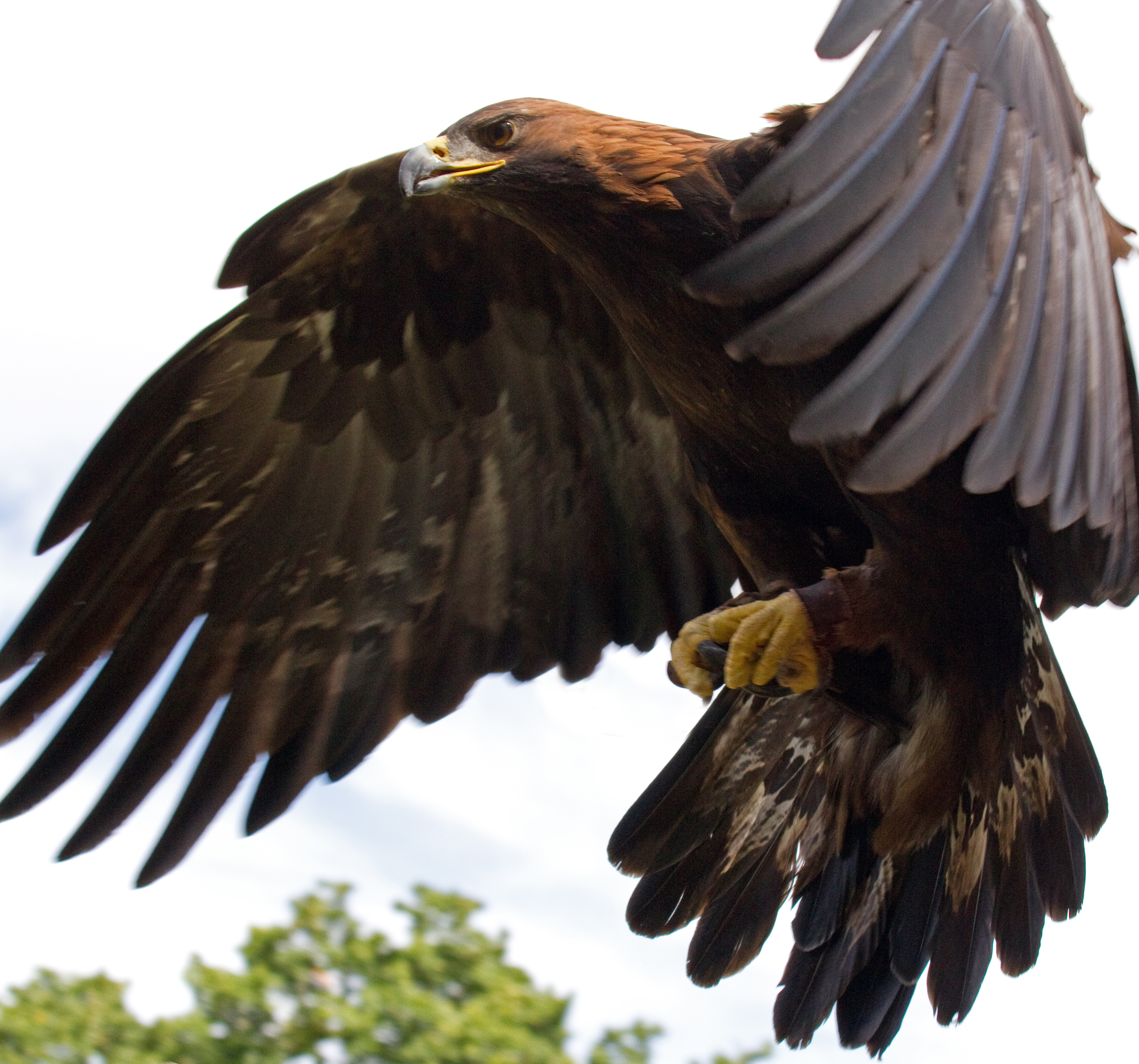
Golden Eagle (Aquila chrysaetos) is a year-round resident and one of the Swell’s true signature birds. Adults reach wingspans of 6 to 7 feet. Look for them soaring over the Reef and the Book Cliffs, often at considerable altitude. Golden eagles hunt live prey almost exclusively — rabbits and ground squirrels primarily, occasionally young deer or bighorn lambs. They nest on cliff bands and reuse the same eyrie for many years.
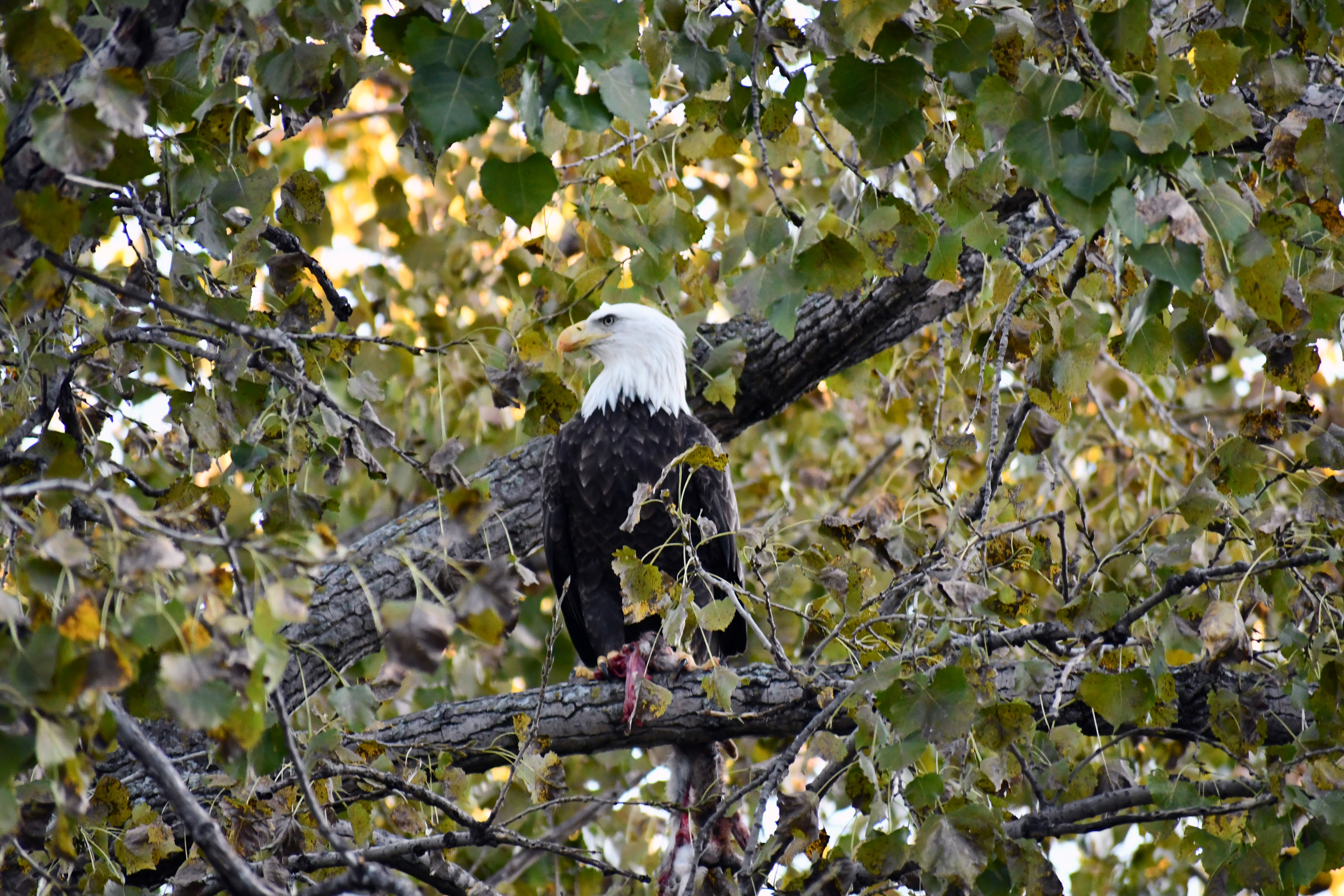
Bald Eagle (Haliaeetus leucocephalus) winters in Emery County along the Green River corridor. The species recovered from near-extinction in the lower 48 states (DDT-driven decline through the 1960s) and was removed from the federal endangered list in 2007, though it remains protected under the Bald and Golden Eagle Protection Act. Winter concentrations along the Green near Green River town occur from late November through February when other waters are frozen and the Green’s open channel concentrates fish.
Peregrine Falcon (Falco peregrinus) — once federally endangered and now recovered (delisted 1999) — nests on cliff bands of the Swell. Peregrines are the fastest animal on Earth in stooping dive (clocked above 240 mph), and witnessing a stoop on prey is among the most dramatic events the Swell can offer.
Prairie Falcon (Falco mexicanus) — similar in size to a peregrine but with a distinctive dark “armpit” pattern visible in flight — is the desert specialist of the falcon family and nests in the same cliff bands as peregrines.
Red-tailed Hawk is ubiquitous: roadside fenceposts, telephone poles, sagebrush flats. Each red-tail in the county is on station hunting ground squirrels and rabbits.
Owls. Great Horned Owls call from cottonwood groves along the rivers and from juniper-pinyon woodland; their territorial hooting is most active in late winter (the breeding season). Northern Saw-whet Owls inhabit the high-country spruce-fir on the Wasatch Plateau and are detected by their monotonous beeping call. Long-eared Owls roost in dense riparian thickets in the river corridors.
Did You Know? A peregrine falcon in stooping dive is the fastest creature on Earth — clocked above 240 mph. The bird folds its body into a teardrop shape and falls from altitude onto its prey, striking with talons that can knock a flying duck out of the sky at impact. The Swell’s cliff bands host nesting pairs of this once-endangered species, now recovered.
34.6 Songbirds, Waterfowl, and the Riparian Avifauna
The smaller and more numerous bird species pay back the attentive watcher most generously. Roughly 175 to 225 bird species occur in Emery County over the course of a year — a portion of southern Utah’s ~250-species total. [needs verification against current eBird county checklist]
Desert and Juniper-Pinyon Specialists. The Black-throated Sparrow is the desert songbird par excellence: white-and-black face mask, sage-grey body, conspicuous tail-flicking. It sings from atop low junipers and saltbush across the Swell. Pinyon Jay flocks — boisterous, social, and noisy — work juniper-pinyon woodland and are unmistakable in their nasal cries. Woodhouse’s Scrub-Jay (recently split from the Western Scrub-Jay species complex) is common along the same habitat margin.
Riparian Specialists. The Green River and the upper reaches of Huntington and Cottonwood creeks support a riparian bird community very different from the desert flats just outside the cottonwood canopy. Yellow Warbler, Bullock’s Oriole, Lazuli Bunting, Spotted Towhee, Yellow-breasted Chat, and Western Wood-Pewee all favor riparian corridors and breed there May through August. American Dippers — small, slate-grey songbirds that walk underwater along stream bottoms hunting aquatic insects — inhabit Huntington Creek and Cottonwood Creek year-round. A dipper bobbing on a creekside rock, then plunging in, is one of the more startling sights in Utah birding.
Waterfowl. Joe’s Valley Reservoir, Huntington North Reservoir, Millsite Reservoir, and Green River backwaters all host migratory and wintering waterfowl. Common Goldeneye, Mallard, Common Merganser, Bufflehead, Canvasback, Redhead, and Ring-necked Duck appear from October through April. Sandhill Cranes pass through in migration (March–April and September–October), and an alert listener may detect their distinctive bugling call high overhead.
Apps and Lists. The Merlin Bird ID app (Cornell Lab of Ornithology, free) is exceptionally good at sound identification — open the Sound ID feature in any habitat and Merlin will name the birds singing within earshot. eBird hotspots for Emery County include Joe’s Valley Reservoir, Green River SP, and Huntington North Reservoir.
34.7 Reptiles and Amphibians
The Swell’s reptile fauna is the highlight of any reptile-watcher’s visit to Emery County. Lizards in particular are visible, abundant, and often very approachable.
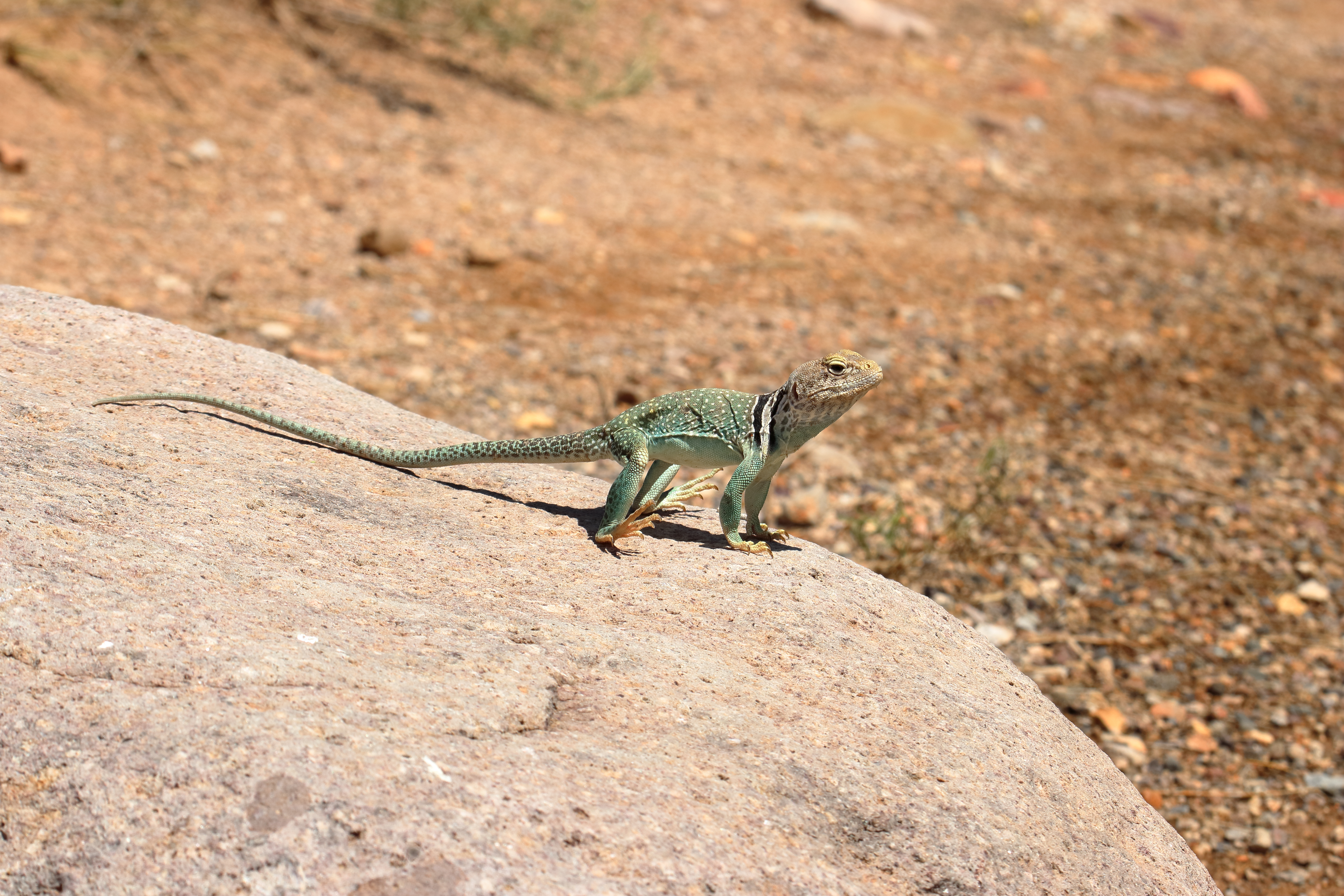
Lizards. Side-blotched Lizards (Uta stansburiana) are the most numerous reptile in the desert lowlands — small, fast, and ubiquitous. Eastern Collared Lizards (Crotaphytus collaris) are the most striking: emerald-green males with black neck collars, often sunning on prominent rocks during morning hours, and capable of running on their hind legs when chased. Desert Spiny Lizards inhabit rocky areas; Plateau Fence Lizards favor pinyon-juniper woodland; Sagebrush Lizards favor open sagebrush flats. Whiptails — long, slender, fast-moving lizards — flit across desert roads in midday heat.
Snakes. The Great Basin Rattlesnake (Crotalus oreganus lutosus) is the county’s only rattlesnake species. It is typically encountered in rocky areas during warm months, retreating to dens in cooler weather. Bites are extremely rare; rattlesnakes warn before striking and most encounters end without contact. Keep a distance of at least six feet, allow the snake to retreat, and do not attempt to handle or kill. Gopher Snakes (similar pattern to rattlesnakes but with a pointed tail and no rattle) are common and harmless. Striped Whipsnake and Western Terrestrial Garter Snake round out the regular fauna.
The Desert Tortoise — frequently asked about — does not occur in Emery County. Utah’s federally threatened Mojave Desert Tortoise population is restricted to the state’s southwestern corner (Washington County), several hundred miles from the Swell.
Amphibians. Northern Leopard Frog occupies riparian wetlands and reservoirs. Woodhouse’s Toad and Red-spotted Toad emerge after summer rains to breed in temporary pools — a sound a desert visitor may hear at night during the brief windows when the desert holds standing water. Tiger Salamanders inhabit some high-country reservoirs.
Activity Idea — Reptile Watching. Reptile watching has a specific etiquette. In the desert, reptiles are most active during morning hours in summer (avoid midday heat, which drives them into shade) and during midday in cooler months. Watch from a respectful distance; do not handle or capture. If you find a snake on the trail, stop, identify it, and either wait for it to retreat or detour around it. A field guide such as Stebbins’ Western Reptiles and Amphibians aids identification.
34.8 Fish and Aquatic Communities
For visitors who fish, and for those who simply watch from above, Emery County’s waters support a remarkable mix of native and introduced species. The native fauna includes some of the rarest fish in North America.
The Reservoirs. Joe’s Valley Reservoir (approximately 1,192 acres, 7,000 ft elevation, maximum depth 168 ft, average depth 44 ft) is a Utah DWR Blue Ribbon fishery, holding cutthroat trout, rainbow trout, tiger muskie, and trophy splake (a brook-lake-trout hybrid). Huntington North Reservoir holds wipers (a striped-bass/white-bass hybrid), rainbow trout, bluegill, largemouth bass, and channel catfish. Millsite Reservoir holds rainbow and brown trout.
The Streams. Huntington Creek above Huntington North Reservoir is a Blue Ribbon trout stream, with brown trout, rainbow trout, and a Bonneville cutthroat trout reintroduction program working to restore the native species. Cottonwood Creek and Ferron Creek hold similar mixes.
The Native Warm-Water Fish. The San Rafael River and the Green River support a native warm-water fish assemblage that includes the Three Species — flannelmouth sucker, bluehead sucker, and roundtail chub — declining native fishes whose conservation has been a focus of regional state and federal agencies for decades. The Green River through Emery County is designated Critical Habitat under the Endangered Species Act for four federally endangered Colorado River endemic fishes: humpback chub (Gila cypha), Colorado pikeminnow (Ptychocheilus lucius) — the largest minnow in North America, once reaching six feet, now severely diminished — bonytail chub (Gila elegans), and razorback sucker (Xyrauchen texanus). These species are difficult for visitors to observe, but their presence makes the Green River corridor one of the most biologically significant water bodies in the Colorado River Basin.
Licensing. All take requires a Utah fishing license (resident annual $34; nonresident options available). Observation requires no license.
34.9 Deep-Time Wildlife — Cleveland-Lloyd Dinosaur Quarry
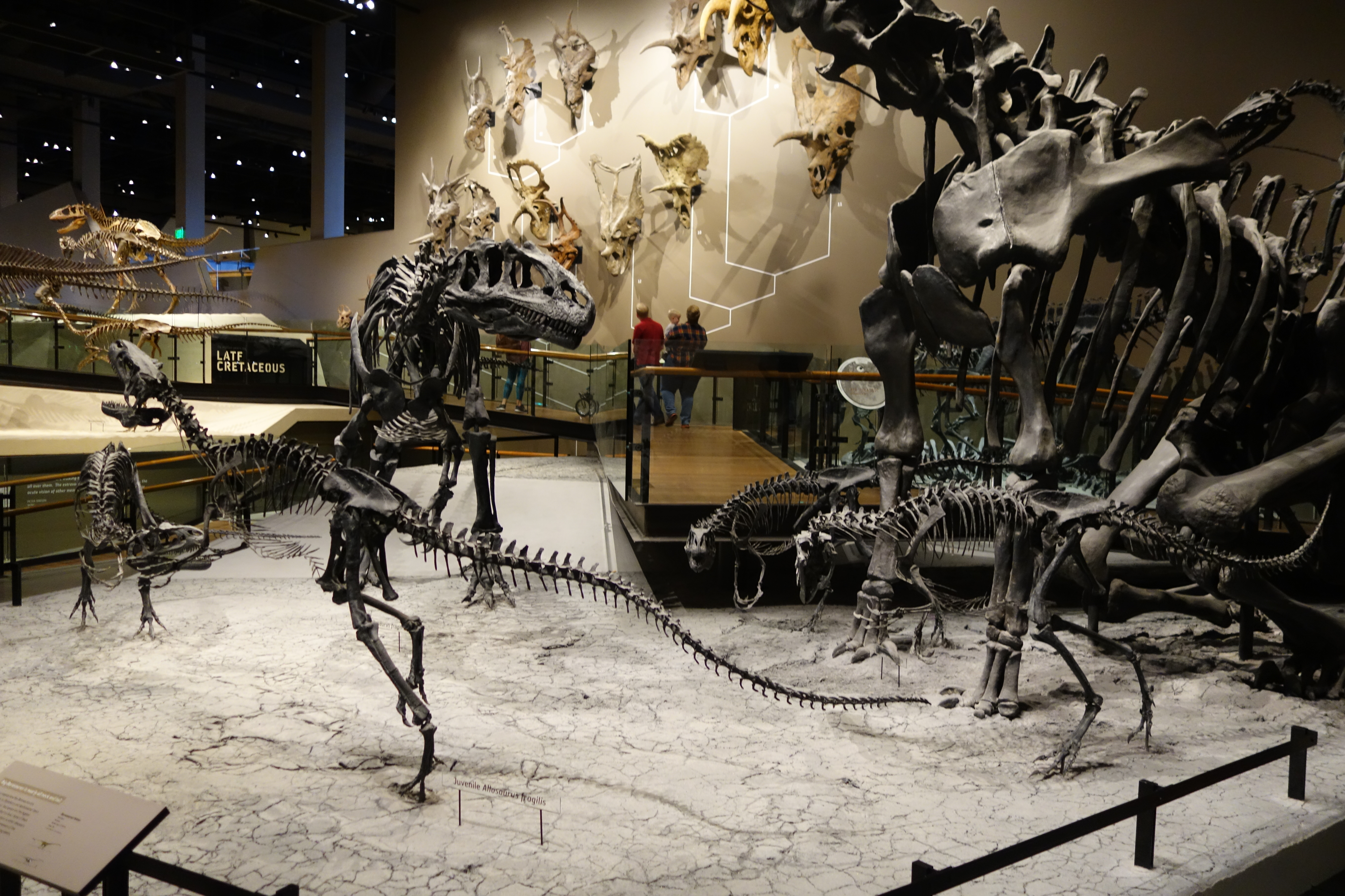
A different kind of wildlife watching is available at the Cleveland-Lloyd Dinosaur Quarry, the centerpiece of the Jurassic National Monument designated by the same 2019 Dingell Act that created the San Rafael Swell Recreation Area. The quarry, on BLM-managed land about 33 miles from Price and 21 miles from Huntington (the last 11 miles on a graded dirt road), contains the densest concentration of Jurassic dinosaur fossils ever found anywhere on Earth.
To date, more than 12,000 fossil bones (some sources count well over 15,000) have been excavated from the quarry, representing at least 74 individual dinosaurs — some recent estimates put the count near 75 — from approximately 10 to 12 species. The site is notable for its unusually high proportion of carnivorous animals: more than three-quarters of the identified individual dinosaurs are theropod predators, primarily Allosaurus fragilis, with at least 44 individuals confirmed and some published counts approaching or exceeding 46. Theories about why so many predators accumulated in one place (a Jurassic predator trap? a poisoned watering hole? a mass-mortality event?) remain unresolved, and the site continues to be excavated by the University of Utah and the Natural History Museum of Utah.
For the visitor, the on-site visitor center houses interactive displays, bone-bed maps, replica skulls, and an Allosaurus skeleton mount. Walking the quarry boardwalk and reading the layered geology of the Morrison Formation — the rock unit that yields nearly all of the great dinosaur fossils of the American West — connects modern wildlife watching to the deep evolutionary past. Allosaurus hunting Camarasaurus in Emery County 150 million years ago is the same drama, in different actors, as Cougar hunting Mule Deer in the Wasatch Plateau today.
34.10 Where to Watch — A Hotspot Field Guide
| Location | Habitat | Primary Targets | Access |
|---|---|---|---|
| The Wedge Overlook | Open sagebrush + canyon rim | Pronghorn, raptors, mule deer | 13 mi gravel from SR-10 N of Castle Dale |
| Joe’s Valley Reservoir & Canyon | Spruce-fir / reservoir | Elk (fall rut), waterfowl, songbirds, dippers | SR-29 W from Orangeville |
| Buckhorn Wash | Riparian canyon | Bighorn sheep, riparian birds, bats | Castle Dale → Buckhorn Wash Backway |
| San Rafael Swinging Bridge area | Riparian / cliff | Bighorn, bats, dipper, lizards | Buckhorn Wash, end of dirt road |
| Ferron Canyon / Ferron Reservoir | Mixed conifer / reservoir | Elk, deer, native cutthroat | SR-10 → Ferron → Ferron Canyon Rd |
| Huntington Canyon (SR-31) | Mixed conifer / creek | Elk, deer, dipper | SR-31 W from Huntington |
| Cleveland-Lloyd Dinosaur Quarry | ”Deep-time” wildlife | Jurassic megafauna fossils | 33 mi from Price; last 11 mi gravel |
| Green River State Park | Riparian / open water | Bald eagle (winter), waterfowl, songbirds | I-70 exit at Green River |
| Sinbad Country (S of I-70) | Open desert | Wild horses | Various dirt access roads |
| Manti-La Sal NF (Skyline Drive) | Subalpine forest | Bear, mountain goat (rare), high-country birds | FR-022 — seasonal access |
34.11 When to Watch — A Seasonal Calendar
March–May (Spring). The county’s most productive watching season for diversity. Bighorn lambing in the Swell (March–April). Spring bird migration peaks late April through mid-May; warblers, vireos, tanagers, and shorebirds move through. Reptiles emerge from brumation in late March in the desert. Wildflowers (which support pollinators worth watching) peak in May at lower elevations.
June–August (Summer). Lower-elevation activity drops in midday heat; high country comes alive. Fawns appear on the plateau. Songbirds in full breeding season. Reptiles active dawn and dusk only. Cleveland-Lloyd Quarry visitor center is open daily June through August.
September–November (Fall). The county’s signature wildlife season. Elk rut peaks mid-September on the plateau; bugling carries for miles in still morning air. Bald eagles and waterfowl begin arriving in October. Deer migration brings large herds to lower elevations in November. Raptor migration along the Reef and Book Cliffs runs September through early November. Cool temperatures make midday reptile activity reliable again.
December–February (Winter). Bald eagles concentrate along the Green River, easily viewed from Green River State Park. Mule deer and elk concentrate on lower-elevation winter ranges, often visible from highways. Bighorn rut runs November through January. The high country is largely closed by snow; SR-29 to Joe’s Valley may be drifted shut. Bird species count drops sharply, but raptors and waterfowl remain.
34.12 Watching Ethics, Equipment, and Agencies
Watching Ethics.
- Distance. Use binoculars or a spotting scope rather than approaching. Minimum recommended distances: 50 yards for small mammals; 100 yards for large mammals; 200 yards for predators and nesting raptors.
- No feeding. Feeding habituates animals to humans and frequently leads to their euthanasia as “problem” animals. Pack out all food scraps.
- Stay on roads and trails. Vehicle and foot disturbance flushes nesting birds and harasses hooved animals. Cross-country travel is also illegal in many BLM and NPS units.
- Don’t publish locations of sensitive sites. Raptor nests, bighorn lambing areas, and Mexican spotted owl territories are vulnerable to disturbance. Report sightings to BLM or DWR rather than posting GPS coordinates publicly.
- Photograph respectfully. A photograph that requires you to flush a bird from its nest, or push a herd of deer off a hillside, is not worth taking.
Equipment.
- Binoculars: 8×42 or 10×42 are the standard “all-purpose” configurations. For the Swell’s openness, 10× rewards the effort.
- Spotting scope: 60–85mm objective with 20–60× zoom, useful for cliff-band raptor work and distant pronghorn.
- Field guides: Sibley’s Field Guide to Birds of Western North America; Stebbins’ Peterson Field Guide to Western Reptiles and Amphibians; a mammal track guide for indirect observation.
- Apps: Merlin Bird ID (free, Cornell Lab) — sound and photo bird identification; iNaturalist (free) — universal organism identification and citizen-science recording; eBird (free) — bird checklist submission and hotspot information.
Agencies and Resources.
- Utah Division of Wildlife Resources (DWR): wildlife.utah.gov — fishing/hunting licenses, Hunt Planner, Wildlife Management Area maps, regulations.
- BLM Price Field Office: 125 South 600 West, Price, UT 84501 — 435-636-3600.
- BLM Green River District: 170 South 500 East, Green River, UT 84525 — 435-564-3170.
- U.S. Forest Service — Manti-La Sal National Forest: Ferron/Price Ranger District — 435-384-2372.
- iNaturalist Emery County: inaturalist.org/places/emery-county — hundreds of geolocated observation records.
- eBird: ebird.org — Emery County bar charts and hotspots.
Sources
- Bureau of Land Management. “San Rafael Swell Recreation Area.” blm.gov/visit/san-rafael-swell-recreation-area.
- Bureau of Land Management. “Jurassic National Monument / Cleveland-Lloyd Dinosaur Quarry.” blm.gov.
- Utah Division of Wildlife Resources. “Wildlife Viewing.” wildlife.utah.gov/viewing.
- Utah Division of Wildlife Resources. “Wildlife/Waterfowl Management Areas.” wildlife.utah.gov/wmas.html.
- Utah Division of Wildlife Resources. “Hunt Planner.” hunt.utah.gov.
- Utah Division of Wildlife Resources. “Fish Utah — Joe’s Valley Reservoir.” dwrapps.utah.gov/fishing.
- Visit Utah. “Cleveland-Lloyd Dinosaur Quarry.” visitutah.com.
- Visit Emery County. “Joe’s Valley Reservoir.” visitemerycounty.com.
- Junesucker.com. “Joe’s Valley Reservoir” and “Huntington North Reservoir.”
- A-Z Animals. “Wildlife in Utah.”
- Mia McPherson’s On the Wing Photography. “San Rafael Swell and The Wedge.”
- iNaturalist. “Emery County.” inaturalist.org/places/emery-county.
- Cornell Lab of Ornithology. “eBird Emery County, Utah Hotspots.”
- Reptiles of Utah. reptilesofutah.com — Utah lizard and snake species accounts.
- Sibley, David Allen. Field Guide to Birds of Western North America. Knopf, current ed.
- Stebbins, Robert C. Peterson Field Guide to Western Reptiles and Amphibians. Houghton Mifflin Harcourt, current ed.
- U.S. Fish & Wildlife Service. “Colorado River Endangered Fish Recovery Program.”
- Wikipedia. “Jurassic National Monument” and “Pronghorn.”
- John D. Dingell, Jr. Conservation, Management, and Recreation Act, Public Law 116-9 (March 12, 2019).
Proposed Maps and Figures
- Map — Emery County Habitat Zones. Three-zone map showing Wasatch Plateau / Manti-La Sal high country, San Rafael Swell desert, and Green River riparian corridor with elevation gradient overlay. Scale 1:300,000.
- Map — Wildlife Hotspots. Marker map of the 10 locations from Table 34-A with road access and habitat type indicated. Scale 1:200,000.
- Photo — Desert Bighorn Sheep on Reef. Profile against sandstone wall; ideally a ram or ewe-with-lamb.
- Photo — Elk Bull in Rut. Bugling bull, autumn lighting, plateau habitat.
- Photo — Pronghorn on the Wedge approach. Open sagebrush flats.
- Photo — Golden Eagle in flight. Soaring against canyon backdrop.
- Photo — Bald Eagle along Green River. Winter perched shot in cottonwood.
- Photo — Eastern Collared Lizard. Emerald male with neck collar; characteristic posture on prominent rock.
- Photo — Cleveland-Lloyd Quarry Bone Bed. Visitor center display of the fossil-rich layer.
- Infographic — Recommended Watching Distances. Diagram showing 50/100/200-yard guideline with figure-and-binoculars for scale.
- Infographic — Seasonal Wildlife Calendar. Month-by-month visual of major species activity (rut, migration, lambing/calving).
Proposed Tables
- Table 34-A — Wildlife Hotspots. Already drafted in §34.10.
- Table 34-B — Seasonal Calendar. Already drafted in §34.11.
- Table 34-C — Watching Distances and Ethics. §34.12 summary as table.
- Table 34-D — Endangered and Threatened Species in Emery County. ESA-listed species with habitat, status, and viewing notes.
- Table 34-E — Reservoir Fisheries Summary. Joe’s Valley, Huntington North, Millsite — species, regulations, access.
Engagement Features
Did You Know?
- Pronghorn evolved for a predator that no longer exists. Their sustained 55-mph speed is calibrated against the American cheetah, which went extinct roughly 12,000 years ago at the end of the Pleistocene. The pronghorn is, in evolutionary terms, running from a ghost.
- A peregrine falcon in stooping dive is the fastest creature on Earth — clocked above 240 mph. The bird folds its body into a teardrop shape and falls from altitude. The Swell’s cliff bands host nesting pairs of this once-endangered species.
- The Cleveland-Lloyd Dinosaur Quarry contains the densest concentration of Jurassic dinosaur fossils ever found on Earth — more than 12,000 bones, with predator-prey ratios that flip the modern ecological pyramid upside down. Why so many predators died here, in one place, remains one of paleontology’s enduring mysteries.
- The Colorado pikeminnow once reached six feet in length and was the apex predator of the prehistoric Colorado River. The few remaining individuals — still spawning in the Green River through Emery County — are a living connection to a river that once flowed without dams.
- Wild horses on the Sinbad Range are not native to North America in the modern sense — the species went extinct on the continent around 12,000 years ago, then was reintroduced by Spanish colonists in the 16th century. The Swell’s horses descend from this re-introduction.
Family Activity — Habitat Zone Day Trip
Plan a one-day trip that traverses all three of Emery County’s biological worlds in a single afternoon. Start at the Wedge Overlook in the morning (pronghorn, golden eagles, the canyon rim view), drive down to Buckhorn Wash and the Swinging Bridge by midday (bighorn ledges, riparian dippers, swallows over the river), and end at Green River State Park near sunset (bald eagle in winter, waterfowl, cottonwood-corridor songbirds). Bring binoculars, a field guide, and a paper map. Each family member keeps a personal species list — at the end of the day, compare totals.
Youth Challenge — Wildlife Bingo
Create a 5×5 bingo card with these target species for the trip. The first person to spot one from each row (or all 25) earns a prize. Suggested cells:
| Mule deer | Golden eagle | Side-blotched lizard | Magpie | Coyote print |
| Bighorn (any age) | Red-tailed hawk | Pronghorn | Raven | Tracks (any) |
| Elk (heard counts) | American Dipper | Collared lizard | Western Bluebird | Beaver dam |
| Rabbit (any) | Turkey vulture | Whiptail | Songbird (any small) | Owl pellet |
| Squirrel (any) | Eagle (any species) | Snake (any species) | Scat (identify) | Burrow (active) |
The point is not the bingo per se — it’s that children learn to look closely at small things (tracks, pellets, scat, dens) instead of holding out for “the big animals.” A coyote print in dried mud teaches as much about who lives in a place as a coyote does.
Field Trip — A Wildlife Watcher’s Weekend
Saturday Morning — Joe’s Valley Reservoir & Canyon. Drive SR-29 west from Orangeville to Joe’s Valley Reservoir (about 14 mi). Listen at dawn (best early September through October) for bull elk bugling in Joe’s Valley Canyon above the reservoir. Walk the lakeshore for waterfowl. Continue up Skyline Drive (FR-022; check seasonal closure) for high-country birds.
Saturday Afternoon — Buckhorn Wash & Wedge. Return to Castle Dale, then take the Buckhorn Wash Backway north. Stop at the Wedge Overlook (13-mi gravel access; sturdy passenger car OK in dry conditions). Scan for pronghorn on the approach flats and golden eagles soaring the canyon thermals. Descend into Buckhorn Wash to the Swinging Bridge by late afternoon — bighorn ledges visible above the road, dippers on the river-side rocks.
Sunday Morning — Cleveland-Lloyd Dinosaur Quarry. Drive to the quarry (33 mi from Price; last 11 mi graded gravel). Open seasonally; check BLM hours. Walk the boardwalk; read the bone-bed display; visit the Allosaurus mount in the visitor center.
Sunday Afternoon — Green River State Park. Continue east to Green River (about an hour from Cleveland-Lloyd). In winter, scan the cottonwoods for bald eagles. Year-round, scan the river surface for waterfowl, the banks for kingfishers, and the riparian thicket for songbirds.
Equipment list: Binoculars (8×42 or 10×42), field guide (Sibley or Audubon), notebook, Merlin Bird ID app, full tank of gas, water (a gallon per person per day, even on a half-day trip), paper county map (cell service is unreliable in the Swell).
Photo Assignment — The Bighorn Profile
The signature wildlife photograph of Emery County is a desert bighorn ram or ewe in profile against a sandstone wall. The combination of the animal’s classic stance (head raised, horn-curl visible), the geological color of the Wingate, and the dry desert light produces an image that is recognizably from this place and nowhere else.
To attempt this photo:
- When: Early morning or late afternoon golden hour. Bighorn descend from cliff bands to water sources at these times.
- Where: Cliffs above Buckhorn Wash, along the Reef near the San Rafael River campground, on the ledges visible from the Swinging Bridge.
- How: Use a 400 mm or longer lens. Bighorn tolerate vehicles better than people on foot — photograph from a parked vehicle whenever possible. Move quietly if you must approach on foot; if the animal raises its head and stops chewing, you are too close.
- Ethics: Never flush an animal for a photograph. If the sheep walks away, the photograph was not meant to happen that day. Try again at first light tomorrow.
Submit the best image, with date and approximate GPS waypoint, to the encyclopedia’s digital companion under “Reader Field Reports.”