Part 2 · Peoples
Navajo & Puebloan Interactions
Athabaskan migration, Pueblo Revolt diaspora, trade networks, pastoral revolution, and the deep cultural exchanges between Navajo, Puebloan, and Ute peoples across the Colorado Plateau.
Ch11 — Navajo & Puebloan Interactions
The story of Emery County’s indigenous past does not end with the Fremont or the Numic-speaking peoples who succeeded them. To the south and east, two of the most influential cultures in the American Southwest — the Navajo (Diné) and the Puebloan peoples — shaped trade networks, migration corridors, and cultural exchanges that rippled northward into the canyons and plateaus of east-central Utah. While neither group established permanent settlements within Emery County’s present boundaries in the way the Fremont or Ute did, their presence on the broader Colorado Plateau profoundly influenced the region’s human geography. Understanding these interactions is essential to grasping the full cultural landscape in which Emery County sits.
11.1 Athabaskan Migration & Diné Origin Narratives
The Navajo, or Diné (“the People”), belong to the Athabaskan language family, a linguistic group whose closest relatives live thousands of miles to the north in interior Alaska and western Canada. Most archaeologists believe the Na-Dene peoples crossed the Bering land bridge during the last Ice Age and gradually migrated southward over millennia, with Athabaskan-speaking groups eventually splitting into northern and southern branches. The southern Athabaskans — ancestors of the Navajo and Apache — arrived in the American Southwest sometime between 1300 and 1500 CE, though the exact timing remains debated (Haskell, 1987; Young, 1978). The earliest known Navajo archaeological site in Utah is a hogan at White Canyon in San Juan County, dated by tree-ring analysis to approximately 1620. Spanish maps from the 1660s describe Navajo territory as extending well north of the San Juan River, and early treaties reference Navajo presence as far north as present-day Green River — placing them at the very doorstep of Emery County. Some researchers have proposed an alternative migration route through modern Utah, west of the Rocky Mountains, which would have brought Athabaskan migrants through or near the Colorado Plateau’s canyon corridors long before European contact (History to Go, Chapter 7).
Diné oral tradition tells a different story of origins. The Navajo emergence narrative describes the People passing through a series of underworlds before emerging into the Glittering World (Ni’hodilhil) between the four sacred mountains. This spiritual geography anchors Navajo identity to specific landscapes in the Four Corners region, with Bears Ears and the surrounding canyon country holding particular significance as places of refuge and ceremony.
11.2 Early Exchange with Pueblo Peoples
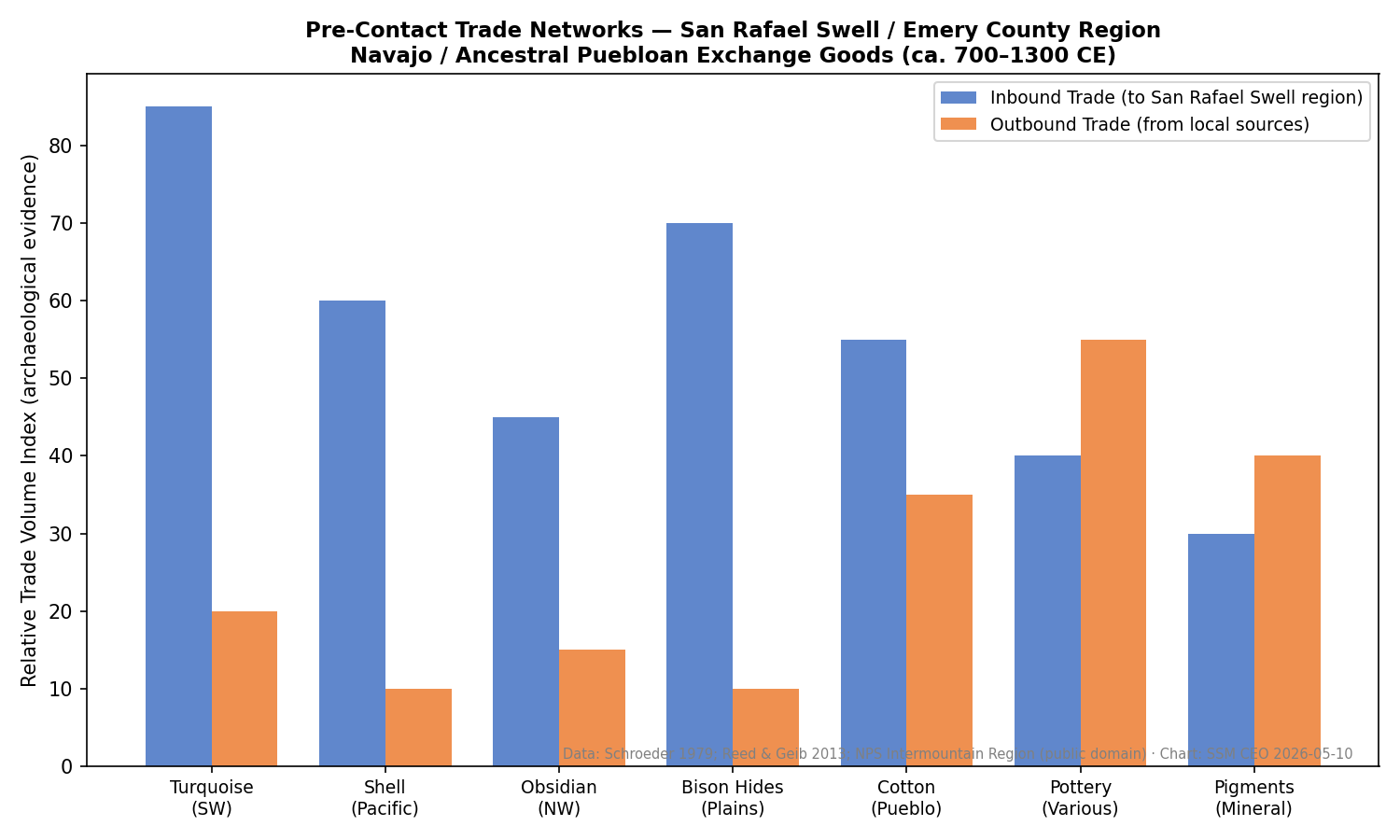
Long before Europeans arrived in the Southwest, Athabaskan newcomers and the settled Pueblo communities of the Rio Grande, Zuni, and Hopi established complex relationships of trade and cultural borrowing. Mid-sixteenth-century Spanish records document that Pueblo peoples exchanged maize and woven cotton goods for bison meat, hides, and lithic material brought by Athabaskan groups who traveled to the pueblos or lived nearby (Navajo Wikipedia; NM Historic Sites curriculum).
These exchanges were not merely economic. Over generations, Navajo culture absorbed significant Puebloan influences: agricultural techniques for growing corn, beans, and squash in arid soils; weaving traditions that would eventually produce the iconic Navajo textile art; and elements of ceremonial practice, including sand painting and certain healing rituals. The cultural transfer ran both directions — Pueblo communities adopted certain Athabaskan hunting practices and defensive strategies. The broader trade networks of the Colorado Plateau provided the context for these interactions. From roughly 900 to 1150 CE, the Chaco great-house society facilitated exchange routes stretching from northern Arizona into southwestern Colorado and southern Utah. Goods such as turquoise, shell, obsidian, macaw feathers, and ceramics moved along these corridors, and the networks persisted in modified form long after Chaco’s decline. While Emery County lies at the northern periphery of these systems, the San Rafael Swell and the Green River corridor served as natural pathways connecting the Puebloan heartland to the Fremont territories — a geographic reality that facilitated intermittent contact across cultural boundaries.
11.3 The Pueblo Revolt of 1680 & Refuge Diaspora
On August 10, 1680, the Pueblo peoples of New Mexico launched a coordinated uprising against Spanish colonial rule that remains one of the most significant acts of Indigenous resistance in North American history. Led by the Tewa religious leader Popé, warriors from dozens of pueblos killed approximately 400 colonists (including 21 Franciscan friars) and drove the remaining 2,000 settlers south to El Paso del Norte. For twelve years, the Pueblo peoples governed themselves free of Spanish control (Indian Pueblo Cultural Center; Britannica).
The revolt’s aftermath sent ripples far beyond New Mexico. Refugee communities scattered in multiple directions: the people of Galisteo moved first to Santa Fe, then to the Española Valley, and eventually to Hopi, where they established Hano (Tewa Village) on First Mesa around 1700. Other groups sought shelter among the Navajo, who lived in the uplands west and north of the Rio Grande pueblos. This influx of Pueblo refugees into Navajo communities accelerated the cultural exchange that had been building for generations — Pueblo women brought weaving skills, agricultural knowledge, and ceremonial traditions that became deeply integrated into Navajo life.
Whether any Pueblo refugees moved as far north as the Emery County region remains an open question. No direct archaeological evidence has been found for post-1680 Pueblo settlements in east-central Utah. However, the canyon country between the San Juan and Green rivers offered the kind of defensible, well-watered terrain that refugee groups sought, and the possibility of small, transient camps cannot be ruled out. Recent discoveries at Range Creek Canyon — where square, coursed-stone walls resembling Puebloan above-ground architecture have been found alongside typical Fremont features — hint at Puebloan cultural influence reaching further north than previously assumed, though these sites predate the Revolt by centuries (NHMU, Range Creek).
Traditional Navajo sandpainting is never meant to last. Created during healing ceremonies by trained ceremonial practitioners, each painting is ritually destroyed at the ceremony's end — the sand swept away so the sacred images cannot be misused. The permanent sandpaintings sold in galleries and trading posts since the 1930s are intentionally altered versions: practitioners made protective modifications (reversing key elements or omitting critical details) so the commercial form could be shared without compromising ceremonial integrity. What you see in a gift shop and what takes place in a healing ceremony are deliberately, carefully different.
— Navajo cultural practice
11.4 Pre-Colonial Trade Highways
The Colorado Plateau was never an empty wilderness. For thousands of years, trade routes threaded through its canyons and across its mesas, linking communities separated by hundreds of miles. The most significant of these networks centered on the Chaco great houses (900–1150 CE), which served as redistribution hubs for turquoise from the Cerrillos mines, shell from the Gulf of California, obsidian from volcanic sources, and ceramics from dozens of production centers. Goods moved hand-to-hand along trails that followed natural corridors — river valleys, canyon mouths, and passes through the escarpments.
By the time the Navajo arrived in the region, these routes were well established. The Ute peoples, who controlled much of eastern Utah, participated in annual trade fairs or rescates held at Rio Grande pueblos including Taos, Santa Clara, and Pecos. At these gatherings, Utes exchanged hides, dried meat, and slaves for woven blankets, pottery, and corn. The Navajo also attended these fairs, trading alongside and sometimes in competition with Ute bands (History to Go, Chapter 5; Ute Wikipedia).
The route that would later become the Old Spanish Trail — connecting Santa Fe to Los Angeles through central Utah — formalized a path that Indigenous traders had used for centuries. This trail passed through the vicinity of present-day Green River and the northern San Rafael region, placing Emery County along one of the most important commercial corridors in the pre-American West. While the trail is most associated with the Spanish colonial and Mexican periods, its Indigenous precursors carried Navajo, Ute, and Pueblo goods through this landscape long before European pack trains.

Buckhorn Draw Pictograph Panel
One of Utah's largest and most vivid Fremont pictograph sites — a sandstone gallery shaped by millennia of passing cultures.
On the ground
The Buckhorn Panel features dozens of broad trapezoidal Fremont anthropomorphs, bighorn sheep, and abstract symbols painted in red ochre on a sandstone overhang. Look for style differences that suggest multiple periods of painting. The adjacent canyon was almost certainly part of the trade corridor described in this section; people moving goods between the Green River and the Puebloan heartland to the south would have passed this way. BLM asks all visitors to stay behind the protective fence and not touch the painted surface — even skin oils accelerate fading.
See also: Chapter 9 (Fremont Culture) · Chapter 10 (Ute Heritage)
11.5 Shared Rock-Art Symbolism
The rock faces of Emery County and the surrounding region preserve a palimpsest of cultural expression spanning three millennia. In the San Rafael Swell alone, rock art panels display styles from the Archaic period (Barrier Canyon Style), the Fremont era, the Ancestral Puebloan tradition, and later Ute and Navajo periods — sometimes layered on the same panel, creating a visual record of successive peoples engaging with the same sacred landscapes (climb-utah.com; USU Prehistoric Museum). Barrier Canyon Style pictographs — elongated, haunting anthropomorphic figures often lacking arms or legs — represent the oldest artistic tradition in the region, likely predating all the cultures discussed in this chapter. Fremont petroglyphs, by contrast, are richly detailed: large trapezoidal figures adorned with necklaces, earrings, shields, and elaborate headdresses, accompanied by spirals, zigzags, bighorn sheep, and hunting scenes. Ancestral Puebloan imagery, found primarily south and east of Emery County but occasionally overlapping with Fremont territory, includes the distinctive flute-playing Kokopelli figure, bighorn sheep, and geometric patterns that reflect the Puebloan cosmological worldview.
Navajo rock art in the broader region tends to appear as lighter, more recent carvings and paintings — horses, riders, and ceremonial figures that contrast with the heavier desert varnish of older panels. While major Navajo rock art concentrations lie south of Emery County in the Navajo reservation and Bears Ears areas, their presence on some San Rafael panels speaks to at least intermittent Navajo use of the region in the historical period. Identifying and interpreting these later additions requires care, as Navajo traditional practice treats certain rock art sites as sacred places where images should not be casually disturbed or documented.
Four-Style Rock-Art Detective: Emery County Edition
- □ A Barrier Canyon Style pictograph — look for tall, elongated figures with no arms or legs, often painted in dark red. Black Dragon Canyon (Hwy 24 corridor) is one of the finest examples in the world.
- □ A Fremont-style petroglyph — search for broad trapezoidal figures with headdresses, necklaces, or earrings, pecked (not painted) into darkly varnished sandstone. Buckhorn Draw is the best starting point.
- □ A bighorn sheep image — this subject appears across multiple traditions; examine the artistic style to guess which cultural period it most likely belongs to.
- □ A panel showing at least two distinct styles or patination levels — evidence that multiple groups used the same rock face across centuries. Darker varnish generally means older; lighter images are usually more recent.
Share your finds! #EmeryEncyclopedia
Reading Time in Stone: Photograph a Multi-Period Panel
- Your subject
- A rock art panel where two or more cultural traditions are visible in the same frame — different styles, different patination depth, or one image clearly overlapping another
- Where to find it
- What to look for
- The story you're telling
- Each painted layer represents people who found meaning in this exact spot — who stopped, looked at what earlier visitors had left, and decided to add their own voice. Your photograph captures that ongoing conversation across millennia.
Share your photo with #EmeryEncyclopedia
11.6 Alliances & Conflicts
The relationships among Navajo, Puebloan, and Ute peoples were never static. Alliances formed, fractured, and reformed as circumstances changed — driven by competition for resources, the pressures of European colonialism, and the devastating introduction of the slave trade.
In the early 1700s, Navajos began moving into the San Juan River drainage in search of pasture for their growing herds. This expansion brought them into direct contact — and frequent conflict — with Ute bands who considered the region part of their territory. From the 1720s through the 1740s, Ute raiding parties struck Navajo camps with devastating effect, forcing many Diné families to retreat southward. By 1750, whatever alliance had existed between Utes and Navajos had collapsed (History to Go, Chapter 5).
The geopolitical landscape shifted repeatedly. At various points, Navajos allied with the Spanish and Apache against the Ute-Comanche partnership. Yet Spanish records also document periods when Navajos and Utes cooperated — stealing horses together, conducting joint slave raids, and sharing camps in the La Plata and Sleeping Ute Mountains. These shifting alliances reflected the pragmatic survival strategies of peoples caught between expanding European power and fierce intertribal competition. The slave trade cast a long shadow over all these relationships. The Spanish colonial system created markets for captive labor, and both Ute and Navajo groups participated — sometimes as raiders, sometimes as victims. Utes traded mostly Southern Paiute women and children to New Mexican workshops (obrajes) in exchange for horses and European goods. The exchange of human captives along the Old Spanish Trail reached its peak during the 1830s and 1840s before declining in the 1850s under American pressure to suppress the practice (NPS, Ute Raiding; History to Go, Chapter 6). By the mid-1850s, the fragile Ute-Navajo alliance had splintered beyond repair.
11.7 Pastoral Revolution: Sheep & Horse Culture
The introduction of livestock by the Spanish transformed Navajo society more profoundly than any other single factor. By 1700, Navajos were moving into the San Juan River drainage specifically to find pasture for herds of Churra sheep and goats acquired from Spanish settlements and Pueblo communities. The Churra (later known as Churro) was a hardy Iberian breed ideally suited to the arid Colorado Plateau — it required minimal water, fed on native forage including sagebrush, and produced wool well-adapted to hand-spinning and weaving (The Ethnic Home; Livestock Conservancy).
Within two generations, sheep herding had become the cornerstone of the Navajo economy. By the mid-eighteenth century, Navajo herds numbered in the tens of thousands. Flock ownership became both a measure of material wealth and a spiritual responsibility; sheep featured prominently in Navajo ceremony, kinship obligations, and daily life. The Churro’s wool, combined with weaving techniques learned from Pueblo refugees, gave rise to the Navajo textile tradition that would eventually become world-renowned.
Horses, acquired from the same Spanish sources, revolutionized mobility. Mounted Navajo herders could manage larger flocks across greater distances, exploit seasonal pastures in high-altitude meadows, and defend their territory more effectively. The horse also enabled long-distance trade and raiding — activities that brought the Navajo into occasional contact with the margins of Emery County, where the Green River corridor and the canyons of the San Rafael Swell offered both pasture and passage.
11.8 Architecture in Motion
Navajo architecture reflects a people adapted to movement across a vast landscape. The traditional dwelling — the hogan — comes in two main forms. The older “male” hogan is a cone-shaped structure built from three interlocking forked poles, with gaps filled by soil, grass, and bark, leaving a smoke hole at the apex and an east-facing entrance. The “female” hogan, more common and considerably larger, has a circular or polygonal base built from logs or stone, topped by a dome-shaped roof of cribbed logs covered with packed earth (Britannica; Nizhoni Ranch Gallery). The east-facing door is not arbitrary — it welcomes the rising sun and aligns the dwelling with Navajo cosmology. Ceremonies conducted inside the hogan follow a prescribed sunwise (clockwise) movement that mirrors the path of the sun across the sky. The hogan is not merely shelter; it is a sacred space where healing ceremonies, births, and family councils take place.
Unlike the permanent stone-and-mortar pueblos of their southern neighbors, hogans are semi-permanent structures. Navajo families traditionally maintained several seasonal camps, following their flocks between winter lowlands and summer uplands. Each camp might include multiple hogans for an extended family, along with ramadas (shade structures), corrals, and storage facilities. This pattern of seasonal mobility contrasts sharply with both the Puebloan tradition of fixed village life and the Fremont pattern of semi-sedentary hamlets — yet all three architectural traditions have been documented within the broader region surrounding Emery County.
The Range Creek discoveries add an intriguing dimension to this picture. Among the hundreds of Fremont sites recorded since 2002, researchers found square, coursed-stone walls bounding hearths — a construction style more consistent with Puebloan above-ground architecture than with Fremont round pit houses. While these structures predate Navajo arrival by centuries, they suggest that Puebloan architectural influence reached further north into the Emery County area than previously recognized (NHMU, Range Creek Field Station).
Four Dwelling Traditions of the Colorado Plateau
| Dwelling | People | Key Materials | Mobility |
|---|---|---|---|
| Stone masonry pueblo | Ancestral Puebloan | Sandstone slabs & mortar | Fixed village |
| Male hogan (forked-pole) | Navajo (Diné) | Three forked poles, earth, bark | Seasonal camp |
| Female hogan (cribbed-log) | Navajo (Diné) | Stacked logs, earthen dome | Seasonal camp |
| Pit house | Fremont | Timber posts, adobe, stone slab | Semi-sedentary |
| Wickiup | Ute | Willow poles, brush, hides | Portable, year-round |
The range from stone pueblo to portable wickiup reflects a full spectrum of relationships between people and landscape. All five traditions were in use somewhere within the broader Colorado Plateau region during the same centuries.
Build a Colorado Plateau Home: Comparing Four Traditions
Before building, read the Factbox above together. Then pick one of the five dwelling types and build a small model — a forked-pole male hogan from three sticks meeting at a peak; a flat-roofed stone masonry room from small flat rocks; a pit house that is half-underground in a clay mound. After building, discuss: Why did the shape match the lifestyle? What does an east-facing door tell you about Navajo cosmology? Why would a Ute family need a structure they could carry? Which dwelling would you want to live in, and what would you gain or give up?
What you'll need:
Sticks or popsicle sticks, Air-dry clay or playdough, Dried grass or bark scraps, Small flat stones
11.9 The Long Walk (1864) & Utah Returnees
No chapter on Navajo history can pass over the Long Walk — a traumatic forced removal that stands alongside the Cherokee Trail of Tears as one of the darkest chapters in American Indian policy. In 1863–1864, Colonel Kit Carson conducted a scorched-earth campaign against the Navajo, destroying crops, orchards, and livestock to force surrender. Over 8,500 Diné men, women, and children were marched approximately 300 miles to Bosque Redondo (Hwéeldi, “the place of suffering”), a desolate internment camp in eastern New Mexico. During the four years of captivity, roughly 2,500 Navajos died from disease, starvation, exposure, and violence (Utah Diné Bikéyah; Fiveable).
Not all Navajos submitted. Several bands escaped capture by retreating into the labyrinthine canyons of southeastern Utah. The Bears Ears buttes — known in Navajo as Náhonidzó, “the escaping place” — served as a critical refuge. The K’aayeeli, Big Horse, and Hashké Neiniih (Spreading Anger) bands used the winding canyons west of Bears Ears to hide from Carson’s troops and possibly to help imprisoned relatives escape from Bosque Redondo (Utah Diné Bikéyah). Headman Manuelito, born near the Bears Ears buttes, became one of the most prominent leaders of Navajo resistance. He eventually surrendered in 1866 but played a central role in negotiating the Treaty of 1868, which allowed the surviving Navajo to return to a portion of their homeland — Diné Bikéyah, the Home of the Holy Earth Surface People. The return from Bosque Redondo remains a defining moment in Navajo collective memory, celebrated annually and woven into the fabric of Diné identity.
While the Long Walk’s geographic focus was far south of Emery County, the event shaped the demographic and political landscape of the entire Colorado Plateau. Navajo bands that evaded capture in the canyons north and west of the reservation established a pattern of Diné presence in Utah that persists to this day. The refugees’ intimate knowledge of southeastern Utah’s terrain — its water sources, sheltered alcoves, and hidden passages — added another layer of human meaning to a landscape already rich with Fremont, Ute, and Paiute significance.
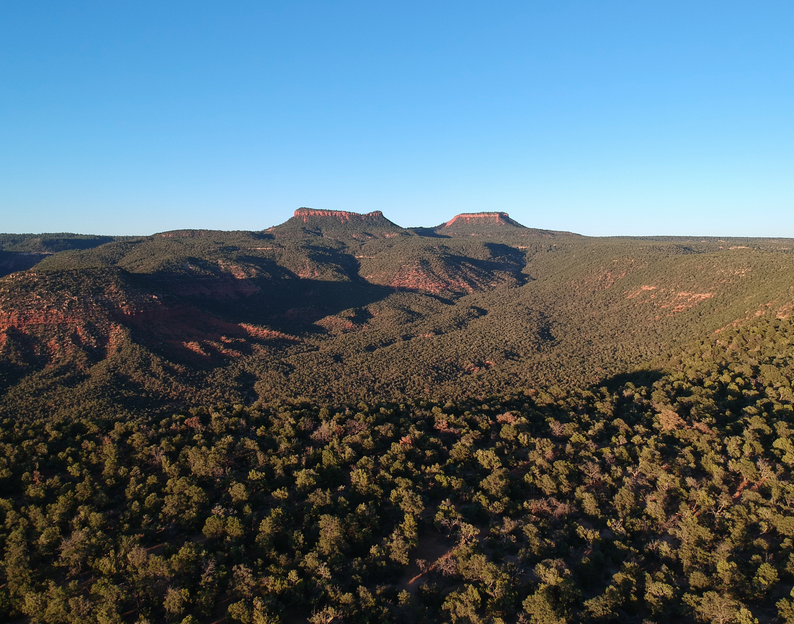
The Bears Ears buttes — called Náhonidzó in Navajo, meaning 'the escaping place' — earned that name during one of the darkest chapters in American history. In 1863–64, Colonel Kit Carson's scorched-earth campaign forced more than 8,500 Navajo men, women, and children on a 300-mile march to an internment camp in eastern New Mexico called Bosque Redondo (Hwéeldi, 'the place of suffering'). Several hundred Diné refused to surrender. They hid in the canyon labyrinths west and north of Bears Ears, using intimate knowledge of the terrain to evade Carson's troops — and some helped imprisoned relatives escape. When the Treaty of 1868 finally allowed the Navajo to return home, the bands who had sheltered at Náhonidzó walked back on their own terms, still free, never captured. Bears Ears is visible on clear days from the higher overlooks of the San Rafael Swell.
— Utah Diné Bikéyah; Fiveable
11.10 20th-Century Impacts
The twentieth century brought dramatic changes to Navajo life in Utah. More than 1,155,000 acres of the Navajo Nation lie in southeastern Utah, primarily in San Juan County — a landscape of red-rock mesas, deep canyons, and scattered communities connected by unpaved roads. Congress designated Utah as trustee for the Utah Navajo, initially establishing a three-person committee (later expanded to a twelve-member Navajo Commission) to manage leases, receive royalties from natural resource extraction, and improve living conditions (Utah Division of Indian Affairs).
For much of the century, education remained a painful issue. The federal boarding school system separated Navajo children from their families and communities, suppressing language and cultural practices in the name of assimilation. Two new high schools built during the 1970s and 1980s — one in Montezuma Creek and another in Monument Valley — helped reduce reliance on distant boarding schools. In 1984, the Navajo Nation took a landmark step by mandating Navajo-language instruction in its schools, affirming that the Diné language is an essential element of Navajo life, culture, and identity (PWNA; Indian Reservations).
Although the Navajo reservation lies well south of Emery County, the broader impacts of twentieth-century federal Indian policy — including dam construction, uranium mining, livestock reduction programs, and coal extraction — reverberated across the Colorado Plateau. Emery County’s own coal-mining economy existed within the same extractive framework that shaped Navajo resource politics, and the environmental consequences of mining touched Indigenous and settler communities alike.
11.11 Contemporary Cultural Exchange & Sovereignty
Today, the Navajo Nation is the largest federally recognized tribe in the United States, with a government, court system, and legislature exercising sovereignty over a reservation spanning parts of Arizona, New Mexico, and Utah. The Inter-Tribal Coalition that advocated for Bears Ears National Monument — comprising the Navajo Nation, Hopi Tribe, Ute Mountain Ute Tribe, Ute Indian Tribe of the Uintah and Ouray Reservation, and Zuni Pueblo — demonstrated that the ancient patterns of cross-cultural cooperation described in this chapter continue to evolve in new forms (Bears Ears Coalition).
Utah Diné Bikéyah, a nonprofit organization founded by Navajo elders and community members, works to protect the cultural and natural resources of southeastern Utah’s public lands. Their advocacy draws explicitly on the deep historical connections between the Diné people and the canyon country, including the Long Walk refuges, ancestral habitation sites, and sacred landscapes described in earlier sections (Utah Diné Bikéyah).
Cultural preservation efforts extend to museums, cultural centers, and language programs across the Navajo Nation. Art, music, and dance remain central to Navajo identity, while contemporary Navajo artists, writers, and filmmakers are finding new audiences for work that draws on centuries of tradition. The Navajo textile tradition — born from the Pueblo-Navajo cultural exchange described in Sections 11.2 and 11.3 — continues as both a living art form and a significant economic activity.
For Emery County, the relevance of these contemporary developments lies in shared stewardship of the Colorado Plateau. The same landscapes that Emery County residents hunt, hike, and ranch are sacred to Navajo, Ute, and Puebloan communities. As debates over public land management, energy development, and cultural resource protection continue to shape Utah politics, the deep history of Navajo and Puebloan interaction with this region provides essential context for informed decision-making.
11.12 Toponyms & Linguistic Imprints
Place names are among the most durable records of human presence in a landscape, and the Colorado Plateau bears the linguistic imprints of every culture that has inhabited it. The University of Utah’s “Native Places” project — a collaborative effort between the American West Center and tribal partners — has created an interactive GIS map that restores indigenous names to geographic features across the Intermountain West. The map is organized by five cultural groups: Ute, Shoshone, Goshute, Paiute, and Navajo (University of Utah, Native Places Atlas). Many official place names in northeastern Arizona, northwestern New Mexico, and southeastern Utah are of Navajo origin — either Anglicized versions of Diné words or English translations of Navajo descriptive names. Náhonidzó (Bears Ears, “the escaping place”) is perhaps the most significant for this chapter’s narrative. Other Navajo toponyms in southeastern Utah reflect the Diné relationship with specific landforms, water sources, and ecological zones that sustained their pastoral economy.
Within Emery County itself, documented Navajo place names are scarce — a reflection of the county’s position at the northern margin of sustained Navajo presence rather than evidence of absence. The dominant Indigenous toponymy in Emery County is Ute and, to a lesser extent, Paiute. Yet the absence of formal Navajo names does not mean the landscape was unknown to the Diné. Navajo oral traditions reference broader geographic features — the Green River, the Book Cliffs, the desert expanses north of the San Juan — in ways that suggest familiarity with the region even if permanent habitation was uncommon. [Needs additional sources: tribal consultation recommended for Navajo oral traditions related to the Emery County area.]
Puebloan linguistic influence in Emery County is even more indirect. The Pueblo languages (Tanoan, Keresan, Zunian) left their strongest toponymic imprint in New Mexico and northeastern Arizona. In Utah, Ancestral Puebloan presence is remembered primarily through archaeological site names assigned by European-American researchers (Anasazi, a Navajo word meaning roughly “ancient enemies” or “ancestors of our enemies,” has itself become a contested toponym that many Pueblo communities prefer to replace with “Ancestral Puebloan”). The ongoing effort to decolonize place names across the Colorado Plateau is both a linguistic project and an act of cultural restoration — one that acknowledges the deep, layered human history of landscapes that settler culture often treated as empty.
Sources
- History to Go (Utah State History) — “A History of Utah’s American Indians,” Chapters 5, 6, and 7. https://historytogo.utah.gov
- Utah Diné Bikéyah — “The Long Walk” and organizational history. https://utahdinebikeyah.org
- Indian Pueblo Cultural Center — “A Brief History of the Pueblo Revolt.” https://indianpueblo.org
- Natural History Museum of Utah — Range Creek Field Station research. https://nhmu.utah.edu
- USU Eastern Prehistoric Museum — “Eastern Utah Rock Art.” https://eastern.usu.edu/prehistoric-museum
- BLM — “Black Dragon Pictograph Panel.” https://www.blm.gov/visit/black-dragon-pictograph-panel
- National Park Service — “Ute Raiding Along the Old Spanish Trail.” https://www.nps.gov/articles/000/ute-raiding-along-the-old-spanish-trail.htm
- Bears Ears Inter-Tribal Coalition. https://www.bearsearscoalition.org
- The Livestock Conservancy — “Navajo Churro Sheep.” https://livestockconservancy.org/navajo-churro-sheep/
- University of Utah, American West Center — “Native Places Atlas.” https://awc.utah.edu/projects/nativeplaces.php
- Utah Division of Indian Affairs — “Navajo Nation.” https://indian.utah.gov/navajo-nation/
- Encyclopaedia Britannica — “Hogan” and “Pueblo Rebellion.” https://www.britannica.com
- climb-utah.com — “San Rafael Swell Pictographs & Petroglyphs.” https://www.climb-utah.com/SRS/srra.htm
- The Ethnic Home — “Navajo Churro Sheep and Wool.” https://www.theethnichome.com
- Utah History Encyclopedia (UEN) — “Native Americans.” https://www.uen.org/utah_history_encyclopedia/n/NATIVE_AMERICANS.shtml
Proposed Maps & Figures
- Map: Athabaskan migration routes into the American Southwest (showing alternative Utah corridor)
- Map: Pueblo Revolt refugee dispersal routes (1680–1700), with possible northward movements indicated
- Map: Pre-colonial trade networks on the Colorado Plateau, highlighting corridors through Emery County area
- Figure: Rock art style comparison — Barrier Canyon, Fremont, Ancestral Puebloan, and Navajo examples
- Photo: San Rafael Swell panel showing multi-period rock art layering
- Photo: Range Creek coursed-stone architecture (NHMU, with permission)
- Illustration: Male and female hogan construction diagrams
- Map: Long Walk route (1864) and Bears Ears refuge areas
- Photo: Bears Ears buttes (Náhonidzó)
- Map: Navajo Nation Utah reservation boundaries in San Juan County
- Screenshot/Map: University of Utah “Native Places” interactive atlas
Proposed Tables
- Timeline: Key events in Navajo–Puebloan–Ute interactions (1300–present)
- Comparison: Architectural traditions — Puebloan stone masonry, Navajo hogan, Fremont pit house, Ute wickiup